
Mount Ibuki
伊吹山
Maihara, Shiga · Elevation 1,377 m
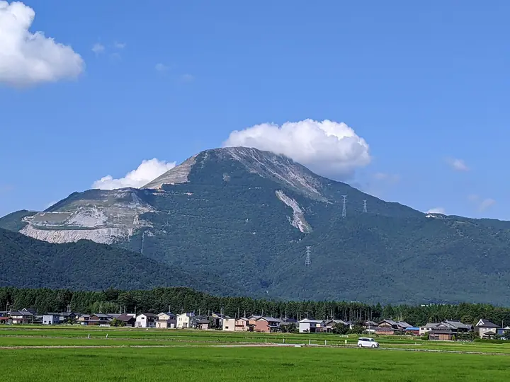
Mount Ibuki is a 1,377 m peak on the boundary between Maibara City in Shiga and Sekigahara Town and Ibigawa Town in Gifu, the highest summit in Shiga Prefecture and the centrepiece of Lake Biwa Quasi-National Park. Listed in Fukada Kyūya's Hyakumeizan, the Shin Hana-no-Hyakumeizan, and the Ittō-Sankakuten Hyakumeizan, the broad summit plateau of bamboo grass and limestone scree is famous for an exceptional flora, including dense stands of Filipendula multijuga and Polygonum bistortoides, and is designated a National Natural Monument. The mountain appears in the Kojiki and Nihon Shoki and is connected to the legend of Yamato Takeru. The Ibukiyama Driveway on the Gifu side reaches a parking area at the ninth station, while the Ueno trailhead on the Maibara side has remained closed since major slope failures during the heavy rains of July 2023.
Mount Ibuki at a glance
- Weather: The most settled day in the next 7 days is Wed, November 4: clear, gusts up to 6 m/s. Fri, Nov 6, Sat, Nov 7: strong wind (gusts up to 17 m/s).
- Route: The shortest is Mount Ibuki Return by the Central Trail from the Driveway Summit Car Park: about 54 min, 1.6 km, about 130 m of climbing.
Mount Ibuki weather (hourly, 14 days)
Sunrise today 06:17, sunset 16:59
| Tue, 11/3 | Wed, 11/4 | Thu, 11/5 | Fri, 11/6 | Sat, 11/7 | Sun, 11/8 | Mon, 11/9 | Tue, 11/10 | Wed, 11/11 | Thu, 11/12 | Fri, 11/13 | Sat, 11/14 | Sun, 11/15 | Mon, 11/16 | Tue, 11/17 | |||||||||||||||||||||||||||||||||||||||||||||||||||||||||||||||||||||||
|---|---|---|---|---|---|---|---|---|---|---|---|---|---|---|---|---|---|---|---|---|---|---|---|---|---|---|---|---|---|---|---|---|---|---|---|---|---|---|---|---|---|---|---|---|---|---|---|---|---|---|---|---|---|---|---|---|---|---|---|---|---|---|---|---|---|---|---|---|---|---|---|---|---|---|---|---|---|---|---|---|---|---|---|---|---|
| Japan time | 15 | 17 | 19 | 21 | 23 | 1 | 3 | 5 | 7 | 9 | 11 | 13 | 15 | 18 | 21 | 0 | 3 | 6 | 9 | 12 | 15 | 18 | 21 | 0 | 3 | 6 | 9 | 12 | 15 | 18 | 21 | 0 | 3 | 6 | 9 | 12 | 15 | 18 | 21 | 0 | 3 | 6 | 9 | 12 | 15 | 18 | 21 | 0 | 3 | 6 | 9 | 15 | 21 | 3 | 9 | 15 | 21 | 3 | 9 | 15 | 21 | 3 | 9 | 15 | 21 | 3 | 9 | 15 | 21 | 3 | 9 | 15 | 21 | 3 | 9 | 15 | 21 | 3 | 9 | 15 | 21 | 3 | 9 | 15 | |
 |  |   | | | | | |   | | | |   |   | |   | | |   |   | |   | | | |   |   |   | | | | | | | | | | | |   | | | | | | | | | | | | |   | | | | | | | | |  | | | | | | | | | | | | | | | | | | | | | | | ||
| Temperature | °C | 12° | 8° | 5° | 4° | 3° | 2° | 1° | 1° | 2° | 10° | 12° | 13° | 13° | 9° | 8° | 7° | 7° | 7° | 10° | 12° | 13° | 10° | 9° | 8° | 9° | 8° | 9° | 13° | 10° | 7° | 6° | 4° | 3° | 2° | 4° | 5° | 5° | 2° | 1° | 1° | 0° | 0° | 5° | 7° | 7° | 4° | 2° | 2° | 2° | 3° | 6° | 9° | 2° | 1° | 5° | 9° | 3° | 0° | 4° | 5° | 0° | -2° | 5° | 7° | 1° | 3° | 5° | 6° | 0° | -3° | 6° | 8° | 3° | 3° | 6° | 7° | 7° | 7° | 9° | 9° | 2° | 0° | 4° | 7° |
| Precipitation | mm | 3.7 | 6 | 4.1 | 1.4 | 0.1 | 3.8 | 0.1 | 0.2 | 1.1 | 0.2 | 0.2 | 0.1 | 0.3 | 0.2 | 0.4 | 0.3 | 0.3 | 1.5 | 1.4 | 0.2 | 0.3 | 0.2 | 1.1 | 8 | 12 | 0.8 | 0.3 | |||||||||||||||||||||||||||||||||||||||||||||||||||||||||
| New snow | cm | ||||||||||||||||||||||||||||||||||||||||||||||||||||||||||||||||||||||||||||||||||||
| Snow depth | cm | 0 | 0 | 0 | 0 | 0 | 0 | 0 | 0 | 0 | 0 | 0 | 0 | 0 | 0 | 0 | 0 | 0 | 0 | 0 | 0 | 0 | 0 | 0 | 0 | 0 | 0 | 0 | 0 | 0 | 0 | 0 | 0 | 0 | 0 | 0 | 0 | 0 | 0 | 0 | 0 | 0 | 0 | 0 | 0 | 0 | 0 | 0 | 0 | 0 | 0 | 0 | 0 | 0 | 0 | 0 | 0 | 0 | 0 | 0 | 0 | 0 | 0 | 0 | 0 | 0 | 0 | 0 | 0 | 0 | 0 | 0 | 0 | 0 | 0 | 0 | 0 | 0 | 0 | 0 | 0 | 0 | 0 | 0 | 0 |
| Wind | m/s | 3 | 3 | 3 | 2 | 2 | 2 | 2 | 2 | 2 | 0 | 1 | 2 | 1 | 0 | 1 | 1 | 1 | 1 | 1 | 0 | 0 | 0 | 1 | 1 | 2 | 3 | 3 | 6 | 6 | 6 | 4 | 5 | 4 | 4 | 4 | 5 | 5 | 3 | 2 | 2 | 2 | 1 | 3 | 4 | 4 | 2 | 1 | 1 | 2 | 2 | 2 | 4 | 2 | 1 | 1 | 4 | 4 | 5 | 6 | 5 | 2 | 2 | 2 | 3 | 2 | 3 | 4 | 5 | 3 | 1 | 1 | 3 | 1 | 1 | 1 | 1 | 1 | 1 | 2 | 6 | 2 | 4 | 1 | 2 |
| Wind gusts | m/s | 9 | 9 | 8 | 8 | 6 | 6 | 6 | 6 | 5 | 4 | 4 | 6 | 6 | 4 | 4 | 7 | 7 | 4 | 4 | 3 | 3 | 2 | 3 | 3 | 7 | 10 | 11 | 16 | 17 | 17 | 16 | 14 | 14 | 13 | 13 | 16 | 16 | 14 | 9 | 8 | 8 | 7 | 9 | 12 | 12 | 10 | 6 | 4 | 5 | 6 | 7 | 11 | 10 | 5 | 4 | 11 | 11 | 18 | 16 | 18 | 14 | 8 | 7 | 10 | 9 | 8 | 10 | 13 | 12 | 9 | 5 | 8 | 7 | 3 | 5 | 8 | 6 | 6 | 7 | 16 | 16 | 9 | 10 | 5 |
| Wind dir. | ↓ | ↓ | ↓ | ↓ | ↓ | ↓ | ↓ | ↓ | ↓ | ↓ | ↓ | ↓ | ↓ | ↓ | ↓ | ↓ | ↓ | ↓ | ↓ | ↓ | ↓ | ↓ | ↓ | ↓ | ↓ | ↓ | ↓ | ↓ | ↓ | ↓ | ↓ | ↓ | ↓ | ↓ | ↓ | ↓ | ↓ | ↓ | ↓ | ↓ | ↓ | ↓ | ↓ | ↓ | ↓ | ↓ | ↓ | ↓ | ↓ | ↓ | ↓ | ↓ | ↓ | ↓ | ↓ | ↓ | ↓ | ↓ | ↓ | ↓ | ↓ | ↓ | ↓ | ↓ | ↓ | ↓ | ↓ | ↓ | ↓ | ↓ | ↓ | ↓ | ↓ | ↓ | ↓ | ↓ | ↓ | ↓ | ↓ | ↓ | ↓ | ↓ | ↓ | ↓ | |
Mount Ibuki hiking routes
- Mount Ibuki Return by the Central Trail from the Driveway Summit Car Park 1.6 km · Ascent 127 m parking
- Mount Ibuki Summit Loop via West and Central Trails 2.1 km · Ascent 133 m parking
- Mount Ibuki Out-and-Back via the West Trail 2.5 km · Ascent 133 m parking
- Mount Ibuki Summit Circuit via the Western and Eastern Trails 2.9 km · Ascent 143 m parking
- Mount Ibuki Return from the Ueno Trailhead through the Numbered Stations 11.4 km · Ascent 1,156 m 伊吹登山口バス停 (Bus stop), 伊吹山ゴンドラ乗り場前駐車場 (parking)
Hiking times are estimates calculated from the terrain.
Huts, campsites and lodging near Mount Ibuki
Mountain huts
- えびす屋
- 雲上荘
- 宮崎屋
- 松仙館
- 対山館
Campsites
- Anegawa park
Lists that include Mount Ibuki
100 Famous Japanese Mountains · Japan 200 Famous Mountains · Japan's 300 Famous Mountains · New 100 Famous Flower Mountains · 100 Famous Mountains with First-order Triangulation Points · Highest Peaks by Prefecture · 100 Low Mountains of Japan · Illustrated Collection of Japan's Famous Mountains · Kansai 100 Famous Mountains · Tokai 100 Mountains · Kinki 100 Famous Mountains · 100 Mountains of Gifu · Omi 100 Mountains · Elevations of 1003 Mountains of Japan · 1000 Mountains of Japan
Mount Ibuki facts
- Also known as
- いぶきさん
- Elevation
- 1,377 m
- Location
- Maihara, Shiga
35.417773, 136.406261 - National Park
- 琵琶湖国定公園
- Website
- www.city.maibara.lg.jp
- Trail Map
- www.city.maibara.lg.jp
- Access Information
- www.city.maibara.lg.jp
- Wikipedia
- ja.wikipedia.org