
Mt. Ikedayama
池田山
Ibigawa, Gifu / Ikeda, Gifu · Elevation 924 m
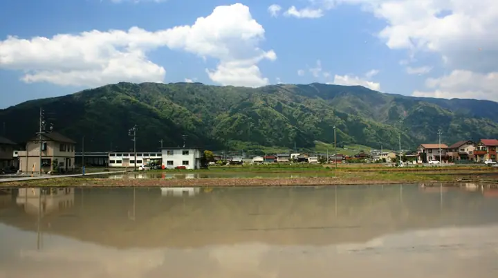
Mt. Ikedayama is a 923.9-meter peak in the Ibuki Mountains spanning Ikeda Town, Ibigawa Town (former Kasuga Village), and Tarui Town in Gifu Prefecture, featured in the Gifu Hyakuzan and Tōkai no Hyakuzan lists. Its mid-slopes form the 103-hectare Ikeda-no-Mori park maintained by Ikeda Town, with two graded trails — the Kasumigatani route and the Ōtsutani route — plus a ~3-kilometer foothill walkway connecting them. A paragliding and hang-gliding launch base with an observation deck near the eighth station offers panoramic views over the Nōbi Plain, also designated as one of Japan's 100 best night-view spots.
Mt. Ikedayama at a glance
- Weather: The most settled day in the next 7 days is Thu, November 5: clear, gusts up to 4 m/s. Fri, Nov 6: strong wind (gusts up to 15 m/s).
- Route: The shortest is Mount Ikeda Return from Kamagatani Gorge: about 5 h 57 min, 10.0 km, about 880 m of climbing.
Mt. Ikedayama weather (hourly, 14 days)
Sunrise today 06:17, sunset 16:58
| Tue, 11/3 | Wed, 11/4 | Thu, 11/5 | Fri, 11/6 | Sat, 11/7 | Sun, 11/8 | Mon, 11/9 | Tue, 11/10 | Wed, 11/11 | Thu, 11/12 | Fri, 11/13 | Sat, 11/14 | Sun, 11/15 | Mon, 11/16 | Tue, 11/17 | |||||||||||||||||||||||||||||||||||||||||||||||||||||||||||||||||||||||
|---|---|---|---|---|---|---|---|---|---|---|---|---|---|---|---|---|---|---|---|---|---|---|---|---|---|---|---|---|---|---|---|---|---|---|---|---|---|---|---|---|---|---|---|---|---|---|---|---|---|---|---|---|---|---|---|---|---|---|---|---|---|---|---|---|---|---|---|---|---|---|---|---|---|---|---|---|---|---|---|---|---|---|---|---|---|
| Japan time | 21 | 23 | 1 | 3 | 5 | 7 | 9 | 11 | 13 | 15 | 17 | 19 | 21 | 0 | 3 | 6 | 9 | 12 | 15 | 18 | 21 | 0 | 3 | 6 | 9 | 12 | 15 | 18 | 21 | 0 | 3 | 6 | 9 | 12 | 15 | 18 | 21 | 0 | 3 | 6 | 9 | 12 | 15 | 18 | 21 | 0 | 3 | 6 | 9 | 12 | 15 | 21 | 3 | 9 | 15 | 21 | 3 | 9 | 15 | 21 | 3 | 9 | 15 | 21 | 3 | 9 | 15 | 21 | 3 | 9 | 15 | 21 | 3 | 9 | 15 | 21 | 3 | 9 | 15 | 21 | 3 | 9 | 15 | 21 | |
 |   | | | |   | | |   | |   |   | |   | |   |   | | | | | | | | |   | |   | | | | | | | | | | | |  |  | | | | | | | | | | |   | | | | | | | | |  | | | | | | | | | | | | | |   | | | | | | | | | | ||
| Temperature | °C | 6° | 5° | 5° | 4° | 4° | 4° | 10° | 13° | 14° | 12° | 11° | 10° | 9° | 8° | 8° | 8° | 11° | 15° | 16° | 12° | 11° | 10° | 10° | 9° | 12° | 14° | 12° | 9° | 7° | 6° | 5° | 4° | 6° | 8° | 7° | 4° | 3° | 2° | 2° | 2° | 6° | 10° | 10° | 4° | 4° | 4° | 5° | 5° | 8° | 13° | 11° | 4° | 2° | 6° | 11° | 5° | 2° | 6° | 7° | 1° | 0° | 6° | 9° | 2° | 4° | 8° | 8° | 2° | -1° | 7° | 9° | 5° | 5° | 8° | 9° | 8° | 8° | 10° | 11° | 5° | 1° | 5° | 8° | 5° |
| Precipitation | mm | 4.2 | 1.3 | 1.3 | 0.2 | 0.1 | 7 | 8 | 0.3 | 0.2 | 0.1 | 0.2 | 0.3 | 0.2 | 0.1 | 0.2 | 0.9 | 1.0 | 1.0 | 6 | 11 | 0.5 | 0.1 | ||||||||||||||||||||||||||||||||||||||||||||||||||||||||||||||
| New snow | cm | ||||||||||||||||||||||||||||||||||||||||||||||||||||||||||||||||||||||||||||||||||||
| Snow depth | cm | 0 | 0 | 0 | 0 | 0 | 0 | 0 | 0 | 0 | 0 | 0 | 0 | 0 | 0 | 0 | 0 | 0 | 0 | 0 | 0 | 0 | 0 | 0 | 0 | 0 | 0 | 0 | 0 | 0 | 0 | 0 | 0 | 0 | 0 | 0 | 0 | 0 | 0 | 0 | 0 | 0 | 0 | 0 | 0 | 0 | 0 | 0 | 0 | 0 | 0 | 0 | 0 | 0 | 0 | 0 | 0 | 0 | 0 | 0 | 0 | 0 | 0 | 0 | 0 | 0 | 0 | 0 | 0 | 0 | 0 | 0 | 0 | 0 | 0 | 0 | 0 | 0 | 0 | 0 | 0 | 0 | 0 | 0 | 0 |
| Wind | m/s | 3 | 3 | 3 | 2 | 2 | 2 | 0 | 1 | 1 | 1 | 0 | 0 | 1 | 2 | 1 | 1 | 2 | 1 | 1 | 1 | 1 | 1 | 3 | 3 | 4 | 5 | 5 | 4 | 4 | 4 | 4 | 2 | 4 | 5 | 5 | 3 | 2 | 2 | 3 | 3 | 3 | 1 | 2 | 2 | 2 | 2 | 2 | 2 | 2 | 4 | 4 | 2 | 1 | 0 | 3 | 2 | 3 | 5 | 6 | 2 | 2 | 1 | 3 | 3 | 2 | 4 | 5 | 3 | 2 | 0 | 2 | 0 | 1 | 1 | 1 | 1 | 1 | 2 | 6 | 2 | 3 | 1 | 1 | 1 |
| Wind gusts | m/s | 7 | 6 | 7 | 6 | 6 | 5 | 5 | 4 | 5 | 5 | 3 | 2 | 2 | 6 | 5 | 3 | 4 | 4 | 4 | 3 | 3 | 7 | 8 | 9 | 10 | 13 | 15 | 13 | 11 | 12 | 12 | 10 | 11 | 14 | 14 | 12 | 8 | 7 | 8 | 8 | 9 | 8 | 6 | 6 | 5 | 4 | 5 | 5 | 5 | 10 | 11 | 8 | 6 | 4 | 8 | 9 | 14 | 13 | 17 | 14 | 7 | 6 | 9 | 8 | 7 | 10 | 13 | 12 | 7 | 5 | 7 | 6 | 2 | 3 | 5 | 3 | 5 | 6 | 15 | 15 | 8 | 8 | 5 | 4 |
| Wind dir. | ↓ | ↓ | ↓ | ↓ | ↓ | ↓ | ↓ | ↓ | ↓ | ↓ | ↓ | ↓ | ↓ | ↓ | ↓ | ↓ | ↓ | ↓ | ↓ | ↓ | ↓ | ↓ | ↓ | ↓ | ↓ | ↓ | ↓ | ↓ | ↓ | ↓ | ↓ | ↓ | ↓ | ↓ | ↓ | ↓ | ↓ | ↓ | ↓ | ↓ | ↓ | ↓ | ↓ | ↓ | ↓ | ↓ | ↓ | ↓ | ↓ | ↓ | ↓ | ↓ | ↓ | ↓ | ↓ | ↓ | ↓ | ↓ | ↓ | ↓ | ↓ | ↓ | ↓ | ↓ | ↓ | ↓ | ↓ | ↓ | ↓ | ↓ | ↓ | ↓ | ↓ | ↓ | ↓ | ↓ | ↓ | ↓ | ↓ | ↓ | ↓ | ↓ | ↓ | ↓ | |
Mt. Ikedayama hiking routes
Hiking times are estimates calculated from the terrain.
Huts, campsites and lodging near Mt. Ikedayama
Campsites
- 大津谷公園 キャンプ場
- 華音の森
Lists that include Mt. Ikedayama
Mt. Ikedayama facts
- Elevation
- 924 m
- Location
- Ibigawa, Gifu / Ikeda, Gifu
35.441075, 136.516939 - Website
- www.town.gifu-ikeda.lg.jp
- Access Information
- www.town.gifu-ikeda.lg.jp (PDF)
- Wikipedia
- ja.wikipedia.org