
Mt. Nanguusan
南宮山
Ōgaki-shi, Gifu / Tarui, Gifu · Elevation 419 m
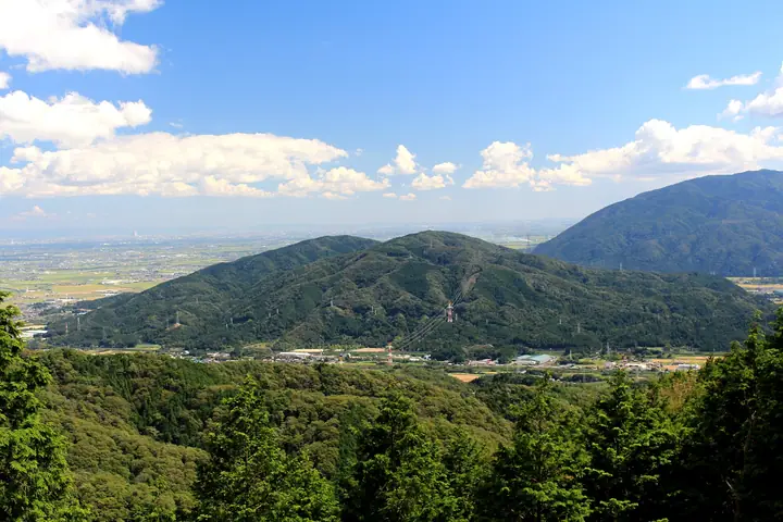
Mt. Nanguusan is a 419-meter peak at the southern end of the Ibuki Mountains, spanning Ōgaki City, Tarui Town, Sekigahara Town, and Yōrō Town in Gifu Prefecture, with the summit itself on the Ōgaki–Tarui boundary. The Mino ichinomiya shrine Nangū-Taisha sits at its southeastern foot, and during the 1600 Battle of Sekigahara the 404-meter sub-peak (now an observation deck) hosted the war camp of Mōri Hidemoto. Tarui Town maintains the ~3.8 km Nangūsan Hiking Course, looping from East Jadame Pond behind the shrine over the observation point and down to West Jadame Pond. The peak is featured in the Zoku Gifu Hyakuzan and Tōkai no Hyakuzan lists.
Mt. Nanguusan at a glance
- Weather: The most settled day in the next 7 days is Thu, November 5: cloudy, gusts up to 4 m/s. Fri, Nov 6: strong wind (gusts up to 15 m/s).
- Route: The shortest is Tarui, from Nangu Taisha to Mori Hidemoto's Camp Site on Mount Nangu and Back: about 2 h 39 min, 4.5 km, about 350 m of climbing.
Mt. Nanguusan weather (hourly, 14 days)
Sunrise today 06:17, sunset 16:59
| Tue, 11/3 | Wed, 11/4 | Thu, 11/5 | Fri, 11/6 | Sat, 11/7 | Sun, 11/8 | Mon, 11/9 | Tue, 11/10 | Wed, 11/11 | Thu, 11/12 | Fri, 11/13 | Sat, 11/14 | Sun, 11/15 | Mon, 11/16 | Tue, 11/17 | |||||||||||||||||||||||||||||||||||||||||||||||||||||||||||||||||||||||
|---|---|---|---|---|---|---|---|---|---|---|---|---|---|---|---|---|---|---|---|---|---|---|---|---|---|---|---|---|---|---|---|---|---|---|---|---|---|---|---|---|---|---|---|---|---|---|---|---|---|---|---|---|---|---|---|---|---|---|---|---|---|---|---|---|---|---|---|---|---|---|---|---|---|---|---|---|---|---|---|---|---|---|---|---|---|
| Japan time | 15 | 17 | 19 | 21 | 23 | 1 | 3 | 5 | 7 | 9 | 11 | 13 | 15 | 18 | 21 | 0 | 3 | 6 | 9 | 12 | 15 | 18 | 21 | 0 | 3 | 6 | 9 | 12 | 15 | 18 | 21 | 0 | 3 | 6 | 9 | 12 | 15 | 18 | 21 | 0 | 3 | 6 | 9 | 12 | 15 | 18 | 21 | 0 | 3 | 6 | 9 | 15 | 21 | 3 | 9 | 15 | 21 | 3 | 9 | 15 | 21 | 3 | 9 | 15 | 21 | 3 | 9 | 15 | 21 | 3 | 9 | 15 | 21 | 3 | 9 | 15 | 21 | 3 | 9 | 15 | 21 | 3 | 9 | 15 | |
 |  | |   | | | | |   | | | |   |   | |   | | |   | | | |   | | |   | |   | |  | | | |   | | | | | | | | | | | | | | | | | | |   | | | | | | | | |  | | | | | | | | | | | | | |   | | | | | | | | | ||
| Temperature | °C | 17° | 14° | 10° | 8° | 8° | 7° | 6° | 5° | 6° | 13° | 16° | 17° | 17° | 14° | 13° | 12° | 11° | 11° | 14° | 16° | 18° | 14° | 13° | 12° | 12° | 13° | 15° | 18° | 16° | 12° | 11° | 9° | 8° | 8° | 9° | 11° | 11° | 8° | 6° | 5° | 5° | 4° | 10° | 13° | 12° | 9° | 8° | 7° | 7° | 8° | 10° | 14° | 7° | 5° | 9° | 14° | 8° | 6° | 9° | 10° | 5° | 2° | 9° | 12° | 6° | 7° | 11° | 12° | 5° | 1° | 10° | 12° | 8° | 9° | 11° | 12° | 11° | 11° | 13° | 15° | 8° | 5° | 8° | 11° |
| Precipitation | mm | 2.6 | 3.6 | 1.3 | 0.8 | 0.1 | 4.5 | 0.4 | 0.1 | 0.5 | 0.1 | 0.2 | 0.1 | 0.3 | 0.6 | 0.6 | 0.1 | 0.4 | 4.6 | 8 | 0.2 | 0.2 | |||||||||||||||||||||||||||||||||||||||||||||||||||||||||||||||
| New snow | cm | ||||||||||||||||||||||||||||||||||||||||||||||||||||||||||||||||||||||||||||||||||||
| Snow depth | cm | 0 | 0 | 0 | 0 | 0 | 0 | 0 | 0 | 0 | 0 | 0 | 0 | 0 | 0 | 0 | 0 | 0 | 0 | 0 | 0 | 0 | 0 | 0 | 0 | 0 | 0 | 0 | 0 | 0 | 0 | 0 | 0 | 0 | 0 | 0 | 0 | 0 | 0 | 0 | 0 | 0 | 0 | 0 | 0 | 0 | 0 | 0 | 0 | 0 | 0 | 0 | 0 | 0 | 0 | 0 | 0 | 0 | 0 | 0 | 0 | 0 | 0 | 0 | 0 | 0 | 0 | 0 | 0 | 0 | 0 | 0 | 0 | 0 | 0 | 0 | 0 | 0 | 0 | 0 | 0 | 0 | 0 | 0 | 0 |
| Wind | m/s | 3 | 3 | 2 | 2 | 2 | 2 | 2 | 2 | 2 | 1 | 1 | 1 | 2 | 0 | 1 | 1 | 1 | 1 | 1 | 1 | 0 | 0 | 1 | 1 | 2 | 3 | 3 | 5 | 6 | 5 | 4 | 4 | 3 | 3 | 4 | 5 | 5 | 3 | 2 | 2 | 2 | 2 | 3 | 4 | 3 | 2 | 2 | 2 | 2 | 2 | 2 | 3 | 2 | 1 | 1 | 2 | 3 | 4 | 5 | 6 | 2 | 1 | 1 | 4 | 2 | 2 | 4 | 5 | 2 | 2 | 0 | 2 | 1 | 1 | 1 | 1 | 1 | 1 | 3 | 6 | 2 | 3 | 2 | 2 |
| Wind gusts | m/s | 8 | 7 | 7 | 6 | 5 | 5 | 5 | 5 | 5 | 5 | 4 | 5 | 5 | 4 | 3 | 7 | 7 | 2 | 4 | 3 | 3 | 2 | 2 | 2 | 7 | 6 | 9 | 12 | 15 | 14 | 12 | 11 | 11 | 9 | 11 | 14 | 13 | 12 | 8 | 5 | 5 | 5 | 8 | 11 | 11 | 8 | 6 | 5 | 5 | 6 | 6 | 10 | 8 | 6 | 4 | 7 | 10 | 13 | 12 | 16 | 13 | 6 | 5 | 9 | 9 | 6 | 9 | 12 | 12 | 5 | 4 | 7 | 6 | 2 | 3 | 5 | 4 | 4 | 7 | 14 | 14 | 8 | 7 | 7 |
| Wind dir. | ↓ | ↓ | ↓ | ↓ | ↓ | ↓ | ↓ | ↓ | ↓ | ↓ | ↓ | ↓ | ↓ | ↓ | ↓ | ↓ | ↓ | ↓ | ↓ | ↓ | ↓ | ↓ | ↓ | ↓ | ↓ | ↓ | ↓ | ↓ | ↓ | ↓ | ↓ | ↓ | ↓ | ↓ | ↓ | ↓ | ↓ | ↓ | ↓ | ↓ | ↓ | ↓ | ↓ | ↓ | ↓ | ↓ | ↓ | ↓ | ↓ | ↓ | ↓ | ↓ | ↓ | ↓ | ↓ | ↓ | ↓ | ↓ | ↓ | ↓ | ↓ | ↓ | ↓ | ↓ | ↓ | ↓ | ↓ | ↓ | ↓ | ↓ | ↓ | ↓ | ↓ | ↓ | ↓ | ↓ | ↓ | ↓ | ↓ | ↓ | ↓ | ↓ | ↓ | ↓ | |
Mt. Nanguusan hiking routes
Hiking times are estimates calculated from the terrain.
Huts, campsites and lodging near Mt. Nanguusan
Lodging
- 亀丸屋
- ますや旅館
Lists that include Mt. Nanguusan
Mt. Nanguusan facts
- Elevation
- 419 m
- Location
- Ōgaki-shi, Gifu / Tarui, Gifu
35.346828, 136.509783 - Website
- www.kankou-gifu.jp
- Trail Map
- www.town.tarui.lg.jp
- Wikipedia
- ja.wikipedia.org