
Mount Hotaka
武尊山
Kawaba, Gunma / Minakami, Gunma · Elevation 2,158 m
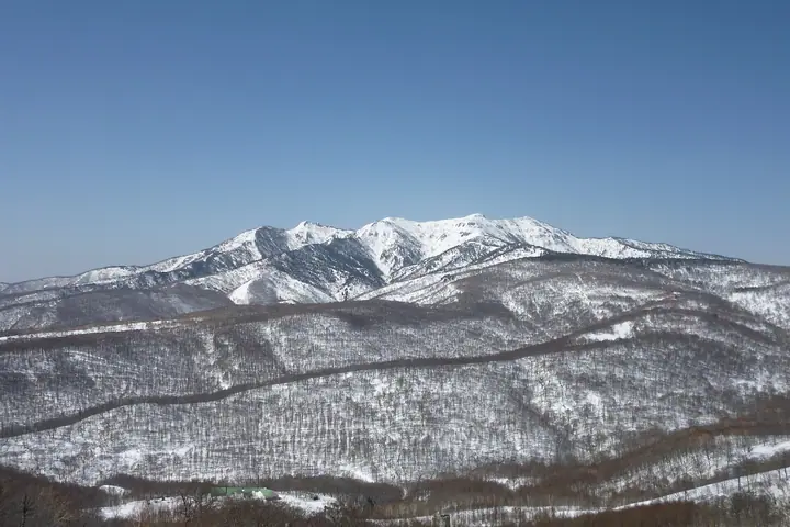
Mount Hotaka (Jōshū-Hotaka) is a 2,158 m Quaternary stratovolcano at the meeting point of Minakami, Kawaba, and Katashina in northern Gunma. It takes its name from the legendary prince Yamato Takeru, who is said to have campaigned through the area, and a statue of him stands on the Mae-Hotaka peak. Seven summits above 2,000 m surround the highest, Oki-Hotaka, and the area is the core of the Hotaka Nature Recreation Forest. Listed in the Hyakumeizan, Shin-Hana-no-Hyakumeizan, and the 100 First-Class Triangulation Mountains, the mountain holds separate annual openings in June at each of its three municipalities. Trails climb from the Hotaka Shrine in Minakami, the Kawaba campground, the Hotaka Pasture, and the Oguna-Hotaka ski resort, with chained passages and slippery serpentine ridges along the upper route.
Mount Hotaka at a glance
- Weather: The most settled day in the next 7 days is Wed, November 4: clear, gusts up to 9 m/s. Sat, Nov 7: strong wind (gusts up to 15 m/s).
- Route: The shortest is Mount Kengamine and Mount Okinuhotaka Return from Kawaba Ski Resort: about 3 h 32 min, 5.2 km, about 550 m of climbing.
Mount Hotaka weather (hourly, 14 days)
Sunrise today 06:08, sunset 16:46
| Tue, 11/3 | Wed, 11/4 | Thu, 11/5 | Fri, 11/6 | Sat, 11/7 | Sun, 11/8 | Mon, 11/9 | Tue, 11/10 | Wed, 11/11 | Thu, 11/12 | Fri, 11/13 | Sat, 11/14 | Sun, 11/15 | Mon, 11/16 | Tue, 11/17 | |||||||||||||||||||||||||||||||||||||||||||||||||||||||||||||||||||||||
|---|---|---|---|---|---|---|---|---|---|---|---|---|---|---|---|---|---|---|---|---|---|---|---|---|---|---|---|---|---|---|---|---|---|---|---|---|---|---|---|---|---|---|---|---|---|---|---|---|---|---|---|---|---|---|---|---|---|---|---|---|---|---|---|---|---|---|---|---|---|---|---|---|---|---|---|---|---|---|---|---|---|---|---|---|---|
| Japan time | 15 | 17 | 19 | 21 | 23 | 1 | 3 | 5 | 7 | 9 | 11 | 13 | 15 | 18 | 21 | 0 | 3 | 6 | 9 | 12 | 15 | 18 | 21 | 0 | 3 | 6 | 9 | 12 | 15 | 18 | 21 | 0 | 3 | 6 | 9 | 12 | 15 | 18 | 21 | 0 | 3 | 6 | 9 | 12 | 15 | 18 | 21 | 0 | 3 | 6 | 9 | 15 | 21 | 3 | 9 | 15 | 21 | 3 | 9 | 15 | 21 | 3 | 9 | 15 | 21 | 3 | 9 | 15 | 21 | 3 | 9 | 15 | 21 | 3 | 9 | 15 | 21 | 3 | 9 | 15 | 21 | 3 | 9 | 15 | |
  |   | |   |   | | | |  |   | | | | |   | | | |   |   | | | | | | | | | | | | |   |   |   | | | | | | | | | |   | | | | |   | | | | | | | | | | | | | | | | | | | | | | |  | | | | |   | | | | | | | ||
| Temperature | °C | 1° | -2° | -4° | -5° | -6° | -6° | -5° | -5° | -3° | 4° | 5° | 6° | 4° | 1° | 0° | 0° | 1° | 2° | 4° | 7° | 7° | 4° | 3° | 3° | 2° | 2° | 5° | 7° | 6° | 3° | 1° | -1° | -3° | -4° | -4° | -4° | -4° | -5° | -5° | -6° | -6° | -5° | -3° | -2° | -3° | -5° | -6° | -6° | -5° | -5° | 0° | -1° | -4° | -4° | -1° | 0° | -3° | -5° | -4° | -4° | -4° | -5° | -2° | -1° | -6° | -5° | -3° | -4° | -6° | -7° | 0° | 2° | -6° | -6° | 2° | 2° | 0° | 1° | 5° | 1° | -4° | -7° | -3° | 0° |
| Precipitation | mm | 0.2 | 0.4 | 9 | 8 | 1.1 | 0.9 | 0.3 | 0.4 | 0.2 | 0.2 | 0.5 | 0.8 | 0.7 | 1.1 | 2.1 | 2.1 | 2.2 | 1.4 | 0.9 | 0.8 | 0.2 | 0.1 | 0.1 | 0.4 | 0.2 | 0.2 | 2.4 | 4.7 | 7 | 2.1 | 0.3 | 5 | 1.4 | 0.3 | 4.2 | 4.8 | 2.4 | 7 | 0.7 | |||||||||||||||||||||||||||||||||||||||||||||
| New snow | cm | <.1 | 0.9 | 1.9 | 2.0 | 2.1 | 1.3 | 0.9 | 0.8 | 0.2 | <.1 | <.1 | <.1 | <.1 | <.1 | <.1 | 1.9 | 4.5 | 6.2 | 1.7 | 0.1 | 4.3 | 1.1 | 0.2 | 2.4 | 0.5 | |||||||||||||||||||||||||||||||||||||||||||||||||||||||||||
| Snow depth | cm | 0 | 0 | 0 | 0 | 0 | 0 | 0 | 0 | 0 | 0 | 0 | 0 | 0 | 0 | 0 | 0 | 0 | 0 | 0 | 0 | 0 | 0 | 0 | 0 | 0 | 0 | 0 | 0 | 0 | 0 | 0 | 0 | 0 | <1 | 2 | 3 | 4 | 5 | 5 | 6 | 6 | 6 | 6 | 6 | 5 | 5 | 5 | 5 | 5 | 5 | 5 | 3 | 3 | 3 | 3 | 1 | <1 | 2 | 5 | 8 | 8 | 8 | 8 | 7 | 7 | 6 | 9 | 9 | 9 | 9 | 8 | 7 | 7 | 7 | 7 | 5 | 4 | 3 | 3 | 1 | 2 | 2 | 2 | 2 |
| Wind | m/s | 2 | 2 | 2 | 2 | 2 | 2 | 2 | 2 | 2 | 0 | 2 | 3 | 3 | 2 | 2 | 2 | 1 | 0 | 1 | 1 | 1 | 1 | 0 | 1 | 1 | 2 | 3 | 3 | 3 | 3 | 3 | 3 | 3 | 3 | 2 | 4 | 3 | 3 | 2 | 2 | 3 | 2 | 2 | 3 | 3 | 2 | 2 | 1 | 1 | 1 | 1 | 2 | 2 | 2 | 1 | 3 | 2 | 3 | 4 | 7 | 3 | 2 | 1 | 2 | 1 | 1 | 3 | 5 | 3 | 3 | 1 | 1 | 0 | 1 | 1 | 1 | 1 | 1 | 1 | 5 | 4 | 3 | 2 | 1 |
| Wind gusts | m/s | 11 | 9 | 8 | 6 | 6 | 6 | 5 | 5 | 5 | 5 | 8 | 9 | 9 | 9 | 9 | 10 | 9 | 7 | 7 | 6 | 5 | 5 | 4 | 5 | 5 | 7 | 10 | 12 | 12 | 10 | 12 | 13 | 14 | 14 | 13 | 15 | 15 | 15 | 14 | 12 | 14 | 13 | 11 | 10 | 11 | 10 | 6 | 5 | 5 | 5 | 5 | 7 | 7 | 6 | 5 | 10 | 10 | 11 | 21 | 23 | 22 | 11 | 8 | 7 | 7 | 6 | 10 | 18 | 18 | 12 | 10 | 5 | 5 | 3 | 6 | 7 | 6 | 8 | 7 | 17 | 17 | 16 | 11 | 6 |
| Wind dir. | ↓ | ↓ | ↓ | ↓ | ↓ | ↓ | ↓ | ↓ | ↓ | ↓ | ↓ | ↓ | ↓ | ↓ | ↓ | ↓ | ↓ | ↓ | ↓ | ↓ | ↓ | ↓ | ↓ | ↓ | ↓ | ↓ | ↓ | ↓ | ↓ | ↓ | ↓ | ↓ | ↓ | ↓ | ↓ | ↓ | ↓ | ↓ | ↓ | ↓ | ↓ | ↓ | ↓ | ↓ | ↓ | ↓ | ↓ | ↓ | ↓ | ↓ | ↓ | ↓ | ↓ | ↓ | ↓ | ↓ | ↓ | ↓ | ↓ | ↓ | ↓ | ↓ | ↓ | ↓ | ↓ | ↓ | ↓ | ↓ | ↓ | ↓ | ↓ | ↓ | ↓ | ↓ | ↓ | ↓ | ↓ | ↓ | ↓ | ↓ | ↓ | ↓ | ↓ | ↓ | |
Mount Hotaka hiking routes
- Mount Kengamine and Mount Okinuhotaka Return from Kawaba Ski Resort 5.2 km · Ascent 553 m
- Mount Hotaka and Mount Kengamine Loop from Hotaka Shrine 13.1 km · Ascent 1,354 m 裏見ノ滝
- Joshu Hotakayama from Kawabadani Campground via Fudodake and Kawaba Kengamine to Oki-Hotaka 11.6 km · Ascent 1,288 m Kawabadani Campground (parking)
Hiking times are estimates calculated from the terrain.
Huts, campsites and lodging near Mount Hotaka
Mountain huts
Campsites
- Kawabadani Campground
Lists that include Mount Hotaka
100 Famous Japanese Mountains · Japan 200 Famous Mountains · Japan's 300 Famous Mountains · New 100 Famous Flower Mountains · 100 Famous Mountains with First-order Triangulation Points · 100 Famous Hot Spring Mountains · Kanto 100 Famous Mountains · Gunma 100 Famous Mountains · Elevations of 1003 Mountains of Japan · 1000 Mountains of Japan
Mount Hotaka facts
- Also known as
- 沖武尊 · 上州武尊山
- Elevation
- 2,158 m
- Location
- Kawaba, Gunma / Minakami, Gunma
36.805209, 139.132592 - Website
- www.rinya.maff.go.jp
- Trail Map
- www.pref.gunma.jp (PDF)
- Wikipedia
- ja.wikipedia.org