
Mount Ena
恵那山
Achi, Nagano · Elevation 2,191 m
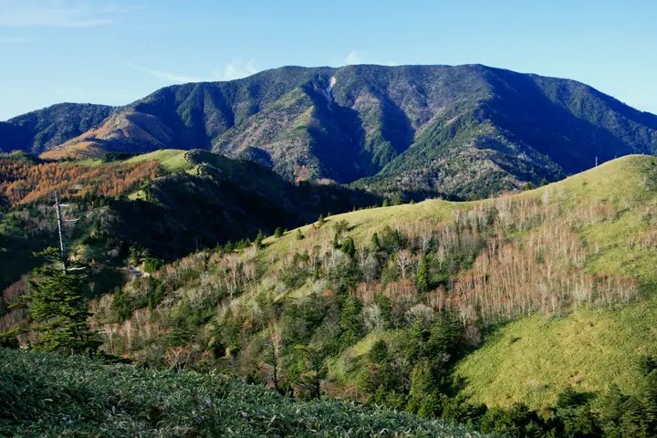
Mount Ena is a 2,191 m peak on the boundary between Achi Village in Nagano and Nakatsugawa in Gifu, an isolated massif marking the southern end of the Kiso Mountains (Central Alps) that separates the Ina and Kiso valleys. Listed in Fukada Kyūya's Hyakumeizan, the Shin Hana-no-Hyakumeizan, and the Ittō-Sankakuten Hyakumeizan, it is also a sacred mountain — its alternate kanji 胞山 reflects a tradition that the placenta of Izanami no Mikoto was buried here. The broad summit is forested and has limited views, but four trails are maintained: the Hirokawara route on the south, the Misaka-tōge route on the north, the Kuroizawa route, and the Maemiya route, accommodating climbers of all levels. The Hirokawara route, including its forest-road approach, is overseen by the Achi Tourism Bureau, while the other trails are managed by the Nakatsugawa Tourism Association.
Mount Ena at a glance
- Weather: The most settled day in the next 7 days is Sun, November 8: clear, gusts up to 7 m/s. Fri, Nov 6, Sat, Nov 7: strong wind (gusts up to 17 m/s).
- Route: The shortest is Mount Ena via the Hirogawara Route: about 6 h 33 min, 11.4 km, about 1,090 m of climbing.
Mount Ena weather (hourly, 14 days)
Sunrise today 06:12, sunset 16:54
| Tue, 11/3 | Wed, 11/4 | Thu, 11/5 | Fri, 11/6 | Sat, 11/7 | Sun, 11/8 | Mon, 11/9 | Tue, 11/10 | Wed, 11/11 | Thu, 11/12 | Fri, 11/13 | Sat, 11/14 | Sun, 11/15 | Mon, 11/16 | Tue, 11/17 | |||||||||||||||||||||||||||||||||||||||||||||||||||||||||||||||||||||||
|---|---|---|---|---|---|---|---|---|---|---|---|---|---|---|---|---|---|---|---|---|---|---|---|---|---|---|---|---|---|---|---|---|---|---|---|---|---|---|---|---|---|---|---|---|---|---|---|---|---|---|---|---|---|---|---|---|---|---|---|---|---|---|---|---|---|---|---|---|---|---|---|---|---|---|---|---|---|---|---|---|---|---|---|---|---|
| Japan time | 15 | 17 | 19 | 21 | 23 | 1 | 3 | 5 | 7 | 9 | 11 | 13 | 15 | 18 | 21 | 0 | 3 | 6 | 9 | 12 | 15 | 18 | 21 | 0 | 3 | 6 | 9 | 12 | 15 | 18 | 21 | 0 | 3 | 6 | 9 | 12 | 15 | 18 | 21 | 0 | 3 | 6 | 9 | 12 | 15 | 18 | 21 | 0 | 3 | 6 | 9 | 15 | 21 | 3 | 9 | 15 | 21 | 3 | 9 | 15 | 21 | 3 | 9 | 15 | 21 | 3 | 9 | 15 | 21 | 3 | 9 | 15 | 21 | 3 | 9 | 15 | 21 | 3 | 9 | 15 | 21 | 3 | 9 | 15 | |
 |   |  | | | | | |   | | |   |   |   | | | | |   |   |   |   | |   | | | | | |  | | | | | | | | | | | | | | | | | | | | | | |   | | | | |   | | | |  | | | | | | | | | | | | | | | | | | | | | | | ||
| Temperature | °C | 7° | 2° | 1° | 0° | 0° | -1° | 0° | 0° | 1° | 7° | 9° | 9° | 7° | 4° | 3° | 3° | 4° | 4° | 6° | 9° | 8° | 5° | 5° | 4° | 4° | 4° | 5° | 8° | 7° | 2° | -1° | -2° | -4° | -4° | 0° | 3° | 1° | -4° | -6° | -7° | -7° | -6° | 1° | 4° | 3° | -1° | -1° | -1° | -1° | 0° | 3° | 4° | -2° | -5° | 2° | 3° | -2° | -6° | -3° | 0° | -6° | -6° | 1° | 2° | -4° | -4° | 0° | 3° | -6° | -3° | 2° | 3° | -2° | -1° | 5° | 5° | 3° | 4° | 5° | 7° | -3° | -3° | 2° | 2° |
| Precipitation | mm | 0.2 | 0.2 | 0.9 | 6 | 8 | 0.3 | 0.6 | 0.9 | 0.6 | 3.0 | 1.0 | 1.6 | 0.6 | 24 | 13 | 0.4 | 1.0 | 1.6 | ||||||||||||||||||||||||||||||||||||||||||||||||||||||||||||||||||
| New snow | cm | ||||||||||||||||||||||||||||||||||||||||||||||||||||||||||||||||||||||||||||||||||||
| Snow depth | cm | 0 | 0 | 0 | 0 | 0 | 0 | 0 | 0 | 0 | 0 | 0 | 0 | 0 | 0 | 0 | 0 | 0 | 0 | 0 | 0 | 0 | 0 | 0 | 0 | 0 | 0 | 0 | 0 | 0 | 0 | 0 | 0 | 0 | 0 | 0 | 0 | 0 | 0 | 0 | 0 | 0 | 0 | 0 | 0 | 0 | 0 | 0 | 0 | 0 | 0 | 0 | 0 | 0 | 0 | 0 | 0 | 0 | 0 | 0 | 0 | 0 | 0 | 0 | 0 | 0 | 0 | 0 | 0 | 0 | 0 | 0 | 0 | 0 | 0 | 0 | 0 | 0 | 0 | 0 | 0 | 0 | 0 | 0 | 0 |
| Wind | m/s | 2 | 1 | 1 | 1 | 1 | 1 | 1 | 1 | 2 | 1 | 1 | 2 | 1 | 1 | 2 | 1 | 2 | 2 | 1 | 1 | 0 | 0 | 0 | 1 | 0 | 1 | 2 | 4 | 5 | 3 | 2 | 2 | 2 | 2 | 3 | 6 | 4 | 2 | 0 | 0 | 0 | 0 | 0 | 2 | 1 | 0 | 1 | 1 | 1 | 1 | 1 | 3 | 0 | 1 | 1 | 3 | 1 | 4 | 2 | 3 | 1 | 2 | 1 | 2 | 0 | 0 | 1 | 3 | 2 | 1 | 1 | 2 | 1 | 2 | 1 | 1 | 1 | 1 | 1 | 5 | 1 | 1 | 0 | 1 |
| Wind gusts | m/s | 7 | 6 | 4 | 4 | 3 | 3 | 3 | 4 | 4 | 4 | 5 | 8 | 7 | 4 | 6 | 10 | 10 | 6 | 5 | 5 | 4 | 3 | 3 | 3 | 5 | 7 | 8 | 13 | 15 | 14 | 10 | 10 | 9 | 9 | 10 | 17 | 17 | 13 | 7 | 5 | 4 | 4 | 4 | 7 | 6 | 4 | 3 | 4 | 3 | 3 | 4 | 11 | 8 | 4 | 5 | 10 | 9 | 16 | 13 | 12 | 10 | 5 | 6 | 9 | 5 | 5 | 6 | 9 | 7 | 5 | 4 | 7 | 6 | 5 | 6 | 7 | 9 | 9 | 6 | 16 | 15 | 4 | 4 | 7 |
| Wind dir. | ↓ | ↓ | ↓ | ↓ | ↓ | ↓ | ↓ | ↓ | ↓ | ↓ | ↓ | ↓ | ↓ | ↓ | ↓ | ↓ | ↓ | ↓ | ↓ | ↓ | ↓ | ↓ | ↓ | ↓ | ↓ | ↓ | ↓ | ↓ | ↓ | ↓ | ↓ | ↓ | ↓ | ↓ | ↓ | ↓ | ↓ | ↓ | ↓ | ↓ | ↓ | ↓ | ↓ | ↓ | ↓ | ↓ | ↓ | ↓ | ↓ | ↓ | ↓ | ↓ | ↓ | ↓ | ↓ | ↓ | ↓ | ↓ | ↓ | ↓ | ↓ | ↓ | ↓ | ↓ | ↓ | ↓ | ↓ | ↓ | ↓ | ↓ | ↓ | ↓ | ↓ | ↓ | ↓ | ↓ | ↓ | ↓ | ↓ | ↓ | ↓ | ↓ | ↓ | ||
Mount Ena hiking routes
- Mount Ena via the Hirogawara Route 11.4 km · Ascent 1,094 m Hirogawara Trailhead Parking Area
- Mount Ena Return from Misaka Pass 13.3 km · Ascent 1,233 m parking
Hiking times are estimates calculated from the terrain.
Huts, campsites and lodging near Mount Ena
Mountain huts
Lists that include Mount Ena
100 Famous Japanese Mountains · Japan 200 Famous Mountains · Japan's 300 Famous Mountains · New 100 Famous Flower Mountains · 100 Famous Mountains with First-order Triangulation Points · Illustrated Collection of Japan's Famous Mountains · Tokai 100 Mountains · Shinshu 100 Famous Mountains · 100 Mountains of Gifu · Achi 7 Summits · Elevations of 1003 Mountains of Japan · 1000 Mountains of Japan
Mount Ena facts
- Also known as
- 胞山 · 舟覆山
- Elevation
- 2,191 m
- Location
- Achi, Nagano
35.443142, 137.597832 - Website
- www.city.nakatsugawa.lg.jp
- Trail Map
- www.city.nakatsugawa.lg.jp (PDF)
- Wikipedia
- ja.wikipedia.org