
Mount Amari
甘利山
Minami-Alps, Yamanashi / Nirasaki, Yamanashi · Elevation 1,731 m
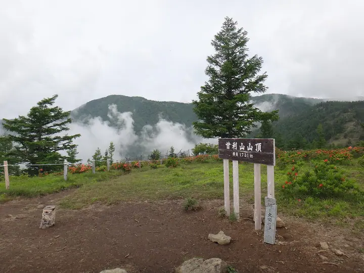
Mount Amari is a 1,731 m peak in western Nirasaki City, Yamanashi, rising as a forward outpost of the Southern Alps. The summit offers sweeping views of Mount Fuji, the Yatsugatake range, the Kōfu Basin, and the Hōō Sanzan, and in mid-June some 150,000 renge azaleas bathe the summit meadow in vivid red-orange. The walk from Hirogawara parking to the top takes only about 30 minutes, making it popular with families. It appears in Yamanashi Hyakumeizan, Kōshin-etsu Hyakumeizan, and the Yamanashi Hiking 100 selections.
Mount Amari at a glance
- Weather: The most settled day in the next 7 days is Sun, November 8: clear, gusts up to 8 m/s.
- Route: The shortest is Mount Amari to Mount Sentoboshi Return via Okuamari and Onishi Peak: about 4 h 33 min, 7.3 km, about 630 m of climbing.
Mount Amari weather (hourly, 14 days)
Sunrise today 06:10, sunset 16:51
| Tue, 11/3 | Wed, 11/4 | Thu, 11/5 | Fri, 11/6 | Sat, 11/7 | Sun, 11/8 | Mon, 11/9 | Tue, 11/10 | Wed, 11/11 | Thu, 11/12 | Fri, 11/13 | Sat, 11/14 | Sun, 11/15 | Mon, 11/16 | Tue, 11/17 | |||||||||||||||||||||||||||||||||||||||||||||||||||||||||||||||||||||||
|---|---|---|---|---|---|---|---|---|---|---|---|---|---|---|---|---|---|---|---|---|---|---|---|---|---|---|---|---|---|---|---|---|---|---|---|---|---|---|---|---|---|---|---|---|---|---|---|---|---|---|---|---|---|---|---|---|---|---|---|---|---|---|---|---|---|---|---|---|---|---|---|---|---|---|---|---|---|---|---|---|---|---|---|---|---|
| Japan time | 15 | 17 | 19 | 21 | 23 | 1 | 3 | 5 | 7 | 9 | 11 | 13 | 15 | 18 | 21 | 0 | 3 | 6 | 9 | 12 | 15 | 18 | 21 | 0 | 3 | 6 | 9 | 12 | 15 | 18 | 21 | 0 | 3 | 6 | 9 | 12 | 15 | 18 | 21 | 0 | 3 | 6 | 9 | 12 | 15 | 18 | 21 | 0 | 3 | 6 | 9 | 15 | 21 | 3 | 9 | 15 | 21 | 3 | 9 | 15 | 21 | 3 | 9 | 15 | 21 | 3 | 9 | 15 | 21 | 3 | 9 | 15 | 21 | 3 | 9 | 15 | 21 | 3 | 9 | 15 | 21 | 3 | 9 | 15 | |
  |   |   | | | | | | |   |   |   |   | | | | | | | | |   | |  |   | | |   | | | | | |   | |  | | | | | | | | | | | | | | | | |   | | | | | | | |   |  | | | | | | | | | | | | | | | | | | | | | | | ||
| Temperature | °C | 9° | 5° | 3° | 1° | 0° | 0° | 2° | 2° | 3° | 7° | 10° | 10° | 8° | 6° | 6° | 6° | 6° | 7° | 10° | 14° | 10° | 8° | 7° | 6° | 6° | 6° | 11° | 15° | 14° | 6° | 3° | 1° | -1° | -3° | 5° | 9° | 8° | 1° | 0° | -1° | 0° | 0° | 7° | 10° | 8° | 3° | 3° | 3° | 3° | 3° | 6° | 7° | 2° | -1° | 5° | 6° | 2° | 0° | 3° | 6° | -1° | -1° | 4° | 6° | 1° | 0° | 5° | 8° | 1° | 0° | 5° | 8° | 0° | 0° | 7° | 9° | 6° | 6° | 10° | 13° | 4° | 3° | 5° | 6° |
| Precipitation | mm | 1.5 | 2.1 | 2.5 | 1.6 | 1.4 | 0.8 | 0.7 | 0.4 | 0.2 | 0.3 | 0.7 | 0.2 | 7 | 13 | 6 | 0.2 | 2.1 | 0.2 | 0.3 | 0.4 | 0.3 | 0.2 | 0.5 | 0.7 | 0.3 | 0.3 | 0.7 | 1.1 | 3.1 | 5 | 4.7 | 3.8 | 0.5 | 0.9 | 1.5 | 0.3 | 2.5 | 1.4 | 0.2 | 11 | 19 | 0.2 | 0.5 | 0.4 | 0.3 | |||||||||||||||||||||||||||||||||||||||
| New snow | cm | <.1 | <.1 | <.1 | |||||||||||||||||||||||||||||||||||||||||||||||||||||||||||||||||||||||||||||||||
| Snow depth | cm | 0 | 0 | 0 | 0 | 0 | 0 | 0 | 0 | 0 | 0 | 0 | 0 | 0 | 0 | 0 | 0 | 0 | 0 | 0 | 0 | 0 | 0 | 0 | 0 | 0 | 0 | 0 | 0 | 0 | 0 | 0 | 0 | 0 | 0 | 0 | 0 | 0 | 0 | 0 | 0 | 0 | 0 | 0 | 0 | 0 | 0 | 0 | 0 | 0 | 0 | 0 | 0 | 0 | 0 | 0 | 0 | 0 | 0 | 0 | 0 | 0 | 0 | 0 | 0 | 0 | 0 | 0 | 0 | 0 | 0 | 0 | 0 | 0 | 0 | 0 | 0 | 0 | 0 | 0 | 0 | 0 | 0 | 0 | 0 |
| Wind | m/s | 1 | 0 | 1 | 1 | 1 | 1 | 1 | 0 | 0 | 1 | 2 | 2 | 1 | 1 | 1 | 1 | 1 | 0 | 0 | 1 | 0 | 0 | 0 | 1 | 1 | 1 | 1 | 1 | 1 | 1 | 2 | 2 | 2 | 3 | 1 | 0 | 1 | 1 | 1 | 1 | 1 | 1 | 1 | 1 | 1 | 0 | 1 | 1 | 1 | 1 | 0 | 1 | 1 | 1 | 1 | 1 | 1 | 2 | 2 | 1 | 0 | 1 | 1 | 1 | 0 | 1 | 1 | 1 | 0 | 0 | 1 | 1 | 0 | 1 | 0 | 1 | 0 | 1 | 0 | 1 | 0 | 0 | 1 | 1 |
| Wind gusts | m/s | 7 | 7 | 6 | 6 | 7 | 6 | 6 | 5 | 5 | 6 | 7 | 7 | 7 | 7 | 7 | 7 | 8 | 9 | 6 | 7 | 9 | 8 | 6 | 7 | 9 | 9 | 8 | 8 | 8 | 8 | 10 | 12 | 13 | 13 | 13 | 13 | 11 | 9 | 8 | 8 | 8 | 7 | 7 | 8 | 7 | 7 | 7 | 7 | 8 | 8 | 8 | 9 | 7 | 6 | 7 | 10 | 8 | 12 | 15 | 15 | 7 | 5 | 7 | 8 | 7 | 5 | 8 | 11 | 6 | 5 | 5 | 6 | 6 | 6 | 7 | 9 | 10 | 10 | 9 | 9 | 9 | 6 | 6 | 7 |
| Wind dir. | ↓ | ↓ | ↓ | ↓ | ↓ | ↓ | ↓ | ↓ | ↓ | ↓ | ↓ | ↓ | ↓ | ↓ | ↓ | ↓ | ↓ | ↓ | ↓ | ↓ | ↓ | ↓ | ↓ | ↓ | ↓ | ↓ | ↓ | ↓ | ↓ | ↓ | ↓ | ↓ | ↓ | ↓ | ↓ | ↓ | ↓ | ↓ | ↓ | ↓ | ↓ | ↓ | ↓ | ↓ | ↓ | ↓ | ↓ | ↓ | ↓ | ↓ | ↓ | ↓ | ↓ | ↓ | ↓ | ↓ | ↓ | ↓ | ↓ | ↓ | ↓ | ↓ | ↓ | ↓ | ↓ | ↓ | ↓ | ↓ | ↓ | ↓ | ↓ | ↓ | ↓ | ↓ | ↓ | ↓ | ↓ | ↓ | ↓ | ↓ | ↓ | ↓ | ↓ | ↓ | |
Mount Amari hiking routes
Hiking times are estimates calculated from the terrain.
Huts, campsites and lodging near Mount Amari
Campsites
- 青木鉱泉キャンプ場
Lodging
- Mt. Amari Green Lodge
- Aoki Kosen
Lists that include Mount Amari
Koshinetsu 100 Famous Mountains · Yamanashi 100 Famous Mountains · 1000 Mountains of Japan
Mount Amari facts
- Elevation
- 1,731 m
- Location
- Minami-Alps, Yamanashi / Nirasaki, Yamanashi
35.681143, 138.376585 - Website
- www.nirasaki-kankou.jp
- Trail Map
- www.nirasaki-kankou.jp (PDF)
- Wikipedia
- ja.wikipedia.org