
Mount Kushigata
櫛形山
Fujikawa, Yamanashi / Minami-Alps, Yamanashi · Elevation 2,053 m
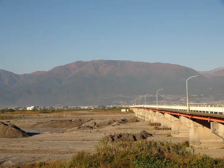
Mount Kushigata is a 2,053 m peak straddling Minami-Alps City and Fujikawa Town in Yamanashi, forming a prominent vanguard of the South Alps along the western rim of the Kōfu Basin. Its name derives from the gentle ridge that resembles an inverted Japanese hair-comb, and it is counted among Japan's 200 Famous Mountains and the Yamanashi 100. Just north of the summit lies Ayame-daira, a sub-alpine meadow renowned for its native irises and a colourful seasonal display of Tamura-sō, fireweed and other wildflowers.
Mount Kushigata at a glance
- Weather: The most settled day in the next 7 days is Sun, November 8: clear, gusts up to 7 m/s.
- Route: The shortest is Mount Kushigata, Mount Hadaka and Ayamedaira Circuit: about 5 h 16 min, 9.2 km, about 570 m of climbing.
Mount Kushigata weather (hourly, 14 days)
Sunrise today 06:10, sunset 16:51
| Tue, 11/3 | Wed, 11/4 | Thu, 11/5 | Fri, 11/6 | Sat, 11/7 | Sun, 11/8 | Mon, 11/9 | Tue, 11/10 | Wed, 11/11 | Thu, 11/12 | Fri, 11/13 | Sat, 11/14 | Sun, 11/15 | Mon, 11/16 | Tue, 11/17 | |||||||||||||||||||||||||||||||||||||||||||||||||||||||||||||||||||||||
|---|---|---|---|---|---|---|---|---|---|---|---|---|---|---|---|---|---|---|---|---|---|---|---|---|---|---|---|---|---|---|---|---|---|---|---|---|---|---|---|---|---|---|---|---|---|---|---|---|---|---|---|---|---|---|---|---|---|---|---|---|---|---|---|---|---|---|---|---|---|---|---|---|---|---|---|---|---|---|---|---|---|---|---|---|---|
| Japan time | 15 | 17 | 19 | 21 | 23 | 1 | 3 | 5 | 7 | 9 | 11 | 13 | 15 | 18 | 21 | 0 | 3 | 6 | 9 | 12 | 15 | 18 | 21 | 0 | 3 | 6 | 9 | 12 | 15 | 18 | 21 | 0 | 3 | 6 | 9 | 12 | 15 | 18 | 21 | 0 | 3 | 6 | 9 | 12 | 15 | 18 | 21 | 0 | 3 | 6 | 9 | 15 | 21 | 3 | 9 | 15 | 21 | 3 | 9 | 15 | 21 | 3 | 9 | 15 | 21 | 3 | 9 | 15 | 21 | 3 | 9 | 15 | 21 | 3 | 9 | 15 | 21 | 3 | 9 | 15 | 21 | 3 | 9 | 15 | |
  |   | | | |   | |   |   |   | |   |   | | | | | | | | |   | |   |   | | |  | |  | | | | | | | | | | | | | | | | | | | | | | | | | |   | |   | | |   |  | | | | | | | | | | | | | | | | | | | | | | | ||
| Temperature | °C | 7° | 3° | 2° | 0° | -2° | -2° | -1° | 0° | 1° | 5° | 7° | 6° | 5° | 3° | 3° | 3° | 4° | 4° | 7° | 11° | 8° | 6° | 5° | 4° | 4° | 4° | 8° | 13° | 12° | 5° | 1° | -2° | -3° | -5° | 4° | 7° | 6° | 0° | -1° | -1° | -2° | -1° | 4° | 7° | 6° | 1° | 2° | 1° | 1° | 1° | 4° | 5° | 0° | -3° | 3° | 5° | 0° | -2° | 0° | 3° | -3° | -4° | 2° | 4° | -2° | -2° | 3° | 5° | -1° | -2° | 2° | 5° | -2° | -2° | 5° | 6° | 4° | 4° | 8° | 11° | 2° | 1° | 2° | 4° |
| Precipitation | mm | 0.3 | 0.5 | 1.1 | 2.1 | 0.6 | 0.3 | 0.7 | 0.1 | 8 | 14 | 6 | 0.7 | 1.5 | 1.1 | 1.8 | 0.9 | 0.6 | 0.3 | 0.9 | 0.2 | 0.2 | 0.7 | 8 | 0.5 | 0.4 | 0.1 | 0.3 | 0.2 | 0.2 | 2.0 | 1.7 | 0.2 | 0.7 | 1.0 | 0.2 | 0.2 | 0.2 | 12 | 20 | 0.5 | 0.2 | 0.2 | 0.3 | 1.3 | 1.3 | |||||||||||||||||||||||||||||||||||||||
| New snow | cm | <.1 | <.1 | ||||||||||||||||||||||||||||||||||||||||||||||||||||||||||||||||||||||||||||||||||
| Snow depth | cm | 0 | 0 | 0 | 0 | 0 | 0 | 0 | 0 | 0 | 0 | 0 | 0 | 0 | 0 | 0 | 0 | 0 | 0 | 0 | 0 | 0 | 0 | 0 | 0 | 0 | 0 | 0 | 0 | 0 | 0 | 0 | 0 | 0 | 0 | 0 | 0 | 0 | 0 | 0 | 0 | 0 | 0 | 0 | 0 | 0 | 0 | 0 | 0 | 0 | 0 | 0 | 0 | 0 | 0 | 0 | 0 | 0 | 0 | 0 | 0 | 0 | 0 | 0 | 0 | 0 | 0 | 0 | 0 | 0 | 0 | 0 | 0 | 0 | 0 | 0 | 0 | 0 | 0 | 0 | 0 | 0 | 0 | 0 | 0 |
| Wind | m/s | 1 | 0 | 1 | 1 | 1 | 1 | 1 | 0 | 0 | 0 | 1 | 1 | 0 | 0 | 1 | 1 | 0 | 1 | 0 | 1 | 0 | 0 | 0 | 1 | 1 | 1 | 0 | 0 | 0 | 1 | 1 | 1 | 1 | 2 | 0 | 1 | 1 | 0 | 0 | 1 | 1 | 0 | 1 | 1 | 1 | 0 | 1 | 0 | 1 | 1 | 0 | 1 | 1 | 1 | 0 | 2 | 1 | 1 | 1 | 2 | 0 | 1 | 1 | 1 | 0 | 1 | 0 | 1 | 0 | 0 | 0 | 1 | 0 | 1 | 0 | 1 | 1 | 1 | 1 | 1 | 0 | 0 | 1 | 1 |
| Wind gusts | m/s | 7 | 7 | 5 | 5 | 5 | 5 | 4 | 4 | 4 | 5 | 6 | 6 | 5 | 4 | 4 | 5 | 5 | 5 | 5 | 6 | 7 | 6 | 4 | 5 | 6 | 6 | 6 | 8 | 7 | 6 | 6 | 7 | 8 | 8 | 11 | 11 | 10 | 8 | 6 | 6 | 5 | 5 | 5 | 7 | 7 | 7 | 6 | 5 | 6 | 5 | 6 | 9 | 7 | 5 | 6 | 10 | 9 | 9 | 12 | 12 | 8 | 4 | 5 | 8 | 7 | 4 | 6 | 9 | 5 | 3 | 4 | 6 | 6 | 4 | 5 | 10 | 9 | 8 | 7 | 9 | 7 | 4 | 4 | 7 |
| Wind dir. | ↓ | ↓ | ↓ | ↓ | ↓ | ↓ | ↓ | ↓ | ↓ | ↓ | ↓ | ↓ | ↓ | ↓ | ↓ | ↓ | ↓ | ↓ | ↓ | ↓ | ↓ | ↓ | ↓ | ↓ | ↓ | ↓ | ↓ | ↓ | ↓ | ↓ | ↓ | ↓ | ↓ | ↓ | ↓ | ↓ | ↓ | ↓ | ↓ | ↓ | ↓ | ↓ | ↓ | ↓ | ↓ | ↓ | ↓ | ↓ | ↓ | ↓ | ↓ | ↓ | ↓ | ↓ | ↓ | ↓ | ↓ | ↓ | ↓ | ↓ | ↓ | ↓ | ↓ | ↓ | ↓ | ↓ | ↓ | ↓ | ↓ | ↓ | ↓ | ↓ | ↓ | ↓ | ↓ | ↓ | ↓ | ↓ | ↓ | ↓ | ↓ | ↓ | |||
Mount Kushigata hiking routes
- Mount Kushigata, Mount Hadaka and Ayamedaira Circuit 9.2 km · Ascent 567 m parking
- Kushigata Mountain and Hadakayama Circuit from Kenmin-no-Mori 13.9 km · Ascent 1,289 m
Hiking times are estimates calculated from the terrain.
Huts, campsites and lodging near Mount Kushigata
Mountain huts
Lodging
- Akaishi Onsen
- 増穂ふるさと自然塾
- Hakuunso
Mount Kushigata facts
- Elevation
- 2,053 m
- Location
- Fujikawa, Yamanashi / Minami-Alps, Yamanashi
35.590969, 138.370662 - Trail Map
- www.city.minami-alps.yamanashi.jp (PDF)
- Access Information
- www.city.minami-alps.yamanashi.jp (PDF)
- Wikipedia
- ja.wikipedia.org