
Magaridake
曲岳
Hokuto, Yamanashi / Kai, Yamanashi · Elevation 1,643 m
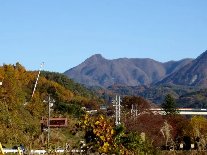
Mount Magari is a 1,642.8-meter peak straddling the boundary between Kai City and Hokuto City in Yamanashi Prefecture, lying in the southwestern part of the Oku-Chichibu mountains. Its name ("crooked peak") comes from the way the summit appears to lean conspicuously eastward when viewed from the Kōfu Basin; from the narrow summit, hikers enjoy panoramic views of Mt. Kinpu and the Oku-Chichibu range as well as Mt. Fuji. The azaleas of the so-called Magaridake Garden bloom near the summit in mid-June.
Magaridake at a glance
- Weather: The most settled day in the next 7 days is Sun, November 8: clear, gusts up to 8 m/s.
Magaridake weather (hourly, 14 days)
Sunrise today 06:09, sunset 16:50
| Tue, 11/3 | Wed, 11/4 | Thu, 11/5 | Fri, 11/6 | Sat, 11/7 | Sun, 11/8 | Mon, 11/9 | Tue, 11/10 | Wed, 11/11 | Thu, 11/12 | Fri, 11/13 | Sat, 11/14 | Sun, 11/15 | Mon, 11/16 | Tue, 11/17 | |||||||||||||||||||||||||||||||||||||||||||||||||||||||||||||||||||||||
|---|---|---|---|---|---|---|---|---|---|---|---|---|---|---|---|---|---|---|---|---|---|---|---|---|---|---|---|---|---|---|---|---|---|---|---|---|---|---|---|---|---|---|---|---|---|---|---|---|---|---|---|---|---|---|---|---|---|---|---|---|---|---|---|---|---|---|---|---|---|---|---|---|---|---|---|---|---|---|---|---|---|---|---|---|---|
| Japan time | 15 | 17 | 19 | 21 | 23 | 1 | 3 | 5 | 7 | 9 | 11 | 13 | 15 | 18 | 21 | 0 | 3 | 6 | 9 | 12 | 15 | 18 | 21 | 0 | 3 | 6 | 9 | 12 | 15 | 18 | 21 | 0 | 3 | 6 | 9 | 12 | 15 | 18 | 21 | 0 | 3 | 6 | 9 | 12 | 15 | 18 | 21 | 0 | 3 | 6 | 9 | 15 | 21 | 3 | 9 | 15 | 21 | 3 | 9 | 15 | 21 | 3 | 9 | 15 | 21 | 3 | 9 | 15 | 21 | 3 | 9 | 15 | 21 | 3 | 9 | 15 | 21 | 3 | 9 | 15 | 21 | 3 | 9 | 15 | |
  |   |   | | |   |   | |   |   | | | | | | | | | | |   |   |   |  | | |  | | | | | | | | | | | | | | | | | | | | | | | | |   | |   |   | | | |   | |   |  | | | | | | | | | | | | | | | | | | | | | | | ||
| Temperature | °C | 10° | 6° | 5° | 5° | 4° | 4° | 4° | 3° | 3° | 6° | 9° | 9° | 8° | 6° | 6° | 6° | 6° | 6° | 10° | 14° | 11° | 8° | 8° | 7° | 7° | 6° | 12° | 15° | 14° | 8° | 7° | 5° | 3° | 2° | 5° | 7° | 6° | 2° | 0° | 0° | 0° | -1° | 6° | 9° | 8° | 3° | 4° | 4° | 4° | 4° | 6° | 8° | 4° | 2° | 4° | 6° | 2° | 0° | 2° | 3° | -2° | -2° | 3° | 6° | 1° | -2° | 5° | 7° | -1° | -2° | 5° | 6° | 1° | 1° | 6° | 7° | 6° | 6° | 11° | 12° | 2° | 0° | 4° | 5° |
| Precipitation | mm | 0.2 | 0.4 | 0.1 | 0.1 | 4.1 | 9 | 4.7 | 2.1 | 0.3 | 0.1 | 0.2 | 3.7 | 4.3 | 1.8 | 0.5 | 0.3 | 7 | 10 | ||||||||||||||||||||||||||||||||||||||||||||||||||||||||||||||||||
| New snow | cm | 0.3 | 0.1 | <.1 | |||||||||||||||||||||||||||||||||||||||||||||||||||||||||||||||||||||||||||||||||
| Snow depth | cm | 0 | 0 | 0 | 0 | 0 | 0 | 0 | 0 | 0 | 0 | 0 | 0 | 0 | 0 | 0 | 0 | 0 | 0 | 0 | 0 | 0 | 0 | 0 | 0 | 0 | 0 | 0 | 0 | 0 | 0 | 0 | 0 | 0 | 0 | 0 | 0 | 0 | 0 | 0 | 0 | 0 | 0 | 0 | 0 | 0 | 0 | 0 | 0 | 0 | 0 | 0 | 0 | 0 | <1 | <1 | 0 | 0 | 0 | 0 | 0 | 0 | 0 | 0 | 0 | 0 | 0 | 0 | 0 | 0 | 0 | 0 | 0 | 0 | 0 | 0 | 0 | 0 | 0 | 0 | 0 | 0 | 0 | 0 | 0 |
| Wind | m/s | 2 | 0 | 1 | 1 | 1 | 1 | 0 | 1 | 1 | 2 | 2 | 2 | 2 | 1 | 0 | 0 | 0 | 1 | 1 | 2 | 1 | 0 | 0 | 1 | 1 | 2 | 3 | 4 | 3 | 3 | 3 | 4 | 3 | 3 | 4 | 4 | 4 | 3 | 2 | 1 | 1 | 1 | 1 | 2 | 1 | 1 | 1 | 1 | 1 | 1 | 1 | 1 | 1 | 1 | 2 | 2 | 1 | 4 | 6 | 5 | 3 | 1 | 2 | 2 | 0 | 2 | 3 | 3 | 3 | 2 | 1 | 1 | 0 | 1 | 1 | 2 | 2 | 0 | 1 | 5 | 4 | 1 | 2 | 2 |
| Wind gusts | m/s | 8 | 6 | 3 | 3 | 2 | 3 | 3 | 2 | 2 | 5 | 7 | 8 | 8 | 6 | 6 | 4 | 4 | 4 | 4 | 6 | 7 | 5 | 3 | 4 | 6 | 8 | 11 | 13 | 13 | 11 | 11 | 10 | 10 | 11 | 13 | 14 | 14 | 12 | 8 | 6 | 5 | 5 | 6 | 8 | 8 | 5 | 5 | 5 | 5 | 4 | 5 | 9 | 6 | 3 | 6 | 9 | 7 | 13 | 19 | 18 | 14 | 9 | 5 | 8 | 6 | 6 | 9 | 12 | 9 | 7 | 5 | 7 | 4 | 4 | 5 | 8 | 8 | 8 | 7 | 16 | 15 | 10 | 6 | 8 |
| Wind dir. | ↓ | ↓ | ↓ | ↓ | ↓ | ↓ | ↓ | ↓ | ↓ | ↓ | ↓ | ↓ | ↓ | ↓ | ↓ | ↓ | ↓ | ↓ | ↓ | ↓ | ↓ | ↓ | ↓ | ↓ | ↓ | ↓ | ↓ | ↓ | ↓ | ↓ | ↓ | ↓ | ↓ | ↓ | ↓ | ↓ | ↓ | ↓ | ↓ | ↓ | ↓ | ↓ | ↓ | ↓ | ↓ | ↓ | ↓ | ↓ | ↓ | ↓ | ↓ | ↓ | ↓ | ↓ | ↓ | ↓ | ↓ | ↓ | ↓ | ↓ | ↓ | ↓ | ↓ | ↓ | ↓ | ↓ | ↓ | ↓ | ↓ | ↓ | ↓ | ↓ | ↓ | ↓ | ↓ | ↓ | ↓ | ↓ | ↓ | ↓ | ↓ | ↓ | ↓ | ||
Huts, campsites and lodging near Magaridake
Campsites
- ノースランドキャンパーズビレッジ
- PICA八ヶ岳明野
Lists that include Magaridake
Magaridake facts
- Elevation
- 1,643 m
- Location
- Hokuto, Yamanashi / Kai, Yamanashi
35.802926, 138.536155 - Website
- www.city.kai.yamanashi.jp
- Wikipedia
- ja.wikipedia.org