
Kanagatake
金ヶ岳
Hokuto, Yamanashi · Elevation 1,764 m
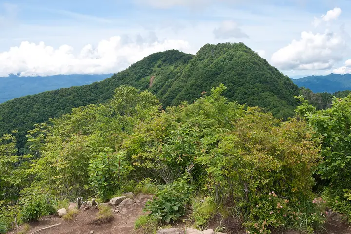
Kanagatake is a 1,764 m peak in Hokuto City, Yamanashi Prefecture, the highest point of the Kayagatake massif and connected by ridge to Kayagatake (1,704 m). The pair resembles Yatsugatake from below, earning the nickname Nise-Yatsu. Routes start at Akeno Fureai-no-Sato and Fukada Memorial Park, with about an hour between Kayagatake and Kanagatake. The summit offers views of Mount Fuji, the Southern and Northern Alps, and Yatsugatake.
Kanagatake at a glance
- Weather: The most settled day in the next 7 days is Sun, November 8: clear, gusts up to 8 m/s.
- Route: The shortest is Mount Kayagatake and Mount Kanegatake Fukada Memorial Park Out-and-Back: about 6 h 5 min, 9.0 km, about 1,090 m of climbing.
Kanagatake weather (hourly, 14 days)
Sunrise today 06:09, sunset 16:50
| Tue, 11/3 | Wed, 11/4 | Thu, 11/5 | Fri, 11/6 | Sat, 11/7 | Sun, 11/8 | Mon, 11/9 | Tue, 11/10 | Wed, 11/11 | Thu, 11/12 | Fri, 11/13 | Sat, 11/14 | Sun, 11/15 | Mon, 11/16 | Tue, 11/17 | |||||||||||||||||||||||||||||||||||||||||||||||||||||||||||||||||||||||
|---|---|---|---|---|---|---|---|---|---|---|---|---|---|---|---|---|---|---|---|---|---|---|---|---|---|---|---|---|---|---|---|---|---|---|---|---|---|---|---|---|---|---|---|---|---|---|---|---|---|---|---|---|---|---|---|---|---|---|---|---|---|---|---|---|---|---|---|---|---|---|---|---|---|---|---|---|---|---|---|---|---|---|---|---|---|
| Japan time | 15 | 17 | 19 | 21 | 23 | 1 | 3 | 5 | 7 | 9 | 11 | 13 | 15 | 18 | 21 | 0 | 3 | 6 | 9 | 12 | 15 | 18 | 21 | 0 | 3 | 6 | 9 | 12 | 15 | 18 | 21 | 0 | 3 | 6 | 9 | 12 | 15 | 18 | 21 | 0 | 3 | 6 | 9 | 12 | 15 | 18 | 21 | 0 | 3 | 6 | 9 | 15 | 21 | 3 | 9 | 15 | 21 | 3 | 9 | 15 | 21 | 3 | 9 | 15 | 21 | 3 | 9 | 15 | 21 | 3 | 9 | 15 | 21 | 3 | 9 | 15 | 21 | 3 | 9 | 15 | 21 | 3 | 9 | 15 | |
  |   |   | | |   |   | |   |   | | | | | | | | | | |   |   |   |  | | |  | | | | | | | | | | | | | | | | | | | | | | | | |   | |   |   | | | |   | |   |  | | | | | | | | | | | | | | | | | | | | | | | ||
| Temperature | °C | 9° | 5° | 5° | 4° | 3° | 3° | 3° | 2° | 3° | 5° | 8° | 8° | 7° | 5° | 5° | 5° | 6° | 5° | 9° | 14° | 10° | 7° | 7° | 7° | 6° | 6° | 11° | 14° | 13° | 8° | 6° | 4° | 2° | 2° | 5° | 6° | 6° | 1° | -1° | -1° | -1° | -2° | 5° | 8° | 8° | 2° | 3° | 3° | 3° | 3° | 6° | 7° | 3° | 2° | 3° | 5° | 1° | -1° | 1° | 2° | -3° | -3° | 3° | 5° | 0° | -2° | 5° | 6° | -2° | -3° | 4° | 6° | 0° | 0° | 5° | 6° | 5° | 5° | 10° | 12° | 1° | 0° | 3° | 4° |
| Precipitation | mm | 0.2 | 0.4 | 0.1 | 0.1 | 4.1 | 9 | 4.7 | 2.1 | 0.3 | 0.1 | 0.2 | 3.7 | 4.3 | 1.8 | 0.5 | 0.3 | 7 | 10 | ||||||||||||||||||||||||||||||||||||||||||||||||||||||||||||||||||
| New snow | cm | 0.3 | 0.1 | <.1 | |||||||||||||||||||||||||||||||||||||||||||||||||||||||||||||||||||||||||||||||||
| Snow depth | cm | 0 | 0 | 0 | 0 | 0 | 0 | 0 | 0 | 0 | 0 | 0 | 0 | 0 | 0 | 0 | 0 | 0 | 0 | 0 | 0 | 0 | 0 | 0 | 0 | 0 | 0 | 0 | 0 | 0 | 0 | 0 | 0 | 0 | 0 | 0 | 0 | 0 | 0 | 0 | 0 | 0 | 0 | 0 | 0 | 0 | 0 | 0 | 0 | 0 | 0 | 0 | 0 | 0 | <1 | <1 | 0 | 0 | 0 | 0 | 0 | 0 | 0 | 0 | 0 | 0 | 0 | 0 | 0 | 0 | 0 | 0 | 0 | 0 | 0 | 0 | 0 | 0 | 0 | 0 | 0 | 0 | 0 | 0 | 0 |
| Wind | m/s | 2 | 0 | 1 | 1 | 1 | 1 | 0 | 1 | 1 | 2 | 2 | 2 | 2 | 1 | 0 | 0 | 0 | 1 | 1 | 2 | 1 | 0 | 0 | 1 | 1 | 2 | 3 | 4 | 3 | 3 | 3 | 4 | 3 | 3 | 4 | 4 | 4 | 3 | 2 | 1 | 1 | 1 | 1 | 2 | 1 | 1 | 1 | 1 | 1 | 1 | 1 | 1 | 1 | 1 | 2 | 2 | 1 | 4 | 6 | 5 | 3 | 1 | 2 | 2 | 0 | 2 | 3 | 3 | 3 | 2 | 1 | 1 | 0 | 1 | 1 | 2 | 2 | 0 | 1 | 5 | 4 | 1 | 2 | 2 |
| Wind gusts | m/s | 8 | 6 | 3 | 3 | 2 | 3 | 3 | 2 | 2 | 5 | 7 | 8 | 8 | 6 | 6 | 4 | 4 | 4 | 4 | 6 | 7 | 5 | 3 | 4 | 6 | 8 | 11 | 13 | 13 | 11 | 11 | 10 | 10 | 11 | 13 | 14 | 14 | 12 | 8 | 6 | 5 | 5 | 6 | 8 | 8 | 5 | 5 | 5 | 5 | 4 | 5 | 9 | 6 | 3 | 6 | 9 | 7 | 13 | 19 | 18 | 14 | 9 | 5 | 8 | 6 | 6 | 9 | 12 | 9 | 7 | 5 | 7 | 4 | 4 | 5 | 8 | 8 | 8 | 7 | 16 | 15 | 10 | 6 | 8 |
| Wind dir. | ↓ | ↓ | ↓ | ↓ | ↓ | ↓ | ↓ | ↓ | ↓ | ↓ | ↓ | ↓ | ↓ | ↓ | ↓ | ↓ | ↓ | ↓ | ↓ | ↓ | ↓ | ↓ | ↓ | ↓ | ↓ | ↓ | ↓ | ↓ | ↓ | ↓ | ↓ | ↓ | ↓ | ↓ | ↓ | ↓ | ↓ | ↓ | ↓ | ↓ | ↓ | ↓ | ↓ | ↓ | ↓ | ↓ | ↓ | ↓ | ↓ | ↓ | ↓ | ↓ | ↓ | ↓ | ↓ | ↓ | ↓ | ↓ | ↓ | ↓ | ↓ | ↓ | ↓ | ↓ | ↓ | ↓ | ↓ | ↓ | ↓ | ↓ | ↓ | ↓ | ↓ | ↓ | ↓ | ↓ | ↓ | ↓ | ↓ | ↓ | ↓ | ↓ | ↓ | ||
Kanagatake hiking routes
- Mount Kayagatake and Mount Kanegatake Fukada Memorial Park Out-and-Back 9.0 km · Ascent 1,087 m 深田記念公園駐車場
- Hokuto Circuit Linking Mount Kaya and Mount Kana, Called Fake Yatsu for Their Likeness to Yatsugatake, from the Memorial Park 13.0 km · Ascent 1,116 m 深田記念公園駐車場
Hiking times are estimates calculated from the terrain.
Huts, campsites and lodging near Kanagatake
Campsites
- ノースランドキャンパーズビレッジ
- PICA八ヶ岳明野
Kanagatake facts
- Also known as
- 金ヶ岳北峰
- Elevation
- 1,764 m
- Location
- Hokuto, Yamanashi
35.803170, 138.509365 - Website
- www.city.hokuto.yamanashi.jp
- Trail Map
- www.city.hokuto.yamanashi.jp (PDF)
- Access Information
- www.hokuto-kanko.jp
- Wikipedia
- ja.wikipedia.org