
Sanbonyaridake
三本槍岳
Nasushiobara, Tochigi / Nishigō-mura, Fukushima · Elevation 1,917 m
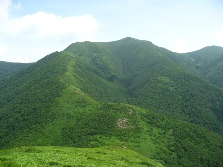
Sanbonyaridake is a 1,916.9 m stratovolcano on the border between Nishigo Village in Fukushima and Nasushiobara City in Tochigi, the highest peak in the Nasu area. It lies in Nikko National Park and formed through volcanic activity older than that of Chausudake and Asahidake. Despite its name, meaning three spears, its broad summit is gentle and grassy, with panoramic views toward Aizu, Nikko and Oze. Common approaches traverse from the Nasu Ropeway via Chausudake and Asahidake or climb from Kashi Onsen on the Nishigo side.
Sanbonyaridake at a glance
- Weather: The most settled day in the next 7 days is Wed, November 4: clear, gusts up to 9 m/s. Fri, Nov 6, Sat, Nov 7, Sun, Nov 8: strong wind (gusts up to 23 m/s).
- Route: The shortest is Nasu Three-Peak Traverse: Ropeway Summit Station to Toge-no-Chaya: about 6 h 19 min, 10.6 km, about 770 m of climbing.
Sanbonyaridake weather (hourly, 14 days)
Sunrise today 06:06, sunset 16:42
| Tue, 11/3 | Wed, 11/4 | Thu, 11/5 | Fri, 11/6 | Sat, 11/7 | Sun, 11/8 | Mon, 11/9 | Tue, 11/10 | Wed, 11/11 | Thu, 11/12 | Fri, 11/13 | Sat, 11/14 | Sun, 11/15 | Mon, 11/16 | Tue, 11/17 | |||||||||||||||||||||||||||||||||||||||||||||||||||||||||||||||||||||||
|---|---|---|---|---|---|---|---|---|---|---|---|---|---|---|---|---|---|---|---|---|---|---|---|---|---|---|---|---|---|---|---|---|---|---|---|---|---|---|---|---|---|---|---|---|---|---|---|---|---|---|---|---|---|---|---|---|---|---|---|---|---|---|---|---|---|---|---|---|---|---|---|---|---|---|---|---|---|---|---|---|---|---|---|---|---|
| Japan time | 15 | 17 | 19 | 21 | 23 | 1 | 3 | 5 | 7 | 9 | 11 | 13 | 15 | 18 | 21 | 0 | 3 | 6 | 9 | 12 | 15 | 18 | 21 | 0 | 3 | 6 | 9 | 12 | 15 | 18 | 21 | 0 | 3 | 6 | 9 | 12 | 15 | 18 | 21 | 0 | 3 | 6 | 9 | 12 | 15 | 18 | 21 | 0 | 3 | 6 | 9 | 15 | 21 | 3 | 9 | 15 | 21 | 3 | 9 | 15 | 21 | 3 | 9 | 15 | 21 | 3 | 9 | 15 | 21 | 3 | 9 | 15 | 21 | 3 | 9 | 15 | 21 | 3 | 9 | 15 | 21 | 3 | 9 | 15 | |
 |   | |  | | | | | | | | |   |   |   | | | |   | |   | | | |   | |   |   |   | | | | | |   | | |   | |   | | | | | | | | | | | | | | | | | | |   | | | | | |  | | | |   | | | | | | | | |   | | | | | | | ||
| Temperature | °C | 5° | 1° | -1° | -2° | -1° | -2° | -2° | -2° | 0° | 5° | 7° | 8° | 6° | 2° | 2° | 2° | 4° | 4° | 6° | 8° | 8° | 6° | 6° | 5° | 3° | 4° | 8° | 9° | 9° | 5° | 3° | 1° | 0° | -1° | -2° | -2° | -2° | -3° | -3° | -3° | -3° | -3° | -2° | 1° | 0° | -2° | -2° | -2° | -2° | -3° | 0° | 3° | -2° | -3° | 1° | 3° | -3° | -2° | -2° | -1° | -2° | -3° | 0° | 2° | -3° | -1° | -1° | -1° | -4° | -4° | 0° | 4° | -4° | -3° | 5° | 6° | 3° | 4° | 9° | 3° | -3° | -4° | -1° | 2° |
| Precipitation | mm | 0.3 | 0.3 | 8 | 9 | 8 | 1.4 | 0.1 | 0.8 | 0.3 | 0.2 | 0.5 | 0.7 | 0.3 | 0.6 | 1.6 | 1.8 | 1.1 | 0.6 | 0.5 | 0.2 | 0.4 | 0.4 | 0.2 | 0.1 | 0.1 | 0.9 | 2.3 | 1.4 | 0.9 | 0.3 | 2.2 | 0.1 | 3.1 | 8 | 2.3 | 2.3 | 0.2 | |||||||||||||||||||||||||||||||||||||||||||||||
| New snow | cm | 0.6 | 0.9 | 0.5 | 0.3 | 0.4 | <.1 | <.1 | 0.1 | 0.1 | <.1 | <.1 | <.1 | <.1 | 2.1 | 0.2 | <.1 | 0.1 | |||||||||||||||||||||||||||||||||||||||||||||||||||||||||||||||||||
| Snow depth | cm | 0 | 0 | 0 | 0 | 0 | 0 | 0 | 0 | 0 | 0 | 0 | 0 | 0 | 0 | 0 | 0 | 0 | 0 | 0 | 0 | 0 | 0 | 0 | 0 | 0 | 0 | 0 | 0 | 0 | 0 | 0 | 0 | 0 | 0 | <1 | <1 | <1 | <1 | <1 | <1 | <1 | <1 | <1 | <1 | <1 | <1 | 0 | 0 | 0 | 0 | 0 | 0 | 0 | 0 | 0 | 0 | 0 | 0 | <1 | 0 | 0 | 0 | 0 | 0 | 0 | 0 | 0 | 0 | 0 | 0 | 0 | 0 | 0 | 0 | 0 | 0 | 0 | 0 | 0 | 0 | 0 | 0 | 0 | 0 |
| Wind | m/s | 5 | 3 | 2 | 2 | 2 | 2 | 2 | 2 | 2 | 1 | 1 | 2 | 3 | 2 | 3 | 2 | 2 | 0 | 1 | 2 | 2 | 1 | 2 | 1 | 1 | 2 | 5 | 6 | 6 | 4 | 4 | 5 | 7 | 5 | 4 | 6 | 6 | 6 | 6 | 5 | 5 | 4 | 5 | 6 | 6 | 3 | 2 | 2 | 2 | 2 | 1 | 1 | 2 | 2 | 1 | 4 | 1 | 4 | 7 | 8 | 5 | 3 | 3 | 3 | 1 | 3 | 6 | 7 | 4 | 3 | 2 | 0 | 1 | 0 | 1 | 1 | 0 | 1 | 2 | 5 | 8 | 4 | 2 | 0 |
| Wind gusts | m/s | 18 | 15 | 10 | 9 | 8 | 8 | 7 | 7 | 7 | 7 | 4 | 7 | 9 | 9 | 10 | 11 | 10 | 7 | 7 | 6 | 6 | 5 | 6 | 6 | 6 | 10 | 16 | 19 | 19 | 18 | 16 | 16 | 21 | 22 | 18 | 21 | 23 | 23 | 20 | 20 | 19 | 19 | 17 | 19 | 19 | 17 | 11 | 8 | 7 | 7 | 7 | 6 | 7 | 7 | 6 | 12 | 12 | 13 | 23 | 27 | 25 | 15 | 11 | 12 | 10 | 9 | 19 | 22 | 21 | 14 | 12 | 7 | 6 | 6 | 5 | 7 | 6 | 10 | 9 | 18 | 23 | 23 | 14 | 7 |
| Wind dir. | ↓ | ↓ | ↓ | ↓ | ↓ | ↓ | ↓ | ↓ | ↓ | ↓ | ↓ | ↓ | ↓ | ↓ | ↓ | ↓ | ↓ | ↓ | ↓ | ↓ | ↓ | ↓ | ↓ | ↓ | ↓ | ↓ | ↓ | ↓ | ↓ | ↓ | ↓ | ↓ | ↓ | ↓ | ↓ | ↓ | ↓ | ↓ | ↓ | ↓ | ↓ | ↓ | ↓ | ↓ | ↓ | ↓ | ↓ | ↓ | ↓ | ↓ | ↓ | ↓ | ↓ | ↓ | ↓ | ↓ | ↓ | ↓ | ↓ | ↓ | ↓ | ↓ | ↓ | ↓ | ↓ | ↓ | ↓ | ↓ | ↓ | ↓ | ↓ | ↓ | ↓ | ↓ | ↓ | ↓ | ↓ | ↓ | ↓ | ↓ | ↓ | ↓ | ↓ | ↓ | |
Sanbonyaridake hiking routes
Hiking times are estimates calculated from the terrain.
Huts, campsites and lodging near Sanbonyaridake
Mountain huts
- 三斗小屋温泉 煙草屋旅館 2026: open April 18–November 30 · reservation required
- 三斗小屋温泉 大黒屋 2026: open April 11–November 25 · reservation required
- 那須岳避難小屋
- 峰の茶屋跡避難小屋 unstaffed · sleeps 30
- Bozunuma Emergency Shelter unstaffed · sleeps 20
Campsites
- 休暇村那須キャンプ場
Lodging
- 大丸温泉旅館
- 旅館ニューおおたか
- 那須マウントホテル
- 弁天温泉旅館
- 北温泉
Lists that include Sanbonyaridake
100 Famous Mountains with First-order Triangulation Points · Kanto 100 Famous Mountains · Tohoku 100 Famous Mountains · Tochigi 100 Famous Mountains · Utsukushima 100 Famous Mountains (Fukushima Prefecture) · Aizu 100 Famous Mountains · 30 Peaks of Fukushima · Nasu 5 Peaks · Elevations of 1003 Mountains of Japan · 1000 Mountains of Japan
Sanbonyaridake facts
- Elevation
- 1,917 m
- Location
- Nasushiobara, Tochigi / Nishigō-mura, Fukushima
37.150094, 139.961459 - National Park
- 日光国立公園
- Website
- www.env.go.jp
- Trail Map
- www.town.nasu.lg.jp (PDF)
- Wikipedia
- ja.wikipedia.org