
Ō-Asahidake
大朝日岳
Asahi, Yamagata / Oguni, Yamagata · Elevation 1,870 m
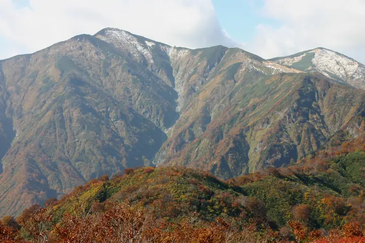
Ō-Asahidake, at 1,870 m, is the principal peak of the Asahi Range spanning Yamagata and Niigata, with its summit on the boundary of Asahi and Oguni towns within Yamagata Prefecture. It lies in Bandai-Asahi National Park, with a main ridge extending roughly 15 km via Nishiasahidake and Ryumonzan to Itodake. Snowbed plant communities and alpine flowers flourish along the ridge. Trails begin at Kodera Kosen, Asahi Kosen and Higurezawa, and Oasahi Hut provides emergency shelter just below the summit.
Ō-Asahidake at a glance
- Weather: The most settled day in the next 7 days is Mon, November 9: cloudy, gusts up to 7 m/s. Fri, Nov 6, Sat, Nov 7, Sun, Nov 8: strong wind (gusts up to 22 m/s).
- Route: The shortest is Mount Ōasahi from Koderakōsen Trailhead: about 10 h 45 min, 16.7 km, about 1,620 m of climbing.
Ō-Asahidake weather (hourly, 14 days)
Sunrise today 06:08, sunset 16:40
| Tue, 11/3 | Wed, 11/4 | Thu, 11/5 | Fri, 11/6 | Sat, 11/7 | Sun, 11/8 | Mon, 11/9 | Tue, 11/10 | Wed, 11/11 | Thu, 11/12 | Fri, 11/13 | Sat, 11/14 | Sun, 11/15 | Mon, 11/16 | Tue, 11/17 | |||||||||||||||||||||||||||||||||||||||||||||||||||||||||||||||||||||||
|---|---|---|---|---|---|---|---|---|---|---|---|---|---|---|---|---|---|---|---|---|---|---|---|---|---|---|---|---|---|---|---|---|---|---|---|---|---|---|---|---|---|---|---|---|---|---|---|---|---|---|---|---|---|---|---|---|---|---|---|---|---|---|---|---|---|---|---|---|---|---|---|---|---|---|---|---|---|---|---|---|---|---|---|---|---|
| Japan time | 15 | 17 | 19 | 21 | 23 | 1 | 3 | 5 | 7 | 9 | 11 | 13 | 15 | 18 | 21 | 0 | 3 | 6 | 9 | 12 | 15 | 18 | 21 | 0 | 3 | 6 | 9 | 12 | 15 | 18 | 21 | 0 | 3 | 6 | 9 | 12 | 15 | 18 | 21 | 0 | 3 | 6 | 9 | 12 | 15 | 18 | 21 | 0 | 3 | 6 | 9 | 15 | 21 | 3 | 9 | 15 | 21 | 3 | 9 | 15 | 21 | 3 | 9 | 15 | 21 | 3 | 9 | 15 | 21 | 3 | 9 | 15 | 21 | 3 | 9 | 15 | 21 | 3 | 9 | 15 | 21 | 3 | 9 | 15 | |
 |  |   | | | | | |   | | |   | | | |   |   | |   | | | | | | | | | | | | |   | | |   | | |   | | | | | | | | |   | | | |   | |   |   | | | | |   | | | |   | |   | | | | | | | |  | | | | | | | | | | | | ||
| Temperature | °C | 2° | -2° | -4° | -4° | -4° | -4° | -4° | -3° | -1° | 3° | 5° | 6° | 5° | 0° | 0° | 1° | 1° | 2° | 3° | 4° | 5° | 4° | 4° | 4° | 4° | 5° | 6° | 6° | 4° | 2° | 0° | -2° | -4° | -4° | -4° | -4° | -4° | -5° | -5° | -5° | -5° | -5° | -4° | -3° | -3° | -5° | -5° | -6° | -5° | -7° | -3° | -3° | -6° | -9° | -2° | 0° | -4° | -5° | -3° | -2° | -4° | -5° | -3° | -2° | -4° | -2° | -3° | -3° | -5° | -6° | -1° | 2° | -4° | -4° | 5° | 6° | 1° | 2° | 4° | 0° | -6° | -6° | -3° | -2° |
| Precipitation | mm | 1.0 | 10 | 4.6 | 3.6 | 0.4 | 0.4 | 1.2 | 1.1 | 4.0 | 3.1 | 1.3 | 3.3 | 2.3 | 4.6 | 5 | 5 | 3.7 | 3.5 | 1.3 | 2.1 | 3.0 | 2.6 | 2.7 | 1.6 | 1.1 | 0.8 | 0.2 | 0.7 | 0.3 | 0.4 | 0.1 | 0.1 | 1.9 | 9 | 3.2 | 0.3 | 0.8 | 0.2 | 0.6 | 1.8 | 0.7 | 5 | 2.5 | 0.1 | 0.1 | 3.1 | 8 | 3.8 | 3.5 | 2.3 | 0.2 | |||||||||||||||||||||||||||||||||
| New snow | cm | <.1 | 2.3 | 3.8 | 3.4 | 3.2 | 1.2 | 2.0 | 2.9 | 2.5 | 2.6 | 1.5 | 1.0 | 0.7 | 0.1 | 0.6 | 0.3 | 0.3 | <.1 | <.1 | 0.6 | 3.5 | 2.9 | <.1 | 0.1 | <.1 | 0.2 | <.1 | 0.1 | 0.2 | 0.2 | <.1 | |||||||||||||||||||||||||||||||||||||||||||||||||||||
| Snow depth | cm | 0 | 0 | 0 | 0 | 0 | 0 | 0 | 0 | 0 | 0 | 0 | 0 | 0 | 0 | 0 | 0 | 0 | 0 | 0 | 0 | 0 | 0 | 0 | 0 | 0 | 0 | 0 | 0 | 0 | 0 | 0 | 0 | 1 | 3 | 5 | 7 | 7 | 8 | 9 | 11 | 12 | 12 | 13 | 12 | 11 | 11 | 11 | 11 | 11 | 11 | 11 | 9 | 9 | 9 | 9 | 7 | 7 | 8 | 10 | 7 | 6 | 6 | 5 | 3 | 3 | 3 | 2 | <1 | 1 | 1 | <1 | <1 | <1 | <1 | <1 | <1 | 0 | 0 | 0 | 0 | 0 | <1 | <1 | 0 |
| Wind | m/s | 4 | 2 | 2 | 2 | 1 | 1 | 2 | 2 | 2 | 2 | 2 | 1 | 2 | 1 | 1 | 2 | 2 | 1 | 1 | 1 | 1 | 1 | 1 | 1 | 2 | 3 | 4 | 6 | 5 | 4 | 4 | 4 | 3 | 4 | 4 | 4 | 5 | 5 | 5 | 5 | 5 | 5 | 5 | 6 | 5 | 3 | 2 | 2 | 2 | 1 | 1 | 1 | 1 | 1 | 1 | 3 | 2 | 2 | 3 | 4 | 3 | 2 | 2 | 2 | 1 | 2 | 5 | 5 | 3 | 2 | 2 | 1 | 0 | 2 | 2 | 1 | 1 | 1 | 2 | 6 | 5 | 4 | 3 | 2 |
| Wind gusts | m/s | 15 | 12 | 7 | 7 | 7 | 6 | 6 | 7 | 6 | 8 | 8 | 7 | 6 | 7 | 6 | 7 | 7 | 7 | 5 | 5 | 6 | 4 | 6 | 7 | 8 | 10 | 13 | 19 | 18 | 16 | 14 | 14 | 14 | 15 | 17 | 19 | 22 | 20 | 17 | 16 | 16 | 17 | 17 | 18 | 18 | 15 | 10 | 8 | 8 | 8 | 6 | 7 | 7 | 6 | 6 | 9 | 11 | 12 | 10 | 15 | 14 | 9 | 7 | 9 | 7 | 10 | 14 | 16 | 15 | 10 | 8 | 8 | 4 | 6 | 7 | 8 | 7 | 7 | 8 | 19 | 20 | 15 | 11 | 8 |
| Wind dir. | ↓ | ↓ | ↓ | ↓ | ↓ | ↓ | ↓ | ↓ | ↓ | ↓ | ↓ | ↓ | ↓ | ↓ | ↓ | ↓ | ↓ | ↓ | ↓ | ↓ | ↓ | ↓ | ↓ | ↓ | ↓ | ↓ | ↓ | ↓ | ↓ | ↓ | ↓ | ↓ | ↓ | ↓ | ↓ | ↓ | ↓ | ↓ | ↓ | ↓ | ↓ | ↓ | ↓ | ↓ | ↓ | ↓ | ↓ | ↓ | ↓ | ↓ | ↓ | ↓ | ↓ | ↓ | ↓ | ↓ | ↓ | ↓ | ↓ | ↓ | ↓ | ↓ | ↓ | ↓ | ↓ | ↓ | ↓ | ↓ | ↓ | ↓ | ↓ | ↓ | ↓ | ↓ | ↓ | ↓ | ↓ | ↓ | ↓ | ↓ | ↓ | ↓ | ↓ | ↓ | |
Ō-Asahidake hiking routes
Hiking times are estimates calculated from the terrain.
Huts, campsites and lodging near Ō-Asahidake
Mountain huts
Lists that include Ō-Asahidake
100 Famous Japanese Mountains · Japan 200 Famous Mountains · Japan's 300 Famous Mountains · New Japan 100 Famous Mountains · Tohoku 100 Famous Mountains · Yamagata 100 Famous Mountains · Elevations of 1003 Mountains of Japan · 1000 Mountains of Japan
Ō-Asahidake facts
- Also known as
- 古名:剣頭山(けんとうさん)
- Elevation
- 1,870 m
- Location
- Asahi, Yamagata / Oguni, Yamagata
38.260550, 139.922326 - National Park
- 磐梯朝日国立公園
- Website
- oekanko.jp
- Trail Map
- oekanko.jp (PDF)
- Wikipedia
- ja.wikipedia.org