
Mt. Yaguradake
矢倉岳
Minamiashigara, Kanagawa · Elevation 870 m
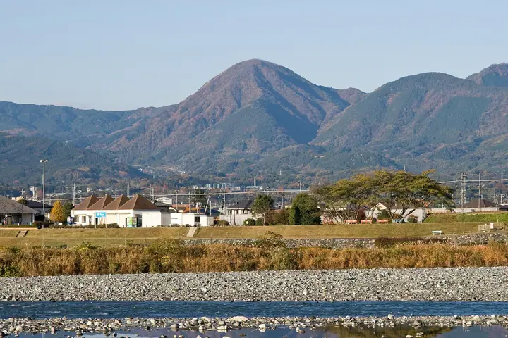
Mount Yaguradake (870 m) is a striking rice-ball-shaped peak in Yagurasawa, Minami-Ashigara City, Kanagawa, on the northern Ashigara Mountains just north of Mount Kintoki. Its name comes from the watchtower (yagura) it suggests above the old Ashigara Pass. Made of quartz diorite intruded about 1.15 million years ago and uplifted at one of the world's fastest rates, it is recognised as a Hakone Geopark geosite. The summit offers a 360° panorama including Mount Fuji, Hakone and Sagami Bay, and is one of the Three Mountains of Ashigara.
Mt. Yaguradake at a glance
- Weather: The most settled day in the next 7 days is Fri, November 6: clear, gusts up to 7 m/s.
- Route: The shortest is Minamiashigara Return from the Old Ashigara Road Hamlet up the Stream to Mount Yagura's Grassy Upturned-bowl Summit: about 4 h 24 min, 7.5 km, about 670 m of climbing.
Mt. Yaguradake weather (hourly, 14 days)
Sunrise today 06:06, sunset 16:49
| Tue, 11/3 | Wed, 11/4 | Thu, 11/5 | Fri, 11/6 | Sat, 11/7 | Sun, 11/8 | Mon, 11/9 | Tue, 11/10 | Wed, 11/11 | Thu, 11/12 | Fri, 11/13 | Sat, 11/14 | Sun, 11/15 | Mon, 11/16 | Tue, 11/17 | |||||||||||||||||||||||||||||||||||||||||||||||||||||||||||||||||||||||
|---|---|---|---|---|---|---|---|---|---|---|---|---|---|---|---|---|---|---|---|---|---|---|---|---|---|---|---|---|---|---|---|---|---|---|---|---|---|---|---|---|---|---|---|---|---|---|---|---|---|---|---|---|---|---|---|---|---|---|---|---|---|---|---|---|---|---|---|---|---|---|---|---|---|---|---|---|---|---|---|---|---|---|---|---|---|
| Japan time | 15 | 17 | 19 | 21 | 23 | 1 | 3 | 5 | 7 | 9 | 11 | 13 | 15 | 18 | 21 | 0 | 3 | 6 | 9 | 12 | 15 | 18 | 21 | 0 | 3 | 6 | 9 | 12 | 15 | 18 | 21 | 0 | 3 | 6 | 9 | 12 | 15 | 18 | 21 | 0 | 3 | 6 | 9 | 12 | 15 | 18 | 21 | 0 | 3 | 6 | 9 | 15 | 21 | 3 | 9 | 15 | 21 | 3 | 9 | 15 | 21 | 3 | 9 | 15 | 21 | 3 | 9 | 15 | 21 | 3 | 9 | 15 | 21 | 3 | 9 | 15 | 21 | 3 | 9 | 15 | 21 | 3 | 9 | 15 | |
  |   | | | | | | |   | | | | |   | | | | |   |   | | |   | | |   |  | | |  | | |   | | |   | |   | | | | |   | | | | | | | | | | | | | | | | | |   |  | | | | | | | | | | | | | | | | | | | | | | | ||
| Temperature | °C | 12° | 10° | 10° | 9° | 9° | 9° | 8° | 8° | 7° | 9° | 10° | 9° | 8° | 7° | 7° | 7° | 7° | 8° | 11° | 16° | 14° | 11° | 9° | 7° | 6° | 7° | 14° | 17° | 16° | 11° | 8° | 10° | 9° | 7° | 11° | 11° | 10° | 8° | 6° | 6° | 5° | 4° | 8° | 10° | 9° | 7° | 6° | 6° | 6° | 6° | 7° | 9° | 6° | 5° | 7° | 8° | 5° | 4° | 8° | 11° | 1° | 1° | 6° | 7° | 6° | 2° | 9° | 10° | 4° | 3° | 4° | 7° | 4° | 2° | 9° | 12° | 9° | 9° | 13° | 16° | 8° | 5° | 5° | 6° |
| Precipitation | mm | 0.2 | 0.2 | 0.2 | 0.8 | 2.4 | 6 | 10 | 17 | 8 | 1.2 | 0.2 | 1.2 | 0.4 | 0.6 | 1.3 | 1.4 | 0.2 | 0.4 | 0.5 | 0.6 | 0.1 | 0.3 | 0.2 | 12 | 22 | 1.7 | 0.2 | 0.8 | 0.6 | |||||||||||||||||||||||||||||||||||||||||||||||||||||||
| New snow | cm | ||||||||||||||||||||||||||||||||||||||||||||||||||||||||||||||||||||||||||||||||||||
| Snow depth | cm | 0 | 0 | 0 | 0 | 0 | 0 | 0 | 0 | 0 | 0 | 0 | 0 | 0 | 0 | 0 | 0 | 0 | 0 | 0 | 0 | 0 | 0 | 0 | 0 | 0 | 0 | 0 | 0 | 0 | 0 | 0 | 0 | 0 | 0 | 0 | 0 | 0 | 0 | 0 | 0 | 0 | 0 | 0 | 0 | 0 | 0 | 0 | 0 | 0 | 0 | 0 | 0 | 0 | 0 | 0 | 0 | 0 | 0 | 0 | 0 | 0 | 0 | 0 | 0 | 0 | 0 | 0 | 0 | 0 | 0 | 0 | 0 | 0 | 0 | 0 | 0 | 0 | 0 | 0 | 0 | 0 | 0 | 0 | 0 |
| Wind | m/s | 2 | 1 | 1 | 0 | 1 | 1 | 1 | 1 | 1 | 2 | 2 | 2 | 2 | 2 | 2 | 3 | 2 | 3 | 3 | 2 | 2 | 0 | 0 | 0 | 1 | 1 | 0 | 2 | 1 | 1 | 1 | 1 | 1 | 1 | 1 | 3 | 2 | 1 | 0 | 0 | 0 | 0 | 1 | 2 | 2 | 0 | 1 | 0 | 1 | 1 | 1 | 2 | 1 | 2 | 2 | 3 | 0 | 1 | 3 | 3 | 1 | 0 | 1 | 2 | 1 | 1 | 1 | 2 | 0 | 1 | 1 | 2 | 1 | 1 | 1 | 3 | 1 | 1 | 1 | 2 | 1 | 1 | 1 | 2 |
| Wind gusts | m/s | 8 | 6 | 2 | 2 | 2 | 2 | 3 | 3 | 3 | 5 | 5 | 6 | 6 | 5 | 5 | 6 | 8 | 7 | 7 | 8 | 6 | 4 | 2 | 3 | 4 | 4 | 4 | 6 | 7 | 4 | 4 | 3 | 5 | 4 | 4 | 8 | 8 | 6 | 2 | 2 | 2 | 1 | 4 | 7 | 7 | 6 | 3 | 3 | 2 | 2 | 4 | 8 | 6 | 5 | 5 | 8 | 7 | 3 | 15 | 13 | 7 | 4 | 4 | 7 | 5 | 3 | 4 | 9 | 6 | 3 | 4 | 6 | 5 | 3 | 5 | 10 | 7 | 8 | 5 | 7 | 5 | 5 | 4 | 7 |
| Wind dir. | ↓ | ↓ | ↓ | ↓ | ↓ | ↓ | ↓ | ↓ | ↓ | ↓ | ↓ | ↓ | ↓ | ↓ | ↓ | ↓ | ↓ | ↓ | ↓ | ↓ | ↓ | ↓ | ↓ | ↓ | ↓ | ↓ | ↓ | ↓ | ↓ | ↓ | ↓ | ↓ | ↓ | ↓ | ↓ | ↓ | ↓ | ↓ | ↓ | ↓ | ↓ | ↓ | ↓ | ↓ | ↓ | ↓ | ↓ | ↓ | ↓ | ↓ | ↓ | ↓ | ↓ | ↓ | ↓ | ↓ | ↓ | ↓ | ↓ | ↓ | ↓ | ↓ | ↓ | ↓ | ↓ | ↓ | ↓ | ↓ | ↓ | ↓ | ↓ | ↓ | ↓ | ↓ | ↓ | ↓ | ↓ | ↓ | ↓ | ↓ | ↓ | ↓ | ↓ | ↓ | |
Mt. Yaguradake hiking routes
Hiking times are estimates calculated from the terrain.
Huts, campsites and lodging near Mt. Yaguradake
Campsites
- sotosotodays CAMPGROUNDS
- CAMPiece南足柄
Lodging
- 一棟貸し民家 おこもりステイ「こもりび」
Lists that include Mt. Yaguradake
Mt. Yaguradake facts
- Also known as
- 竹の越し · カケ山
- Elevation
- 870 m
- Location
- Minamiashigara, Kanagawa
35.328615, 139.035367 - Access Information
- www.city.minamiashigara.kanagawa.jp
- Wikipedia
- ja.wikipedia.org