
Mt. Shidango
シダンゴ山
Matsuda, Kanagawa · Elevation 758 m
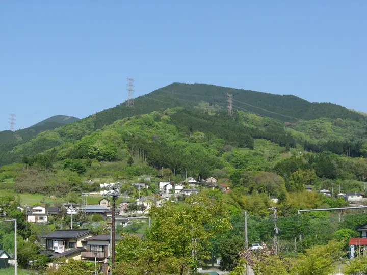
Mt. Shidango (758 m) rises in Matsuda Town, Ashigara-kami District, Kanagawa, on the southern Tanzawa Range within Tanzawa-Ōyama Quasi-National Park. Its unusual name is said to derive from "Shidagon," a Buddhist figure once enshrined on the summit during Buddhism's introduction to Japan, and the peak is also known as Shintan-gō-yama or Yori-Gongen-yama. The broad, open summit gives a 360-degree view sweeping over the main Tanzawa ridge, Mt. Fuji, and Sagami Bay, with Japanese andromeda blooming below the top in spring. The classic outing climbs from Yori Bus Stop via Tashirobashi and loops back through Mt. Miyaji, making it a popular introductory Tanzawa day-hike from the Tokyo area.
Mt. Shidango at a glance
- Weather: The most settled day in the next 7 days is Fri, November 6: clear, gusts up to 8 m/s.
Mt. Shidango weather (hourly, 14 days)
Sunrise today 06:06, sunset 16:48
| Tue, 11/3 | Wed, 11/4 | Thu, 11/5 | Fri, 11/6 | Sat, 11/7 | Sun, 11/8 | Mon, 11/9 | Tue, 11/10 | Wed, 11/11 | Thu, 11/12 | Fri, 11/13 | Sat, 11/14 | Sun, 11/15 | Mon, 11/16 | Tue, 11/17 | |||||||||||||||||||||||||||||||||||||||||||||||||||||||||||||||||||||||
|---|---|---|---|---|---|---|---|---|---|---|---|---|---|---|---|---|---|---|---|---|---|---|---|---|---|---|---|---|---|---|---|---|---|---|---|---|---|---|---|---|---|---|---|---|---|---|---|---|---|---|---|---|---|---|---|---|---|---|---|---|---|---|---|---|---|---|---|---|---|---|---|---|---|---|---|---|---|---|---|---|---|---|---|---|---|
| Japan time | 15 | 17 | 19 | 21 | 23 | 1 | 3 | 5 | 7 | 9 | 11 | 13 | 15 | 18 | 21 | 0 | 3 | 6 | 9 | 12 | 15 | 18 | 21 | 0 | 3 | 6 | 9 | 12 | 15 | 18 | 21 | 0 | 3 | 6 | 9 | 12 | 15 | 18 | 21 | 0 | 3 | 6 | 9 | 12 | 15 | 18 | 21 | 0 | 3 | 6 | 9 | 15 | 21 | 3 | 9 | 15 | 21 | 3 | 9 | 15 | 21 | 3 | 9 | 15 | 21 | 3 | 9 | 15 | 21 | 3 | 9 | 15 | 21 | 3 | 9 | 15 | 21 | 3 | 9 | 15 | 21 | 3 | 9 | 15 | |
  |   | |   | | | | |   | | | | | | | | | | |   | |   |   | | | |  | | |  | | | | | | | |   |   | | | |   | | | | | | | | | | | | |   | | | | |   |  | | | | | | | | | | | | | | | | |   | | | | | | ||
| Temperature | °C | 15° | 13° | 12° | 12° | 11° | 11° | 11° | 10° | 10° | 11° | 12° | 12° | 10° | 10° | 10° | 10° | 10° | 11° | 14° | 18° | 17° | 14° | 12° | 11° | 11° | 10° | 17° | 21° | 19° | 15° | 13° | 14° | 12° | 10° | 14° | 14° | 13° | 10° | 8° | 8° | 8° | 7° | 12° | 13° | 12° | 10° | 9° | 9° | 9° | 8° | 9° | 11° | 8° | 7° | 9° | 11° | 8° | 8° | 10° | 14° | 4° | 3° | 10° | 10° | 9° | 5° | 13° | 12° | 5° | 6° | 8° | 10° | 7° | 6° | 13° | 15° | 12° | 12° | 17° | 19° | 9° | 8° | 8° | 9° |
| Precipitation | mm | 0.2 | 0.3 | 0.3 | 1.0 | 2.2 | 6 | 10 | 17 | 15 | 2.5 | 1.2 | 0.2 | 1.5 | 0.4 | 0.8 | 0.5 | 0.3 | 1.0 | 0.1 | 0.2 | 0.1 | 10 | 24 | 0.7 | 0.1 | 0.2 | ||||||||||||||||||||||||||||||||||||||||||||||||||||||||||
| New snow | cm | ||||||||||||||||||||||||||||||||||||||||||||||||||||||||||||||||||||||||||||||||||||
| Snow depth | cm | 0 | 0 | 0 | 0 | 0 | 0 | 0 | 0 | 0 | 0 | 0 | 0 | 0 | 0 | 0 | 0 | 0 | 0 | 0 | 0 | 0 | 0 | 0 | 0 | 0 | 0 | 0 | 0 | 0 | 0 | 0 | 0 | 0 | 0 | 0 | 0 | 0 | 0 | 0 | 0 | 0 | 0 | 0 | 0 | 0 | 0 | 0 | 0 | 0 | 0 | 0 | 0 | 0 | 0 | 0 | 0 | 0 | 0 | 0 | 0 | 0 | 0 | 0 | 0 | 0 | 0 | 0 | 0 | 0 | 0 | 0 | 0 | 0 | 0 | 0 | 0 | 0 | 0 | 0 | 0 | 0 | 0 | 0 | 0 |
| Wind | m/s | 2 | 1 | 1 | 1 | 1 | 1 | 1 | 1 | 1 | 2 | 2 | 2 | 2 | 2 | 2 | 2 | 3 | 3 | 3 | 2 | 2 | 0 | 1 | 0 | 1 | 1 | 0 | 2 | 2 | 1 | 1 | 0 | 2 | 1 | 1 | 2 | 2 | 1 | 1 | 0 | 0 | 0 | 1 | 2 | 2 | 1 | 1 | 1 | 1 | 1 | 1 | 2 | 2 | 2 | 2 | 2 | 0 | 1 | 3 | 3 | 1 | 0 | 1 | 2 | 1 | 2 | 1 | 2 | 1 | 0 | 1 | 2 | 0 | 0 | 2 | 3 | 1 | 0 | 2 | 2 | 2 | 1 | 1 | 2 |
| Wind gusts | m/s | 5 | 5 | 3 | 2 | 3 | 4 | 4 | 5 | 5 | 6 | 6 | 7 | 7 | 7 | 7 | 8 | 8 | 10 | 11 | 11 | 8 | 5 | 4 | 4 | 5 | 5 | 5 | 7 | 8 | 6 | 5 | 4 | 8 | 7 | 5 | 6 | 6 | 6 | 4 | 4 | 4 | 3 | 4 | 8 | 7 | 5 | 4 | 4 | 5 | 5 | 5 | 7 | 7 | 6 | 6 | 7 | 7 | 6 | 14 | 15 | 9 | 6 | 5 | 9 | 7 | 6 | 6 | 7 | 6 | 4 | 4 | 6 | 6 | 3 | 8 | 13 | 11 | 10 | 7 | 8 | 7 | 7 | 5 | 6 |
| Wind dir. | ↓ | ↓ | ↓ | ↓ | ↓ | ↓ | ↓ | ↓ | ↓ | ↓ | ↓ | ↓ | ↓ | ↓ | ↓ | ↓ | ↓ | ↓ | ↓ | ↓ | ↓ | ↓ | ↓ | ↓ | ↓ | ↓ | ↓ | ↓ | ↓ | ↓ | ↓ | ↓ | ↓ | ↓ | ↓ | ↓ | ↓ | ↓ | ↓ | ↓ | ↓ | ↓ | ↓ | ↓ | ↓ | ↓ | ↓ | ↓ | ↓ | ↓ | ↓ | ↓ | ↓ | ↓ | ↓ | ↓ | ↓ | ↓ | ↓ | ↓ | ↓ | ↓ | ↓ | ↓ | ↓ | ↓ | ↓ | ↓ | ↓ | ↓ | ↓ | ↓ | ↓ | ↓ | ↓ | ↓ | ↓ | ↓ | ↓ | ↓ | ↓ | ↓ | ↓ | ||
Huts, campsites and lodging near Mt. Shidango
Mountain huts
- 丹沢ベース
- Kannon Chaya
- Miharashi Chaya reservation required
- 鍋割山荘 2026: open all year
- Komadome Chaya 2026: open all year · sleeps 33
Campsites
- ミロクキャンプ場
- Ookurakougen tent site
- 滝沢園キャンプ場
- ユーシンロッジ
Mt. Shidango facts
- Also known as
- 寄権現山・震旦郷山・シダゴン山・大寺沢ノ頭
- Elevation
- 758 m
- Location
- Matsuda, Kanagawa
35.408316, 139.123483 - National Park
- 丹沢大山国定公園
- Website
- town.matsuda.kanagawa.jp
- Trail Map
- town.matsuda.kanagawa.jp (PDF)
- Wikipedia
- ja.wikipedia.org