
Omaru
大丸
Yamakita, Kanagawa / Hadano, Kanagawa · Elevation 1,386 m
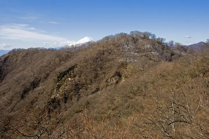
Ōmaru is a 1,386 m peak in the Tanzawa Mountains of Kanagawa Prefecture, a minor summit on the Nabewari ridge between Mt. Tōnodake and Mt. Nabewari, near the Kinhiyashi junction. It lies within Tanzawa-Ōyama Quasi-National Park. The wooded summit itself cannot be entered because of vegetation protection.
Omaru at a glance
- Weather: The most settled day in the next 7 days is Fri, November 6: clear, gusts up to 8 m/s.
- Route: The shortest is Mount To–Mount Tanzawa–Mount Nabewari Circuit from Okura: about 12 h 55 min, 23.5 km, about 1,920 m of climbing.
Omaru weather (hourly, 14 days)
Sunrise today 06:06, sunset 16:48
| Tue, 11/3 | Wed, 11/4 | Thu, 11/5 | Fri, 11/6 | Sat, 11/7 | Sun, 11/8 | Mon, 11/9 | Tue, 11/10 | Wed, 11/11 | Thu, 11/12 | Fri, 11/13 | Sat, 11/14 | Sun, 11/15 | Mon, 11/16 | Tue, 11/17 | |||||||||||||||||||||||||||||||||||||||||||||||||||||||||||||||||||||||
|---|---|---|---|---|---|---|---|---|---|---|---|---|---|---|---|---|---|---|---|---|---|---|---|---|---|---|---|---|---|---|---|---|---|---|---|---|---|---|---|---|---|---|---|---|---|---|---|---|---|---|---|---|---|---|---|---|---|---|---|---|---|---|---|---|---|---|---|---|---|---|---|---|---|---|---|---|---|---|---|---|---|---|---|---|---|
| Japan time | 15 | 17 | 19 | 21 | 23 | 1 | 3 | 5 | 7 | 9 | 11 | 13 | 15 | 18 | 21 | 0 | 3 | 6 | 9 | 12 | 15 | 18 | 21 | 0 | 3 | 6 | 9 | 12 | 15 | 18 | 21 | 0 | 3 | 6 | 9 | 12 | 15 | 18 | 21 | 0 | 3 | 6 | 9 | 12 | 15 | 18 | 21 | 0 | 3 | 6 | 9 | 15 | 21 | 3 | 9 | 15 | 21 | 3 | 9 | 15 | 21 | 3 | 9 | 15 | 21 | 3 | 9 | 15 | 21 | 3 | 9 | 15 | 21 | 3 | 9 | 15 | 21 | 3 | 9 | 15 | 21 | 3 | 9 | 15 | |
  |   | |   | | | | |   | | | | | | | | | | |   | |   |   | | | |  | | |  | | | | | | | |   |   | | | |   | | | | | | | | | | | | |   | | | | |   |  | | | | | | | | | | | | | | | | |   | | | | | | ||
| Temperature | °C | 11° | 9° | 8° | 8° | 7° | 7° | 7° | 6° | 6° | 7° | 8° | 7° | 6° | 6° | 5° | 6° | 6° | 7° | 9° | 14° | 13° | 10° | 8° | 7° | 7° | 6° | 13° | 17° | 15° | 11° | 9° | 10° | 8° | 5° | 10° | 10° | 9° | 6° | 4° | 4° | 4° | 3° | 8° | 9° | 8° | 6° | 5° | 5° | 5° | 4° | 5° | 7° | 4° | 3° | 5° | 7° | 3° | 4° | 6° | 10° | 0° | -1° | 5° | 6° | 5° | 1° | 8° | 8° | 1° | 2° | 3° | 6° | 3° | 2° | 9° | 11° | 8° | 8° | 13° | 15° | 5° | 4° | 4° | 5° |
| Precipitation | mm | 0.2 | 0.3 | 0.3 | 1.0 | 2.2 | 6 | 10 | 17 | 15 | 2.5 | 1.2 | 0.2 | 1.5 | 0.4 | 0.8 | 0.5 | 0.3 | 1.0 | 0.1 | 0.2 | 0.1 | 10 | 24 | 0.7 | 0.1 | 0.2 | ||||||||||||||||||||||||||||||||||||||||||||||||||||||||||
| New snow | cm | ||||||||||||||||||||||||||||||||||||||||||||||||||||||||||||||||||||||||||||||||||||
| Snow depth | cm | 0 | 0 | 0 | 0 | 0 | 0 | 0 | 0 | 0 | 0 | 0 | 0 | 0 | 0 | 0 | 0 | 0 | 0 | 0 | 0 | 0 | 0 | 0 | 0 | 0 | 0 | 0 | 0 | 0 | 0 | 0 | 0 | 0 | 0 | 0 | 0 | 0 | 0 | 0 | 0 | 0 | 0 | 0 | 0 | 0 | 0 | 0 | 0 | 0 | 0 | 0 | 0 | 0 | 0 | 0 | 0 | 0 | 0 | 0 | 0 | 0 | 0 | 0 | 0 | 0 | 0 | 0 | 0 | 0 | 0 | 0 | 0 | 0 | 0 | 0 | 0 | 0 | 0 | 0 | 0 | 0 | 0 | 0 | 0 |
| Wind | m/s | 2 | 1 | 1 | 1 | 1 | 1 | 1 | 1 | 1 | 2 | 2 | 2 | 2 | 2 | 2 | 2 | 3 | 3 | 3 | 2 | 2 | 0 | 1 | 0 | 1 | 1 | 0 | 2 | 2 | 1 | 1 | 0 | 2 | 1 | 1 | 2 | 2 | 1 | 1 | 0 | 0 | 0 | 1 | 2 | 2 | 1 | 1 | 1 | 1 | 1 | 1 | 2 | 2 | 2 | 2 | 2 | 0 | 1 | 3 | 3 | 1 | 0 | 1 | 2 | 1 | 2 | 1 | 2 | 1 | 0 | 1 | 2 | 0 | 0 | 2 | 3 | 1 | 0 | 2 | 2 | 2 | 1 | 1 | 2 |
| Wind gusts | m/s | 5 | 5 | 3 | 2 | 3 | 4 | 4 | 5 | 5 | 6 | 6 | 7 | 7 | 7 | 7 | 8 | 8 | 10 | 11 | 11 | 8 | 5 | 4 | 4 | 5 | 5 | 5 | 7 | 8 | 6 | 5 | 4 | 8 | 7 | 5 | 6 | 6 | 6 | 4 | 4 | 4 | 3 | 4 | 8 | 7 | 5 | 4 | 4 | 5 | 5 | 5 | 7 | 7 | 6 | 6 | 7 | 7 | 6 | 14 | 15 | 9 | 6 | 5 | 9 | 7 | 6 | 6 | 7 | 6 | 4 | 4 | 6 | 6 | 3 | 8 | 13 | 11 | 10 | 7 | 8 | 7 | 7 | 5 | 6 |
| Wind dir. | ↓ | ↓ | ↓ | ↓ | ↓ | ↓ | ↓ | ↓ | ↓ | ↓ | ↓ | ↓ | ↓ | ↓ | ↓ | ↓ | ↓ | ↓ | ↓ | ↓ | ↓ | ↓ | ↓ | ↓ | ↓ | ↓ | ↓ | ↓ | ↓ | ↓ | ↓ | ↓ | ↓ | ↓ | ↓ | ↓ | ↓ | ↓ | ↓ | ↓ | ↓ | ↓ | ↓ | ↓ | ↓ | ↓ | ↓ | ↓ | ↓ | ↓ | ↓ | ↓ | ↓ | ↓ | ↓ | ↓ | ↓ | ↓ | ↓ | ↓ | ↓ | ↓ | ↓ | ↓ | ↓ | ↓ | ↓ | ↓ | ↓ | ↓ | ↓ | ↓ | ↓ | ↓ | ↓ | ↓ | ↓ | ↓ | ↓ | ↓ | ↓ | ↓ | ↓ | ||
Omaru hiking routes
Hiking times are estimates calculated from the terrain.
Huts, campsites and lodging near Omaru
Mountain huts
- Hanatate Sanso 2026: open all year · sleeps 25
- Sonbutsu Sanso 2026: open all year · reservation required
- Kinomata Hut 2026: open all year · sleeps 14
- 鍋割山荘 2026: open all year
- 作治小屋 2026: open all year · sleeps 40
Campsites
- ユーシンロッジ
- Ookurakougen tent site
- ミロクキャンプ場
- 表丹沢野外活動センター
- 滝沢園キャンプ場
Lodging
- 国民宿舎丹沢ホーム
Omaru facts
- Elevation
- 1,386 m
- Location
- Yamakita, Kanagawa / Hadano, Kanagawa
35.449414, 139.157467 - National Park
- 丹沢大山国定公園
- Website
- www.kankou-hadano.org
- Trail Map
- kankou-hadano.org
- Wikipedia
- ja.wikipedia.org