
Mt. Myōjō
明星ヶ岳
Odawara, Kanagawa / Hakone, Kanagawa · Elevation 924 m
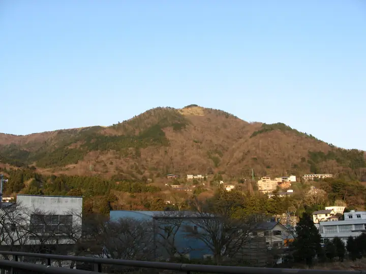
Mt. Myōjō is a 924 m peak on the boundary of Hakone Town and Odawara City in Kanagawa Prefecture, part of the older outer caldera rim of the Hakone Volcano left behind by the collapse roughly 18,000 years ago. The name is said to come from the morning star (Venus) glittering above its ridge as seen from Odawara, and it is locally also called Daimonji-yama for the giant 大 character lit on its slope every August 16 during the Hakone-Gōra Daimonji-yaki summer festival. Within Fuji-Hakone-Izu National Park, the summit is reached by maintained trails from Miyagino or Tōnosawa.
Mt. Myōjō at a glance
- Weather: The most settled day in the next 7 days is Fri, November 6: clear, gusts up to 6 m/s.
- Route: The shortest is Hakone Myojogatake from Miyagino to Miyanoshita: about 4 h 33 min, 8.1 km, about 720 m of climbing.
Mt. Myōjō weather (hourly, 14 days)
Sunrise today 06:06, sunset 16:49
| Tue, 11/3 | Wed, 11/4 | Thu, 11/5 | Fri, 11/6 | Sat, 11/7 | Sun, 11/8 | Mon, 11/9 | Tue, 11/10 | Wed, 11/11 | Thu, 11/12 | Fri, 11/13 | Sat, 11/14 | Sun, 11/15 | Mon, 11/16 | Tue, 11/17 | |||||||||||||||||||||||||||||||||||||||||||||||||||||||||||||||||||||||
|---|---|---|---|---|---|---|---|---|---|---|---|---|---|---|---|---|---|---|---|---|---|---|---|---|---|---|---|---|---|---|---|---|---|---|---|---|---|---|---|---|---|---|---|---|---|---|---|---|---|---|---|---|---|---|---|---|---|---|---|---|---|---|---|---|---|---|---|---|---|---|---|---|---|---|---|---|---|---|---|---|---|---|---|---|---|
| Japan time | 15 | 17 | 19 | 21 | 23 | 1 | 3 | 5 | 7 | 9 | 11 | 13 | 15 | 18 | 21 | 0 | 3 | 6 | 9 | 12 | 15 | 18 | 21 | 0 | 3 | 6 | 9 | 12 | 15 | 18 | 21 | 0 | 3 | 6 | 9 | 12 | 15 | 18 | 21 | 0 | 3 | 6 | 9 | 12 | 15 | 18 | 21 | 0 | 3 | 6 | 9 | 15 | 21 | 3 | 9 | 15 | 21 | 3 | 9 | 15 | 21 | 3 | 9 | 15 | 21 | 3 | 9 | 15 | 21 | 3 | 9 | 15 | 21 | 3 | 9 | 15 | 21 | 3 | 9 | 15 | 21 | 3 | 9 | 15 | |
  |   |   | | | | |   |   | | | | | | | | | | |   |   |   |   | | | | | | | |  | | | | | | | | | | | |   | | | | | | | | | | | | |   | | |  | | | | | | |   | | | | | | | | | | | | | | | | | | | ||
| Temperature | °C | 14° | 12° | 12° | 11° | 11° | 11° | 11° | 10° | 10° | 11° | 12° | 11° | 10° | 9° | 9° | 9° | 10° | 10° | 14° | 19° | 16° | 13° | 11° | 10° | 9° | 10° | 16° | 19° | 19° | 13° | 10° | 12° | 11° | 10° | 13° | 14° | 13° | 10° | 9° | 8° | 7° | 6° | 11° | 12° | 12° | 9° | 8° | 9° | 9° | 8° | 9° | 11° | 8° | 7° | 9° | 10° | 7° | 7° | 10° | 14° | 5° | 5° | 8° | 10° | 8° | 6° | 11° | 12° | 6° | 5° | 6° | 9° | 8° | 5° | 11° | 14° | 12° | 12° | 15° | 17° | 11° | 7° | 7° | 8° |
| Precipitation | mm | 0.2 | 0.3 | 0.2 | 0.9 | 3.1 | 4.8 | 10 | 12 | 8 | 0.6 | 0.2 | 1.1 | 0.3 | 0.5 | 1.8 | 0.1 | 0.2 | 0.3 | 0.1 | 0.5 | 0.3 | 10 | 23 | 2.9 | 1.1 | 0.6 | ||||||||||||||||||||||||||||||||||||||||||||||||||||||||||
| New snow | cm | ||||||||||||||||||||||||||||||||||||||||||||||||||||||||||||||||||||||||||||||||||||
| Snow depth | cm | 0 | 0 | 0 | 0 | 0 | 0 | 0 | 0 | 0 | 0 | 0 | 0 | 0 | 0 | 0 | 0 | 0 | 0 | 0 | 0 | 0 | 0 | 0 | 0 | 0 | 0 | 0 | 0 | 0 | 0 | 0 | 0 | 0 | 0 | 0 | 0 | 0 | 0 | 0 | 0 | 0 | 0 | 0 | 0 | 0 | 0 | 0 | 0 | 0 | 0 | 0 | 0 | 0 | 0 | 0 | 0 | 0 | 0 | 0 | 0 | 0 | 0 | 0 | 0 | 0 | 0 | 0 | 0 | 0 | 0 | 0 | 0 | 0 | 0 | 0 | 0 | 0 | 0 | 0 | 0 | 0 | 0 | 0 | 0 |
| Wind | m/s | 1 | 0 | 0 | 1 | 0 | 1 | 2 | 2 | 2 | 2 | 2 | 2 | 2 | 2 | 3 | 3 | 4 | 3 | 2 | 1 | 1 | 0 | 0 | 0 | 2 | 1 | 0 | 1 | 1 | 0 | 1 | 1 | 0 | 1 | 1 | 3 | 2 | 0 | 0 | 0 | 0 | 0 | 1 | 1 | 1 | 1 | 1 | 1 | 1 | 1 | 1 | 2 | 1 | 1 | 2 | 2 | 0 | 1 | 2 | 0 | 1 | 0 | 1 | 2 | 1 | 1 | 0 | 1 | 1 | 1 | 1 | 2 | 1 | 1 | 1 | 3 | 1 | 1 | 2 | 1 | 1 | 1 | 1 | 1 |
| Wind gusts | m/s | 7 | 4 | 1 | 2 | 2 | 3 | 5 | 5 | 6 | 7 | 7 | 9 | 8 | 8 | 9 | 10 | 12 | 11 | 9 | 7 | 7 | 4 | 3 | 4 | 6 | 6 | 4 | 5 | 6 | 4 | 3 | 4 | 5 | 4 | 4 | 8 | 8 | 6 | 2 | 2 | 2 | 2 | 3 | 5 | 6 | 5 | 3 | 3 | 3 | 3 | 3 | 6 | 5 | 5 | 6 | 7 | 5 | 4 | 13 | 10 | 4 | 3 | 4 | 7 | 6 | 4 | 4 | 8 | 4 | 2 | 4 | 6 | 5 | 5 | 6 | 11 | 9 | 13 | 7 | 7 | 4 | 6 | 4 | 6 |
| Wind dir. | ↓ | ↓ | ↓ | ↓ | ↓ | ↓ | ↓ | ↓ | ↓ | ↓ | ↓ | ↓ | ↓ | ↓ | ↓ | ↓ | ↓ | ↓ | ↓ | ↓ | ↓ | ↓ | ↓ | ↓ | ↓ | ↓ | ↓ | ↓ | ↓ | ↓ | ↓ | ↓ | ↓ | ↓ | ↓ | ↓ | ↓ | ↓ | ↓ | ↓ | ↓ | ↓ | ↓ | ↓ | ↓ | ↓ | ↓ | ↓ | ↓ | ↓ | ↓ | ↓ | ↓ | ↓ | ↓ | ↓ | ↓ | ↓ | ↓ | ↓ | ↓ | ↓ | ↓ | ↓ | ↓ | ↓ | ↓ | ↓ | ↓ | ↓ | ↓ | ↓ | ↓ | ↓ | ↓ | ↓ | ↓ | ↓ | ↓ | ↓ | ↓ | ↓ | ↓ | ||
Mt. Myōjō hiking routes
- Hakone Myojogatake from Miyagino to Miyanoshita 8.1 km · Ascent 716 m Miyagino Information bus stop (Bus stop), 宮城野橋 (Bus stop) (parking) → 宮ノ下 (Bus stop), Miyanoshita (Station), 宮ノ下駅 (Station), 宮ノ下温泉 (Bus stop) (parking)
- Hakone Outer Rim: Myōjōgatake, Myōjingatake and Kintokiyama 14.5 km · Ascent 1,361 m Gōra (Station), For S Line (Bus stop), 一番坂 (Bus stop) (parking) → Kintoki-tozanguchi (Bus stop), Sengoku (Bus stop) (parking)
Hiking times are estimates calculated from the terrain.
Huts, campsites and lodging near Mt. Myōjō
Mountain huts
- 明神ヶ岳見晴小屋
Lodging
- 箱根エレカーサ
- HAKONE NICA
- 源泉100%かけ流しの宿 櫻休庵
- 箱根七里の湯
- 箱根ねんねこや
Mt. Myōjō facts
- Also known as
- 大文字山 · 箱根御嶽山 · 御岳 · 久野山
- Elevation
- 924 m
- Location
- Odawara, Kanagawa / Hakone, Kanagawa
35.256120, 139.067484 - National Park
- 富士箱根伊豆国立公園
- Website
- miyaginokiga.com
- Access Information
- www.hakone.or.jp
- Wikipedia
- ja.wikipedia.org