
Mount Maku
幕山
Yugawara, Kanagawa · Elevation 626 m
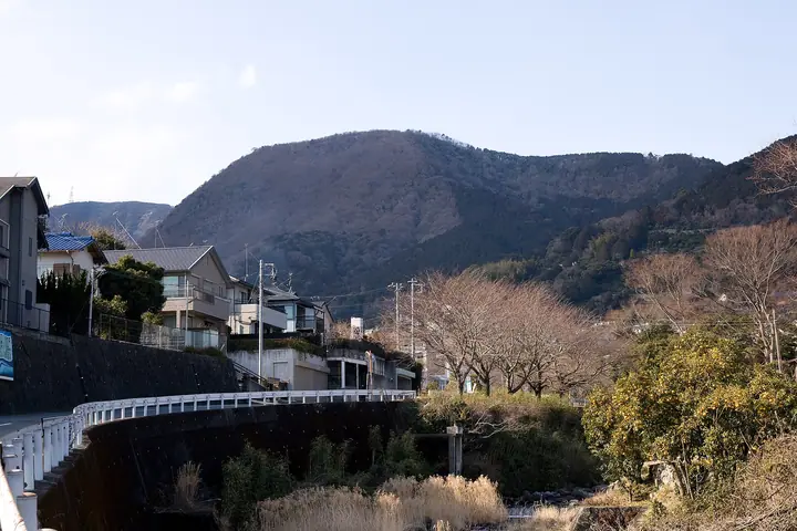
Mount Maku is a 626 m peak in Yugawara Town, Kanagawa, whose foothills cradle the Yugawara plum grove of some 4,000 red and white plum trees — celebrated each year from early February through mid-March in the Ume no Utage festival. The Maku-iwa rock face below the summit, named for its curtain-like shape, is one of the region's classic free-climbing crags, and the top opens onto views of Sagami Bay and the Manazuru Peninsula. The summit can be reached in about 70 minutes from Makuyama Park along a beginner-friendly trail, and the peak appears in Hana no Hyakumeizan, Kantō Hyakumeizan, and many other lists.
Mount Maku at a glance
- Weather: The most settled day in the next 7 days is Fri, November 6: clear, gusts up to 6 m/s.
- Route: The shortest is Mount Makuyama Loop from Makuyama Park: about 2 h 55 min, 5.4 km, about 420 m of climbing.
Mount Maku weather (hourly, 14 days)
Sunrise today 06:06, sunset 16:49
| Tue, 11/3 | Wed, 11/4 | Thu, 11/5 | Fri, 11/6 | Sat, 11/7 | Sun, 11/8 | Mon, 11/9 | Tue, 11/10 | Wed, 11/11 | Thu, 11/12 | Fri, 11/13 | Sat, 11/14 | Sun, 11/15 | Mon, 11/16 | Tue, 11/17 | |||||||||||||||||||||||||||||||||||||||||||||||||||||||||||||||||||||||
|---|---|---|---|---|---|---|---|---|---|---|---|---|---|---|---|---|---|---|---|---|---|---|---|---|---|---|---|---|---|---|---|---|---|---|---|---|---|---|---|---|---|---|---|---|---|---|---|---|---|---|---|---|---|---|---|---|---|---|---|---|---|---|---|---|---|---|---|---|---|---|---|---|---|---|---|---|---|---|---|---|---|---|---|---|---|
| Japan time | 15 | 17 | 19 | 21 | 23 | 1 | 3 | 5 | 7 | 9 | 11 | 13 | 15 | 18 | 21 | 0 | 3 | 6 | 9 | 12 | 15 | 18 | 21 | 0 | 3 | 6 | 9 | 12 | 15 | 18 | 21 | 0 | 3 | 6 | 9 | 12 | 15 | 18 | 21 | 0 | 3 | 6 | 9 | 12 | 15 | 18 | 21 | 0 | 3 | 6 | 9 | 15 | 21 | 3 | 9 | 15 | 21 | 3 | 9 | 15 | 21 | 3 | 9 | 15 | 21 | 3 | 9 | 15 | 21 | 3 | 9 | 15 | 21 | 3 | 9 | 15 | 21 | 3 | 9 | 15 | 21 | 3 | 9 | 15 | |
  |   |   | | | | |   |   | | | | | | | | | | |   |   |   |  | | | |   | |  | | | |   | | | | | | | | | | | | | | | | | | | | |   |   | | | | | |   | | | | | | | | | | | | | | | | | | | | | | | | ||
| Temperature | °C | 16° | 14° | 14° | 12° | 12° | 13° | 13° | 11° | 11° | 13° | 13° | 13° | 11° | 11° | 11° | 11° | 11° | 12° | 15° | 19° | 16° | 15° | 13° | 12° | 11° | 12° | 17° | 21° | 20° | 15° | 13° | 13° | 12° | 11° | 15° | 16° | 14° | 12° | 11° | 9° | 9° | 8° | 12° | 13° | 13° | 10° | 10° | 11° | 10° | 10° | 10° | 13° | 10° | 8° | 10° | 12° | 8° | 8° | 12° | 14° | 8° | 7° | 10° | 11° | 9° | 8° | 12° | 14° | 8° | 6° | 8° | 10° | 9° | 7° | 12° | 14° | 13° | 14° | 17° | 20° | 13° | 9° | 9° | 10° |
| Precipitation | mm | 0.4 | 0.2 | 0.4 | 1.5 | 3.9 | 3.7 | 8 | 8 | 7 | 0.2 | 0.7 | 1.2 | 0.4 | 0.1 | 0.3 | 0.1 | 0.2 | 0.6 | 7 | 21 | 4.2 | 0.5 | ||||||||||||||||||||||||||||||||||||||||||||||||||||||||||||||
| New snow | cm | ||||||||||||||||||||||||||||||||||||||||||||||||||||||||||||||||||||||||||||||||||||
| Snow depth | cm | 0 | 0 | 0 | 0 | 0 | 0 | 0 | 0 | 0 | 0 | 0 | 0 | 0 | 0 | 0 | 0 | 0 | 0 | 0 | 0 | 0 | 0 | 0 | 0 | 0 | 0 | 0 | 0 | 0 | 0 | 0 | 0 | 0 | 0 | 0 | 0 | 0 | 0 | 0 | 0 | 0 | 0 | 0 | 0 | 0 | 0 | 0 | 0 | 0 | 0 | 0 | 0 | 0 | 0 | 0 | 0 | 0 | 0 | 0 | 0 | 0 | 0 | 0 | 0 | 0 | 0 | 0 | 0 | 0 | 0 | 0 | 0 | 0 | 0 | 0 | 0 | 0 | 0 | 0 | 0 | 0 | 0 | 0 | 0 |
| Wind | m/s | 2 | 1 | 2 | 2 | 2 | 2 | 4 | 4 | 4 | 4 | 4 | 5 | 5 | 4 | 5 | 5 | 5 | 2 | 2 | 2 | 2 | 1 | 0 | 0 | 1 | 1 | 0 | 1 | 2 | 1 | 1 | 1 | 1 | 1 | 2 | 3 | 3 | 2 | 2 | 1 | 1 | 1 | 1 | 2 | 2 | 2 | 2 | 2 | 2 | 2 | 2 | 3 | 3 | 3 | 3 | 2 | 1 | 2 | 2 | 1 | 1 | 1 | 1 | 1 | 1 | 0 | 0 | 2 | 2 | 2 | 2 | 2 | 0 | 1 | 1 | 2 | 1 | 3 | 2 | 2 | 1 | 2 | 3 | 2 |
| Wind gusts | m/s | 8 | 5 | 4 | 5 | 5 | 6 | 9 | 9 | 10 | 11 | 11 | 14 | 13 | 13 | 13 | 14 | 14 | 13 | 8 | 6 | 6 | 5 | 2 | 3 | 6 | 6 | 6 | 5 | 6 | 5 | 4 | 3 | 5 | 5 | 6 | 9 | 9 | 8 | 6 | 4 | 3 | 2 | 4 | 6 | 6 | 5 | 4 | 5 | 4 | 4 | 5 | 7 | 8 | 9 | 9 | 10 | 6 | 7 | 10 | 8 | 4 | 4 | 4 | 6 | 5 | 4 | 4 | 7 | 6 | 4 | 6 | 7 | 5 | 4 | 5 | 8 | 7 | 13 | 10 | 10 | 5 | 6 | 8 | 8 |
| Wind dir. | ↓ | ↓ | ↓ | ↓ | ↓ | ↓ | ↓ | ↓ | ↓ | ↓ | ↓ | ↓ | ↓ | ↓ | ↓ | ↓ | ↓ | ↓ | ↓ | ↓ | ↓ | ↓ | ↓ | ↓ | ↓ | ↓ | ↓ | ↓ | ↓ | ↓ | ↓ | ↓ | ↓ | ↓ | ↓ | ↓ | ↓ | ↓ | ↓ | ↓ | ↓ | ↓ | ↓ | ↓ | ↓ | ↓ | ↓ | ↓ | ↓ | ↓ | ↓ | ↓ | ↓ | ↓ | ↓ | ↓ | ↓ | ↓ | ↓ | ↓ | ↓ | ↓ | ↓ | ↓ | ↓ | ↓ | ↓ | ↓ | ↓ | ↓ | ↓ | ↓ | ↓ | ↓ | ↓ | ↓ | ↓ | ↓ | ↓ | ↓ | ↓ | ↓ | ↓ | ↓ | |
Mount Maku hiking routes
- Mount Makuyama Loop from Makuyama Park 5.4 km · Ascent 420 m 幕山登山口 (parking)
- Mount Maku to Nangō Traverse from Makuyama Park to Kajiya 7.2 km · Ascent 520 m 幕山登山口 (parking) → 五郎神社
Hiking times are estimates calculated from the terrain.
Huts, campsites and lodging near Mount Maku
Lodging
- 奥湯河原温泉 加満田
- ホテル城山
- Shiroyama-kan
- 湯河原温泉 ゆがわら水の香里
- 源泉上野屋旅館
Lists that include Mount Maku
100 Famous Mountains of Flowers · Kanto 100 Famous Mountains
Mount Maku facts
- Elevation
- 626 m
- Location
- Yugawara, Kanagawa
35.173712, 139.091324 - Website
- www.yugawara.or.jp
- Trail Map
- www.yugawara.or.jp (PDF)
- Wikipedia
- ja.wikipedia.org