
Mt. Kuro
玄岳
Atami, Shizuoka · Elevation 798 m
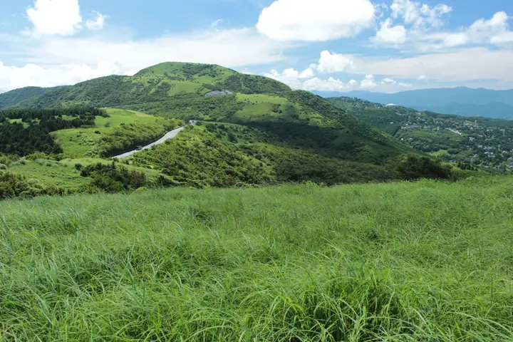
Mt. Kuro (798 m) rises just north-west of Atami City at the base of the Izu Peninsula, an eroded remnant of the Taga volcano shared by Atami, Kannami Town, and Izunokuni City. Its open, grassy summit is registered as a geosite of the Izu Peninsula Geopark and offers a sweeping panorama from Sagami Bay, Hatsushima, and Ōshima across to Hakone, Mt. Fuji, and Suruga Bay; the Izu Skyline runs along its northern slopes for further coastal views. The northern flank holds Kōri-ga-Ike pond and the ruins of the old Kurotake Drive-in, and the trail up from JR Atami Station is maintained as a walking course by the Atami Tourism Association.
Mt. Kuro at a glance
- Weather: The most settled day in the next 7 days is Fri, November 6: clear, gusts up to 6 m/s.
Mt. Kuro weather (hourly, 14 days)
Sunrise today 06:06, sunset 16:49
| Tue, 11/3 | Wed, 11/4 | Thu, 11/5 | Fri, 11/6 | Sat, 11/7 | Sun, 11/8 | Mon, 11/9 | Tue, 11/10 | Wed, 11/11 | Thu, 11/12 | Fri, 11/13 | Sat, 11/14 | Sun, 11/15 | Mon, 11/16 | Tue, 11/17 | |||||||||||||||||||||||||||||||||||||||||||||||||||||||||||||||||||||||
|---|---|---|---|---|---|---|---|---|---|---|---|---|---|---|---|---|---|---|---|---|---|---|---|---|---|---|---|---|---|---|---|---|---|---|---|---|---|---|---|---|---|---|---|---|---|---|---|---|---|---|---|---|---|---|---|---|---|---|---|---|---|---|---|---|---|---|---|---|---|---|---|---|---|---|---|---|---|---|---|---|---|---|---|---|---|
| Japan time | 15 | 17 | 19 | 21 | 23 | 1 | 3 | 5 | 7 | 9 | 11 | 13 | 15 | 18 | 21 | 0 | 3 | 6 | 9 | 12 | 15 | 18 | 21 | 0 | 3 | 6 | 9 | 12 | 15 | 18 | 21 | 0 | 3 | 6 | 9 | 12 | 15 | 18 | 21 | 0 | 3 | 6 | 9 | 12 | 15 | 18 | 21 | 0 | 3 | 6 | 9 | 15 | 21 | 3 | 9 | 15 | 21 | 3 | 9 | 15 | 21 | 3 | 9 | 15 | 21 | 3 | 9 | 15 | 21 | 3 | 9 | 15 | 21 | 3 | 9 | 15 | 21 | 3 | 9 | 15 | 21 | 3 | 9 | 15 | |
  |   | | | |   | |   |   | | | |   | | | | | |   | | |   | | | | | |   |  |  | |   | | | | | | | | | | | | | | | | | | | | | | |   | | | | | |   | | | | | | | |  | | | | | | | | | | | | | | | | ||
| Temperature | °C | 14° | 13° | 13° | 12° | 11° | 11° | 11° | 10° | 10° | 11° | 11° | 11° | 10° | 10° | 10° | 10° | 10° | 11° | 13° | 16° | 14° | 13° | 12° | 11° | 10° | 10° | 15° | 18° | 18° | 15° | 12° | 10° | 9° | 9° | 12° | 13° | 13° | 11° | 10° | 8° | 7° | 7° | 10° | 11° | 11° | 9° | 9° | 9° | 9° | 9° | 9° | 10° | 9° | 7° | 9° | 10° | 7° | 7° | 10° | 12° | 6° | 5° | 8° | 9° | 7° | 7° | 11° | 12° | 7° | 5° | 7° | 9° | 7° | 5° | 10° | 12° | 11° | 12° | 15° | 18° | 11° | 8° | 8° | 9° |
| Precipitation | mm | 0.7 | 1.1 | 2.7 | 4.3 | 5 | 7 | 3.8 | 0.3 | 1.5 | 1.8 | 0.1 | 0.6 | 0.2 | 1.4 | 7 | 23 | 6 | |||||||||||||||||||||||||||||||||||||||||||||||||||||||||||||||||||
| New snow | cm | ||||||||||||||||||||||||||||||||||||||||||||||||||||||||||||||||||||||||||||||||||||
| Snow depth | cm | 0 | 0 | 0 | 0 | 0 | 0 | 0 | 0 | 0 | 0 | 0 | 0 | 0 | 0 | 0 | 0 | 0 | 0 | 0 | 0 | 0 | 0 | 0 | 0 | 0 | 0 | 0 | 0 | 0 | 0 | 0 | 0 | 0 | 0 | 0 | 0 | 0 | 0 | 0 | 0 | 0 | 0 | 0 | 0 | 0 | 0 | 0 | 0 | 0 | 0 | 0 | 0 | 0 | 0 | 0 | 0 | 0 | 0 | 0 | 0 | 0 | 0 | 0 | 0 | 0 | 0 | 0 | 0 | 0 | 0 | 0 | 0 | 0 | 0 | 0 | 0 | 0 | 0 | 0 | 0 | 0 | 0 | 0 | 0 |
| Wind | m/s | 3 | 2 | 2 | 3 | 2 | 3 | 5 | 4 | 5 | 5 | 6 | 6 | 7 | 5 | 6 | 5 | 3 | 2 | 1 | 3 | 2 | 1 | 0 | 0 | 1 | 2 | 1 | 1 | 1 | 3 | 2 | 1 | 2 | 2 | 3 | 4 | 4 | 3 | 3 | 2 | 1 | 1 | 2 | 2 | 3 | 1 | 2 | 1 | 2 | 2 | 3 | 4 | 4 | 4 | 5 | 3 | 1 | 3 | 2 | 1 | 1 | 2 | 2 | 0 | 1 | 0 | 1 | 3 | 3 | 3 | 3 | 2 | 1 | 1 | 0 | 1 | 1 | 2 | 3 | 2 | 3 | 4 | 5 | 4 |
| Wind gusts | m/s | 8 | 7 | 6 | 6 | 6 | 6 | 9 | 9 | 10 | 11 | 12 | 14 | 14 | 14 | 13 | 13 | 11 | 7 | 5 | 7 | 7 | 5 | 3 | 3 | 5 | 6 | 6 | 5 | 6 | 7 | 8 | 6 | 5 | 5 | 7 | 8 | 10 | 10 | 9 | 7 | 5 | 4 | 7 | 7 | 7 | 6 | 5 | 6 | 4 | 5 | 7 | 9 | 10 | 10 | 10 | 11 | 7 | 8 | 13 | 7 | 6 | 5 | 5 | 5 | 4 | 4 | 3 | 7 | 8 | 7 | 8 | 8 | 4 | 4 | 4 | 5 | 5 | 10 | 8 | 10 | 9 | 9 | 10 | 10 |
| Wind dir. | ↓ | ↓ | ↓ | ↓ | ↓ | ↓ | ↓ | ↓ | ↓ | ↓ | ↓ | ↓ | ↓ | ↓ | ↓ | ↓ | ↓ | ↓ | ↓ | ↓ | ↓ | ↓ | ↓ | ↓ | ↓ | ↓ | ↓ | ↓ | ↓ | ↓ | ↓ | ↓ | ↓ | ↓ | ↓ | ↓ | ↓ | ↓ | ↓ | ↓ | ↓ | ↓ | ↓ | ↓ | ↓ | ↓ | ↓ | ↓ | ↓ | ↓ | ↓ | ↓ | ↓ | ↓ | ↓ | ↓ | ↓ | ↓ | ↓ | ↓ | ↓ | ↓ | ↓ | ↓ | ↓ | ↓ | ↓ | ↓ | ↓ | ↓ | ↓ | ↓ | ↓ | ↓ | ↓ | ↓ | ↓ | ↓ | ↓ | ↓ | ↓ | ↓ | ↓ | ↓ | |
Huts, campsites and lodging near Mt. Kuro
Lodging
- Hoshino Resorts Risonare Atami
- Atami Tensui
- Geihinkan Atami Koarashi-tei
- 石亭
- Shin Kado Ya
Lists that include Mt. Kuro
100 Mountains of Shizuoka · Elevations of 1003 Mountains of Japan
Mt. Kuro facts
- Elevation
- 798 m
- Location
- Atami, Shizuoka
35.081721, 139.028104 - Website
- www.ataminews.gr.jp
- Trail Map
- www.ataminews.gr.jp (PDF)
- Wikipedia
- ja.wikipedia.org