
Mt. Ōhira
大平山
Numazu, Shizuoka · Elevation 356 m
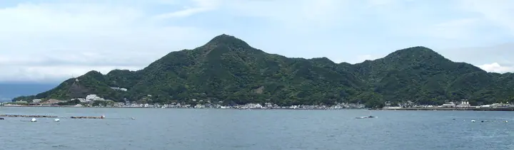
A 356 m peak on the boundary between Numazu and Izunokuni in Shizuoka, forming the southern terminus of the Numazu Alps ridge that begins at Mt. Kanuki. From Mt. Washizu it takes about 50 minutes via Tabi Pass and Tabi-guchi Pass to reach the summit, where the ridgeline opens onto a sweeping view of Suruga Bay and Mt. Fuji. Though low in elevation, the route has sharp ups-and-downs and chained scrambles, and its trails are kept up by a local volunteer hiking club.
Mt. Ōhira at a glance
- Weather: The most settled day in the next 7 days is Fri, November 6: clear, gusts up to 8 m/s.
- Route: The shortest is Numazu Alps Full Traverse from Tabi to Kurose: about 6 h 25 min, 11.0 km, about 1,050 m of climbing.
Mt. Ōhira weather (hourly, 14 days)
Sunrise today 06:07, sunset 16:49
| Tue, 11/3 | Wed, 11/4 | Thu, 11/5 | Fri, 11/6 | Sat, 11/7 | Sun, 11/8 | Mon, 11/9 | Tue, 11/10 | Wed, 11/11 | Thu, 11/12 | Fri, 11/13 | Sat, 11/14 | Sun, 11/15 | Mon, 11/16 | Tue, 11/17 | |||||||||||||||||||||||||||||||||||||||||||||||||||||||||||||||||||||||
|---|---|---|---|---|---|---|---|---|---|---|---|---|---|---|---|---|---|---|---|---|---|---|---|---|---|---|---|---|---|---|---|---|---|---|---|---|---|---|---|---|---|---|---|---|---|---|---|---|---|---|---|---|---|---|---|---|---|---|---|---|---|---|---|---|---|---|---|---|---|---|---|---|---|---|---|---|---|---|---|---|---|---|---|---|---|
| Japan time | 15 | 17 | 19 | 21 | 23 | 1 | 3 | 5 | 7 | 9 | 11 | 13 | 15 | 18 | 21 | 0 | 3 | 6 | 9 | 12 | 15 | 18 | 21 | 0 | 3 | 6 | 9 | 12 | 15 | 18 | 21 | 0 | 3 | 6 | 9 | 12 | 15 | 18 | 21 | 0 | 3 | 6 | 9 | 12 | 15 | 18 | 21 | 0 | 3 | 6 | 9 | 15 | 21 | 3 | 9 | 15 | 21 | 3 | 9 | 15 | 21 | 3 | 9 | 15 | 21 | 3 | 9 | 15 | 21 | 3 | 9 | 15 | 21 | 3 | 9 | 15 | 21 | 3 | 9 | 15 | 21 | 3 | 9 | 15 | |
  |   | |   | |   | |   |   |   | | | | | | | | | | | |   | | | | | |  | |  | | | | | | |   | | | | | | | | | | | | | | | | | | |   | | | | |   | | | | | | | | | | | | | | | | | | | | | | | | ||
| Temperature | °C | 16° | 14° | 13° | 12° | 12° | 12° | 13° | 12° | 11° | 13° | 13° | 13° | 11° | 10° | 11° | 11° | 11° | 12° | 15° | 19° | 16° | 14° | 13° | 12° | 11° | 12° | 18° | 21° | 21° | 17° | 13° | 11° | 10° | 10° | 15° | 16° | 15° | 12° | 11° | 9° | 8° | 8° | 12° | 14° | 14° | 10° | 9° | 10° | 10° | 10° | 10° | 13° | 10° | 8° | 11° | 12° | 8° | 8° | 11° | 14° | 6° | 5° | 10° | 11° | 8° | 8° | 12° | 15° | 8° | 6° | 9° | 11° | 7° | 6° | 12° | 13° | 12° | 13° | 17° | 21° | 12° | 9° | 10° | 10° |
| Precipitation | mm | 0.3 | 0.1 | 0.2 | 1.7 | 6 | 5 | 5 | 8 | 4.6 | 1.1 | 1.2 | 0.7 | 0.2 | 2.2 | 8 | 24 | 9 | |||||||||||||||||||||||||||||||||||||||||||||||||||||||||||||||||||
| New snow | cm | ||||||||||||||||||||||||||||||||||||||||||||||||||||||||||||||||||||||||||||||||||||
| Snow depth | cm | 0 | 0 | 0 | 0 | 0 | 0 | 0 | 0 | 0 | 0 | 0 | 0 | 0 | 0 | 0 | 0 | 0 | 0 | 0 | 0 | 0 | 0 | 0 | 0 | 0 | 0 | 0 | 0 | 0 | 0 | 0 | 0 | 0 | 0 | 0 | 0 | 0 | 0 | 0 | 0 | 0 | 0 | 0 | 0 | 0 | 0 | 0 | 0 | 0 | 0 | 0 | 0 | 0 | 0 | 0 | 0 | 0 | 0 | 0 | 0 | 0 | 0 | 0 | 0 | 0 | 0 | 0 | 0 | 0 | 0 | 0 | 0 | 0 | 0 | 0 | 0 | 0 | 0 | 0 | 0 | 0 | 0 | 0 | 0 |
| Wind | m/s | 4 | 2 | 2 | 2 | 2 | 2 | 3 | 3 | 3 | 4 | 5 | 5 | 5 | 4 | 5 | 3 | 1 | 2 | 2 | 2 | 2 | 2 | 1 | 1 | 0 | 1 | 2 | 2 | 3 | 4 | 1 | 1 | 2 | 1 | 3 | 3 | 4 | 3 | 2 | 2 | 2 | 2 | 3 | 3 | 2 | 1 | 2 | 2 | 1 | 2 | 3 | 4 | 3 | 3 | 4 | 3 | 2 | 3 | 1 | 2 | 1 | 2 | 2 | 1 | 1 | 1 | 0 | 2 | 2 | 3 | 3 | 2 | 1 | 0 | 1 | 2 | 1 | 2 | 3 | 2 | 2 | 3 | 4 | 4 |
| Wind gusts | m/s | 10 | 9 | 5 | 5 | 5 | 5 | 8 | 9 | 9 | 11 | 12 | 14 | 13 | 13 | 13 | 12 | 10 | 7 | 7 | 7 | 7 | 5 | 4 | 3 | 4 | 6 | 7 | 7 | 8 | 10 | 10 | 5 | 6 | 6 | 7 | 8 | 10 | 11 | 8 | 6 | 5 | 4 | 7 | 8 | 7 | 7 | 5 | 6 | 4 | 5 | 8 | 10 | 10 | 9 | 10 | 11 | 8 | 8 | 16 | 7 | 5 | 5 | 6 | 6 | 4 | 4 | 4 | 6 | 7 | 7 | 9 | 9 | 5 | 4 | 3 | 6 | 4 | 12 | 9 | 10 | 9 | 9 | 11 | 12 |
| Wind dir. | ↓ | ↓ | ↓ | ↓ | ↓ | ↓ | ↓ | ↓ | ↓ | ↓ | ↓ | ↓ | ↓ | ↓ | ↓ | ↓ | ↓ | ↓ | ↓ | ↓ | ↓ | ↓ | ↓ | ↓ | ↓ | ↓ | ↓ | ↓ | ↓ | ↓ | ↓ | ↓ | ↓ | ↓ | ↓ | ↓ | ↓ | ↓ | ↓ | ↓ | ↓ | ↓ | ↓ | ↓ | ↓ | ↓ | ↓ | ↓ | ↓ | ↓ | ↓ | ↓ | ↓ | ↓ | ↓ | ↓ | ↓ | ↓ | ↓ | ↓ | ↓ | ↓ | ↓ | ↓ | ↓ | ↓ | ↓ | ↓ | ↓ | ↓ | ↓ | ↓ | ↓ | ↓ | ↓ | ↓ | ↓ | ↓ | ↓ | ↓ | ↓ | ↓ | ↓ | ↓ | |
Mt. Ōhira hiking routes
- Numazu Alps Full Traverse from Tabi to Kurose 11.0 km · Ascent 1,054 m 多比バス停 (Bus stop), Tabi (Bus stop) → 黒瀬バス停 (Bus stop), 黒瀬 (Bus stop)
- Numazu Alps Full Traverse 15.0 km · Ascent 1,270 m 沼津駅 (Bus stop), Numazu (Station), 沼津駅北口 (Bus stop), 上本町 (Bus stop), 大手町 (Bus stop) → 原木駅 (Station), Baraki (Station) (parking)
Hiking times are estimates calculated from the terrain.
Huts, campsites and lodging near Mt. Ōhira
Lodging
- 舟平
- ニュー白坂
- ふじはら
- KKR Numazu Hamayu
- 淡路
Lists that include Mt. Ōhira
Mt. Ōhira facts
- Elevation
- 356 m
- Location
- Numazu, Shizuoka
35.059308, 138.906187 - Website
- www.city.numazu.shizuoka.jp
- Wikipedia
- ja.wikipedia.org