
Mt. Sukumo
巣雲山
Izu, Shizuoka · Elevation 581 m
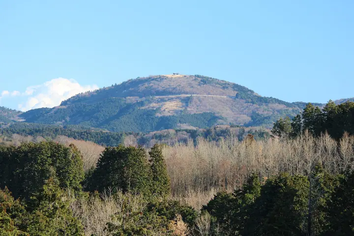
A 580.5 m scoria cone straddling Itō, Izu and Izunokuni in eastern Shizuoka, formed by the Izu East Volcanic Group some 130,000 years ago. The tree-cleared summit opens onto a full 360-degree panorama taking in Mt. Fuji, the Amagi range, the Hakone mountains and Sagami Bay, and the peak is one of the eight scenic places officially designated by Itō City. A popular 12 km loop walks up from JR Usami Station via Daimaruyama, and the mountain is widely listed among Japan's "Fuji-view" hill climbs.
Mt. Sukumo at a glance
- Weather: The most settled day in the next 7 days is Fri, November 6: clear, gusts up to 6 m/s.
Mt. Sukumo weather (hourly, 14 days)
Sunrise today 06:06, sunset 16:49
| Tue, 11/3 | Wed, 11/4 | Thu, 11/5 | Fri, 11/6 | Sat, 11/7 | Sun, 11/8 | Mon, 11/9 | Tue, 11/10 | Wed, 11/11 | Thu, 11/12 | Fri, 11/13 | Sat, 11/14 | Sun, 11/15 | Mon, 11/16 | Tue, 11/17 | |||||||||||||||||||||||||||||||||||||||||||||||||||||||||||||||||||||||
|---|---|---|---|---|---|---|---|---|---|---|---|---|---|---|---|---|---|---|---|---|---|---|---|---|---|---|---|---|---|---|---|---|---|---|---|---|---|---|---|---|---|---|---|---|---|---|---|---|---|---|---|---|---|---|---|---|---|---|---|---|---|---|---|---|---|---|---|---|---|---|---|---|---|---|---|---|---|---|---|---|---|---|---|---|---|
| Japan time | 15 | 17 | 19 | 21 | 23 | 1 | 3 | 5 | 7 | 9 | 11 | 13 | 15 | 18 | 21 | 0 | 3 | 6 | 9 | 12 | 15 | 18 | 21 | 0 | 3 | 6 | 9 | 12 | 15 | 18 | 21 | 0 | 3 | 6 | 9 | 12 | 15 | 18 | 21 | 0 | 3 | 6 | 9 | 12 | 15 | 18 | 21 | 0 | 3 | 6 | 9 | 15 | 21 | 3 | 9 | 15 | 21 | 3 | 9 | 15 | 21 | 3 | 9 | 15 | 21 | 3 | 9 | 15 | 21 | 3 | 9 | 15 | 21 | 3 | 9 | 15 | 21 | 3 | 9 | 15 | 21 | 3 | 9 | 15 | |
  |   | | | |   | |   |   | | | |   | | | | | |   | | |   | | | | | |   |  |  | |   | | | | | | | | | | | | | | | | | | | | | | |   | | | | | |   | | | | | | | |  | | | | | | | | | | | | | | | | ||
| Temperature | °C | 16° | 14° | 14° | 13° | 13° | 13° | 13° | 12° | 11° | 12° | 13° | 13° | 12° | 11° | 11° | 12° | 12° | 12° | 15° | 18° | 15° | 14° | 13° | 12° | 11° | 12° | 17° | 19° | 19° | 16° | 13° | 11° | 11° | 11° | 14° | 15° | 14° | 13° | 11° | 10° | 9° | 8° | 11° | 12° | 12° | 10° | 10° | 11° | 10° | 10° | 10° | 12° | 10° | 9° | 10° | 11° | 8° | 8° | 11° | 14° | 7° | 6° | 10° | 11° | 9° | 8° | 12° | 14° | 8° | 7° | 8° | 10° | 8° | 7° | 12° | 13° | 12° | 13° | 17° | 20° | 12° | 9° | 9° | 10° |
| Precipitation | mm | 0.7 | 1.1 | 2.7 | 4.3 | 5 | 7 | 3.8 | 0.3 | 1.5 | 1.8 | 0.1 | 0.6 | 0.2 | 1.4 | 7 | 23 | 6 | |||||||||||||||||||||||||||||||||||||||||||||||||||||||||||||||||||
| New snow | cm | ||||||||||||||||||||||||||||||||||||||||||||||||||||||||||||||||||||||||||||||||||||
| Snow depth | cm | 0 | 0 | 0 | 0 | 0 | 0 | 0 | 0 | 0 | 0 | 0 | 0 | 0 | 0 | 0 | 0 | 0 | 0 | 0 | 0 | 0 | 0 | 0 | 0 | 0 | 0 | 0 | 0 | 0 | 0 | 0 | 0 | 0 | 0 | 0 | 0 | 0 | 0 | 0 | 0 | 0 | 0 | 0 | 0 | 0 | 0 | 0 | 0 | 0 | 0 | 0 | 0 | 0 | 0 | 0 | 0 | 0 | 0 | 0 | 0 | 0 | 0 | 0 | 0 | 0 | 0 | 0 | 0 | 0 | 0 | 0 | 0 | 0 | 0 | 0 | 0 | 0 | 0 | 0 | 0 | 0 | 0 | 0 | 0 |
| Wind | m/s | 3 | 2 | 2 | 3 | 2 | 3 | 5 | 4 | 5 | 5 | 6 | 6 | 7 | 5 | 6 | 5 | 3 | 2 | 1 | 3 | 2 | 1 | 0 | 0 | 1 | 2 | 1 | 1 | 1 | 3 | 2 | 1 | 2 | 2 | 3 | 4 | 4 | 3 | 3 | 2 | 1 | 1 | 2 | 2 | 3 | 1 | 2 | 1 | 2 | 2 | 3 | 4 | 4 | 4 | 5 | 3 | 1 | 3 | 2 | 1 | 1 | 2 | 2 | 0 | 1 | 0 | 1 | 3 | 3 | 3 | 3 | 2 | 1 | 1 | 0 | 1 | 1 | 2 | 3 | 2 | 3 | 4 | 5 | 4 |
| Wind gusts | m/s | 8 | 7 | 6 | 6 | 6 | 6 | 9 | 9 | 10 | 11 | 12 | 14 | 14 | 14 | 13 | 13 | 11 | 7 | 5 | 7 | 7 | 5 | 3 | 3 | 5 | 6 | 6 | 5 | 6 | 7 | 8 | 6 | 5 | 5 | 7 | 8 | 10 | 10 | 9 | 7 | 5 | 4 | 7 | 7 | 7 | 6 | 5 | 6 | 4 | 5 | 7 | 9 | 10 | 10 | 10 | 11 | 7 | 8 | 13 | 7 | 6 | 5 | 5 | 5 | 4 | 4 | 3 | 7 | 8 | 7 | 8 | 8 | 4 | 4 | 4 | 5 | 5 | 10 | 8 | 10 | 9 | 9 | 10 | 10 |
| Wind dir. | ↓ | ↓ | ↓ | ↓ | ↓ | ↓ | ↓ | ↓ | ↓ | ↓ | ↓ | ↓ | ↓ | ↓ | ↓ | ↓ | ↓ | ↓ | ↓ | ↓ | ↓ | ↓ | ↓ | ↓ | ↓ | ↓ | ↓ | ↓ | ↓ | ↓ | ↓ | ↓ | ↓ | ↓ | ↓ | ↓ | ↓ | ↓ | ↓ | ↓ | ↓ | ↓ | ↓ | ↓ | ↓ | ↓ | ↓ | ↓ | ↓ | ↓ | ↓ | ↓ | ↓ | ↓ | ↓ | ↓ | ↓ | ↓ | ↓ | ↓ | ↓ | ↓ | ↓ | ↓ | ↓ | ↓ | ↓ | ↓ | ↓ | ↓ | ↓ | ↓ | ↓ | ↓ | ↓ | ↓ | ↓ | ↓ | ↓ | ↓ | ↓ | ↓ | ↓ | ↓ | |
Huts, campsites and lodging near Mt. Sukumo
Lodging
- 温泉民宿 鈴幸
- Tabinoya
- Himalaya Sea
Mt. Sukumo facts
- Also known as
- 牟礼山
- Elevation
- 581 m
- Location
- Izu, Shizuoka
35.005183, 139.037282 - Website
- itospa.com
- Wikipedia
- ja.wikipedia.org