
Mount Kintoki
金時山
Hakone, Kanagawa · Elevation 1,212 m
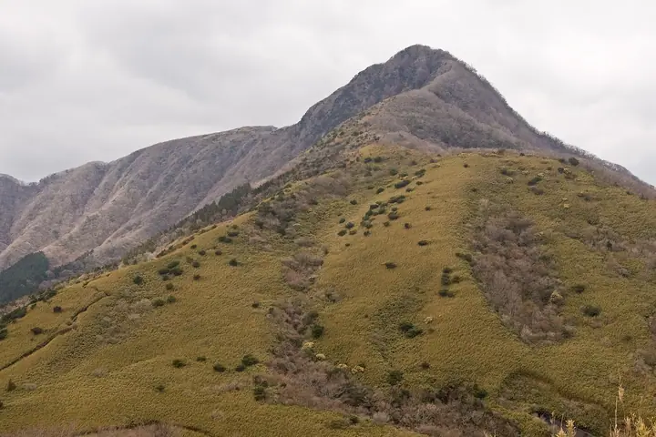
Mount Kintoki is a 1,212 m peak rising at the meeting point of Minamiashigara and Hakone in Kanagawa Prefecture and Oyama Town in Sunto District, Shizuoka Prefecture, the highest summit of the outer rim of the Hakone caldera within Fuji-Hakone-Izu National Park. Until the Edo period it was known as Inohana-yama, but in the late early-modern era it was renamed for the legendary Sakata-no-Kintoki (Kintarō of Mount Ashigara), whose folk tales had become rooted in the area. It is listed in the Nihon Sanbyaku Meizan, the Kantō Hyakumeizan, the Kantō Hyakuzan, the Nihon Hyakuteizan, and the Onsen Hyakumeizan among many others. The summit gives the most celebrated view in the Hakone region — Lake Ashi and the Sengokuhara plain below, Mount Fuji directly across, and the Tanzawa Range, the Southern Alps, and the Izu mountains stretched around the horizon. Many routes lead up: the Kintoki-jinja shrine route from Sengokuhara via the Kintoki-Yadori-ishi boulder, the ridge route from Otome Pass, the traverse from Ashigara Pass, and the Kintarō Course from Yūhi-no-Taki Falls.
Mount Kintoki at a glance
- Weather: The most settled day in the next 7 days is Fri, November 6: clear, gusts up to 6 m/s.
- Route: The shortest is Mount Marubachiyama and Mount Kintoki Out-and-Back from Kintoki Trailhead: about 1 h 57 min, 4.0 km, about 390 m of climbing.
Mount Kintoki weather (hourly, 14 days)
Sunrise today 06:07, sunset 16:49
| Tue, 11/3 | Wed, 11/4 | Thu, 11/5 | Fri, 11/6 | Sat, 11/7 | Sun, 11/8 | Mon, 11/9 | Tue, 11/10 | Wed, 11/11 | Thu, 11/12 | Fri, 11/13 | Sat, 11/14 | Sun, 11/15 | Mon, 11/16 | Tue, 11/17 | |||||||||||||||||||||||||||||||||||||||||||||||||||||||||||||||||||||||
|---|---|---|---|---|---|---|---|---|---|---|---|---|---|---|---|---|---|---|---|---|---|---|---|---|---|---|---|---|---|---|---|---|---|---|---|---|---|---|---|---|---|---|---|---|---|---|---|---|---|---|---|---|---|---|---|---|---|---|---|---|---|---|---|---|---|---|---|---|---|---|---|---|---|---|---|---|---|---|---|---|---|---|---|---|---|
| Japan time | 15 | 17 | 19 | 21 | 23 | 1 | 3 | 5 | 7 | 9 | 11 | 13 | 15 | 18 | 21 | 0 | 3 | 6 | 9 | 12 | 15 | 18 | 21 | 0 | 3 | 6 | 9 | 12 | 15 | 18 | 21 | 0 | 3 | 6 | 9 | 12 | 15 | 18 | 21 | 0 | 3 | 6 | 9 | 12 | 15 | 18 | 21 | 0 | 3 | 6 | 9 | 15 | 21 | 3 | 9 | 15 | 21 | 3 | 9 | 15 | 21 | 3 | 9 | 15 | 21 | 3 | 9 | 15 | 21 | 3 | 9 | 15 | 21 | 3 | 9 | 15 | 21 | 3 | 9 | 15 | 21 | 3 | 9 | 15 | |
  |   |   | | | | |   |   | | | | | | | | | | |   |   |   |   | | | | | | | |  | | | | | | | | | | | |   | | | | | | | | | | | | |   | | |  | | | | | | |   | | | | | | | | | | | | | | | | | | | ||
| Temperature | °C | 12° | 10° | 10° | 9° | 9° | 9° | 9° | 8° | 8° | 9° | 10° | 9° | 8° | 7° | 7° | 7° | 8° | 9° | 12° | 17° | 14° | 12° | 10° | 8° | 7° | 8° | 14° | 17° | 17° | 11° | 8° | 10° | 9° | 8° | 11° | 12° | 11° | 8° | 7° | 6° | 5° | 5° | 9° | 10° | 10° | 7° | 6° | 7° | 7° | 7° | 7° | 9° | 7° | 5° | 7° | 9° | 5° | 5° | 8° | 12° | 4° | 3° | 7° | 8° | 6° | 4° | 9° | 10° | 5° | 3° | 4° | 7° | 6° | 3° | 9° | 12° | 10° | 10° | 13° | 15° | 10° | 5° | 5° | 6° |
| Precipitation | mm | 0.2 | 0.3 | 0.2 | 0.9 | 3.1 | 4.8 | 10 | 12 | 8 | 0.6 | 0.2 | 1.1 | 0.3 | 0.5 | 1.8 | 0.1 | 0.2 | 0.3 | 0.1 | 0.5 | 0.3 | 10 | 23 | 2.9 | 1.1 | 0.6 | ||||||||||||||||||||||||||||||||||||||||||||||||||||||||||
| New snow | cm | ||||||||||||||||||||||||||||||||||||||||||||||||||||||||||||||||||||||||||||||||||||
| Snow depth | cm | 0 | 0 | 0 | 0 | 0 | 0 | 0 | 0 | 0 | 0 | 0 | 0 | 0 | 0 | 0 | 0 | 0 | 0 | 0 | 0 | 0 | 0 | 0 | 0 | 0 | 0 | 0 | 0 | 0 | 0 | 0 | 0 | 0 | 0 | 0 | 0 | 0 | 0 | 0 | 0 | 0 | 0 | 0 | 0 | 0 | 0 | 0 | 0 | 0 | 0 | 0 | 0 | 0 | 0 | 0 | 0 | 0 | 0 | 0 | 0 | 0 | 0 | 0 | 0 | 0 | 0 | 0 | 0 | 0 | 0 | 0 | 0 | 0 | 0 | 0 | 0 | 0 | 0 | 0 | 0 | 0 | 0 | 0 | 0 |
| Wind | m/s | 1 | 0 | 0 | 1 | 0 | 1 | 2 | 2 | 2 | 2 | 2 | 2 | 2 | 2 | 3 | 3 | 4 | 3 | 2 | 1 | 1 | 0 | 0 | 0 | 2 | 1 | 0 | 1 | 1 | 0 | 1 | 1 | 0 | 1 | 1 | 3 | 2 | 0 | 0 | 0 | 0 | 0 | 1 | 1 | 1 | 1 | 1 | 1 | 1 | 1 | 1 | 2 | 1 | 1 | 2 | 2 | 0 | 1 | 2 | 0 | 1 | 0 | 1 | 2 | 1 | 1 | 0 | 1 | 1 | 1 | 1 | 2 | 1 | 1 | 1 | 3 | 1 | 1 | 2 | 1 | 1 | 1 | 1 | 1 |
| Wind gusts | m/s | 7 | 4 | 1 | 2 | 2 | 3 | 5 | 5 | 6 | 7 | 7 | 9 | 8 | 8 | 9 | 10 | 12 | 11 | 9 | 7 | 7 | 4 | 3 | 4 | 6 | 6 | 4 | 5 | 6 | 4 | 3 | 4 | 5 | 4 | 4 | 8 | 8 | 6 | 2 | 2 | 2 | 2 | 3 | 5 | 6 | 5 | 3 | 3 | 3 | 3 | 3 | 6 | 5 | 5 | 6 | 7 | 5 | 4 | 13 | 10 | 4 | 3 | 4 | 7 | 6 | 4 | 4 | 8 | 4 | 2 | 4 | 6 | 5 | 5 | 6 | 11 | 9 | 13 | 7 | 7 | 4 | 6 | 4 | 6 |
| Wind dir. | ↓ | ↓ | ↓ | ↓ | ↓ | ↓ | ↓ | ↓ | ↓ | ↓ | ↓ | ↓ | ↓ | ↓ | ↓ | ↓ | ↓ | ↓ | ↓ | ↓ | ↓ | ↓ | ↓ | ↓ | ↓ | ↓ | ↓ | ↓ | ↓ | ↓ | ↓ | ↓ | ↓ | ↓ | ↓ | ↓ | ↓ | ↓ | ↓ | ↓ | ↓ | ↓ | ↓ | ↓ | ↓ | ↓ | ↓ | ↓ | ↓ | ↓ | ↓ | ↓ | ↓ | ↓ | ↓ | ↓ | ↓ | ↓ | ↓ | ↓ | ↓ | ↓ | ↓ | ↓ | ↓ | ↓ | ↓ | ↓ | ↓ | ↓ | ↓ | ↓ | ↓ | ↓ | ↓ | ↓ | ↓ | ↓ | ↓ | ↓ | ↓ | ↓ | ↓ | ||
Mount Kintoki hiking routes
- Mount Marubachiyama and Mount Kintoki Out-and-Back from Kintoki Trailhead 4.0 km · Ascent 393 m parking
- Mount Kintoki from Kintoki Miharashi Parking 2.9 km · Ascent 362 m 金時見晴パーキング
- Mount Kintoki Circuit via Kintoki Shrine and Yagurasawa Pass 5.0 km · Ascent 554 m Kintoni-jinja-iriguchi (Bus stop) (parking)
- Otome Pass to Mount Kintoki via Mount Nagao 5.5 km · Ascent 504 m 乙女峠登山口, 乙女峠 (Bus stop) (parking) → Kintoki-tozanguchi (Bus stop), Sengoku (Bus stop) (parking)
- Mount Kintoki from Otome Pass to Kintoki Trailhead 5.5 km · Ascent 533 m 乙女峠 (Bus stop) (parking) → 金時山登山口
- Mount Kintoki, Mount Nagao, and Otome Pass Loop from Kintoki Shrine Entrance 5.9 km · Ascent 615 m Kintoni-jinja-iriguchi (Bus stop) (parking)
- Mount Myojingatake and Mount Kintoki Traverse from Gora Station 8.6 km · Ascent 774 m Gōra (Station), For S Line (Bus stop), 一番坂 (Bus stop) (parking) → Kintaro Chaya
- Mount Kintoki on the Hakone Outer Rim, Return from the Gotemba Side via Otome Pass and Mount Nagao 9.8 km · Ascent 803 m 長尾口 (Bus stop), 温泉会館前 (Bus stop), 富士八景の湯 (parking)
- Mount Kintoki and Mount Myojingatake Traverse from Kintoki Shrine to Miyagino 12.1 km · Ascent 1,006 m Kintoni-jinja-iriguchi (Bus stop) (parking) → Miyagino Information bus stop (Bus stop), 宮城野橋 (Bus stop) (parking)
- Hakone Outer Rim: Myōjōgatake, Myōjingatake and Kintokiyama 14.5 km · Ascent 1,361 m Gōra (Station), For S Line (Bus stop), 一番坂 (Bus stop) (parking) → Kintoki-tozanguchi (Bus stop), Sengoku (Bus stop) (parking)
Hiking times are estimates calculated from the terrain.
Huts, campsites and lodging near Mount Kintoki
Mountain huts
Campsites
- sotosotodays CAMPGROUNDS
- 1st Campground (paid)
Lodging
- Mount View Hakone マウントビュー箱根
- Tokyu Harvest club Hakone Koshien
- Fuji-Hakone Guest House
- 実践女子学園 仙石原実習所
- EN RESORT Re Cove Hakone
Lists that include Mount Kintoki
Japan's 300 Famous Mountains · 100 Low Mountains of Japan · 100 Famous Hot Spring Mountains · Kanto 100 Famous Mountains · 100 Mountains of Shizuoka · Elevations of 1003 Mountains of Japan · 1000 Mountains of Japan
Mount Kintoki facts
- Also known as
- 公時山 · 猪鼻岳 · 猪鼻ヶ嶽
- Elevation
- 1,212 m
- Location
- Hakone, Kanagawa
35.289698, 139.004849 - National Park
- 富士箱根伊豆国立公園
- Website
- www.env.go.jp
- Wikipedia
- ja.wikipedia.org