
Mt. Ōno
大野山
Yamakita, Kanagawa · Elevation 723 m
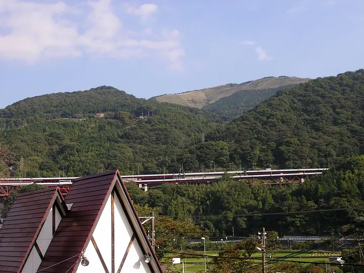
Mt. Ōno (723 m) rises in Yamakita Town, Ashigara-kami District, Kanagawa, at the south-western end of the Tanzawa Range, designated within Kanagawa Tanzawa-Ōyama Prefectural Natural Park. Its summit was once a prefecturally-run dairy ranch—closed in 2016 but its broad meadows still survive—and gives a sweeping 360-degree view that takes in Mt. Fuji, the Hakone Range, the Ashigara Plain, and the main Tanzawa ridge, earning a place on the "100 Kantō Fuji Views." The classic loop from Yaga or Yamakita stations on the JR Gotemba Line is one of the most popular family-friendly hikes in the region, and the annual "Ōno-yama-biraki" mountain-opening ceremony on 29 April draws large crowds.
Mt. Ōno at a glance
- Weather: The most settled day in the next 7 days is Fri, November 6: clear, gusts up to 7 m/s.
- Route: The shortest is Mount Ono Return from Arashi via Tsuburano: about 3 h 11 min, 5.9 km, about 370 m of climbing.
Mt. Ōno weather (hourly, 14 days)
Sunrise today 06:07, sunset 16:48
| Tue, 11/3 | Wed, 11/4 | Thu, 11/5 | Fri, 11/6 | Sat, 11/7 | Sun, 11/8 | Mon, 11/9 | Tue, 11/10 | Wed, 11/11 | Thu, 11/12 | Fri, 11/13 | Sat, 11/14 | Sun, 11/15 | Mon, 11/16 | Tue, 11/17 | |||||||||||||||||||||||||||||||||||||||||||||||||||||||||||||||||||||||
|---|---|---|---|---|---|---|---|---|---|---|---|---|---|---|---|---|---|---|---|---|---|---|---|---|---|---|---|---|---|---|---|---|---|---|---|---|---|---|---|---|---|---|---|---|---|---|---|---|---|---|---|---|---|---|---|---|---|---|---|---|---|---|---|---|---|---|---|---|---|---|---|---|---|---|---|---|---|---|---|---|---|---|---|---|---|
| Japan time | 15 | 17 | 19 | 21 | 23 | 1 | 3 | 5 | 7 | 9 | 11 | 13 | 15 | 18 | 21 | 0 | 3 | 6 | 9 | 12 | 15 | 18 | 21 | 0 | 3 | 6 | 9 | 12 | 15 | 18 | 21 | 0 | 3 | 6 | 9 | 12 | 15 | 18 | 21 | 0 | 3 | 6 | 9 | 12 | 15 | 18 | 21 | 0 | 3 | 6 | 9 | 15 | 21 | 3 | 9 | 15 | 21 | 3 | 9 | 15 | 21 | 3 | 9 | 15 | 21 | 3 | 9 | 15 | 21 | 3 | 9 | 15 | 21 | 3 | 9 | 15 | 21 | 3 | 9 | 15 | 21 | 3 | 9 | 15 | |
  |   | | | | | | |   | | | | |   | | | | |   |   | | |   | | |   |  | | |  | | |   | | |   | |   | | | | |   | | | | | | | | | | | | | | | | | |   |  | | | | | | | | | | | | | | | | | | | | | | | ||
| Temperature | °C | 13° | 11° | 11° | 10° | 10° | 10° | 9° | 9° | 8° | 10° | 10° | 10° | 9° | 8° | 8° | 8° | 8° | 9° | 12° | 17° | 14° | 12° | 10° | 8° | 7° | 8° | 15° | 18° | 17° | 12° | 9° | 10° | 10° | 8° | 12° | 12° | 11° | 9° | 7° | 7° | 6° | 5° | 9° | 11° | 10° | 8° | 7° | 7° | 7° | 7° | 8° | 9° | 7° | 6° | 8° | 9° | 6° | 5° | 9° | 12° | 2° | 2° | 7° | 8° | 7° | 3° | 10° | 11° | 5° | 4° | 5° | 8° | 5° | 3° | 10° | 13° | 10° | 10° | 14° | 16° | 9° | 6° | 5° | 7° |
| Precipitation | mm | 0.2 | 0.2 | 0.2 | 0.8 | 2.4 | 6 | 10 | 17 | 8 | 1.2 | 0.2 | 1.2 | 0.4 | 0.6 | 1.3 | 1.4 | 0.2 | 0.4 | 0.5 | 0.6 | 0.1 | 0.3 | 0.2 | 12 | 22 | 1.7 | 0.2 | 0.8 | 0.6 | |||||||||||||||||||||||||||||||||||||||||||||||||||||||
| New snow | cm | ||||||||||||||||||||||||||||||||||||||||||||||||||||||||||||||||||||||||||||||||||||
| Snow depth | cm | 0 | 0 | 0 | 0 | 0 | 0 | 0 | 0 | 0 | 0 | 0 | 0 | 0 | 0 | 0 | 0 | 0 | 0 | 0 | 0 | 0 | 0 | 0 | 0 | 0 | 0 | 0 | 0 | 0 | 0 | 0 | 0 | 0 | 0 | 0 | 0 | 0 | 0 | 0 | 0 | 0 | 0 | 0 | 0 | 0 | 0 | 0 | 0 | 0 | 0 | 0 | 0 | 0 | 0 | 0 | 0 | 0 | 0 | 0 | 0 | 0 | 0 | 0 | 0 | 0 | 0 | 0 | 0 | 0 | 0 | 0 | 0 | 0 | 0 | 0 | 0 | 0 | 0 | 0 | 0 | 0 | 0 | 0 | 0 |
| Wind | m/s | 2 | 1 | 1 | 0 | 1 | 1 | 1 | 1 | 1 | 2 | 2 | 2 | 2 | 2 | 2 | 3 | 2 | 3 | 3 | 2 | 2 | 0 | 0 | 0 | 1 | 1 | 0 | 2 | 1 | 1 | 1 | 1 | 1 | 1 | 1 | 3 | 2 | 1 | 0 | 0 | 0 | 0 | 1 | 2 | 2 | 0 | 1 | 0 | 1 | 1 | 1 | 2 | 1 | 2 | 2 | 3 | 0 | 1 | 3 | 3 | 1 | 0 | 1 | 2 | 1 | 1 | 1 | 2 | 0 | 1 | 1 | 2 | 1 | 1 | 1 | 3 | 1 | 1 | 1 | 2 | 1 | 1 | 1 | 2 |
| Wind gusts | m/s | 8 | 6 | 2 | 2 | 2 | 2 | 3 | 3 | 3 | 5 | 5 | 6 | 6 | 5 | 5 | 6 | 8 | 7 | 7 | 8 | 6 | 4 | 2 | 3 | 4 | 4 | 4 | 6 | 7 | 4 | 4 | 3 | 5 | 4 | 4 | 8 | 8 | 6 | 2 | 2 | 2 | 1 | 4 | 7 | 7 | 6 | 3 | 3 | 2 | 2 | 4 | 8 | 6 | 5 | 5 | 8 | 7 | 3 | 15 | 13 | 7 | 4 | 4 | 7 | 5 | 3 | 4 | 9 | 6 | 3 | 4 | 6 | 5 | 3 | 5 | 10 | 7 | 8 | 5 | 7 | 5 | 5 | 4 | 7 |
| Wind dir. | ↓ | ↓ | ↓ | ↓ | ↓ | ↓ | ↓ | ↓ | ↓ | ↓ | ↓ | ↓ | ↓ | ↓ | ↓ | ↓ | ↓ | ↓ | ↓ | ↓ | ↓ | ↓ | ↓ | ↓ | ↓ | ↓ | ↓ | ↓ | ↓ | ↓ | ↓ | ↓ | ↓ | ↓ | ↓ | ↓ | ↓ | ↓ | ↓ | ↓ | ↓ | ↓ | ↓ | ↓ | ↓ | ↓ | ↓ | ↓ | ↓ | ↓ | ↓ | ↓ | ↓ | ↓ | ↓ | ↓ | ↓ | ↓ | ↓ | ↓ | ↓ | ↓ | ↓ | ↓ | ↓ | ↓ | ↓ | ↓ | ↓ | ↓ | ↓ | ↓ | ↓ | ↓ | ↓ | ↓ | ↓ | ↓ | ↓ | ↓ | ↓ | ↓ | ↓ | ↓ | |
Mt. Ōno hiking routes
- Mount Ono Return from Arashi via Tsuburano 5.9 km · Ascent 370 m parking
- Ono-yama Entrance to Yaga Station via Mount Ono 10.2 km · Ascent 661 m 大野山入口 (Bus stop), 樋口橋 (Bus stop), 桶口橋 (Bus stop) (parking) → 谷峨駅 (Bus stop), Yaga (Station)
Hiking times are estimates calculated from the terrain.
Huts, campsites and lodging near Mt. Ōno
Lodging
- 料理旅館笹屋
Lists that include Mt. Ōno
Mt. Ōno facts
- Also known as
- 深沢山 · 龍集山 · 権現山 · 王ノ山 · イスマ沢ノ頭
- Elevation
- 723 m
- Location
- Yamakita, Kanagawa
35.385975, 139.048730 - Website
- www.town.yamakita.kanagawa.jp
- Trail Map
- www.town.yamakita.kanagawa.jp (PDF)
- Wikipedia
- ja.wikipedia.org