
Mt. Wasamatayama
和佐又山
Kamikitayama, Nara · Elevation 1,344 m
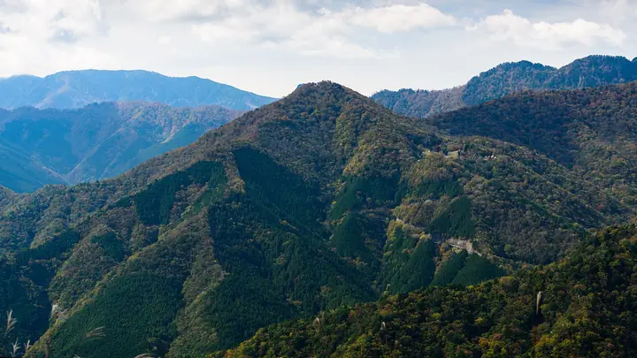
Wasamatayama is a 1,344-meter peak in the northern Omine Range, located in Kamikitayama Village, Yoshino District, Nara Prefecture, within Yoshino-Kumano National Park. From its summit one can look across the Omine main ridge toward Mount Daifugen, Mount Hakkyo, and Mount Gyojagaeri. The Wasamatayama Hut on the mountain serves as a base for climbs along the Omine Okugakemichi pilgrimage route and approaches to Mount Daifugen, with old-growth beech and fir forests, white azaleas, and autumn foliage along its trails. The peak is listed in the 'Nihon no Yama 1000' and 'Nara Hyakuyu-zan' lists.
Mt. Wasamatayama at a glance
- Weather: The most settled day in the next 7 days is Mon, November 9: clear, gusts up to 9 m/s. Fri, Nov 6, Sat, Nov 7: strong wind (gusts up to 21 m/s).
Mt. Wasamatayama weather (hourly, 14 days)
Sunrise today 06:17, sunset 17:02
| Tue, 11/3 | Wed, 11/4 | Thu, 11/5 | Fri, 11/6 | Sat, 11/7 | Sun, 11/8 | Mon, 11/9 | Tue, 11/10 | Wed, 11/11 | Thu, 11/12 | Fri, 11/13 | Sat, 11/14 | Sun, 11/15 | Mon, 11/16 | Tue, 11/17 | |||||||||||||||||||||||||||||||||||||||||||||||||||||||||||||||||||||||
|---|---|---|---|---|---|---|---|---|---|---|---|---|---|---|---|---|---|---|---|---|---|---|---|---|---|---|---|---|---|---|---|---|---|---|---|---|---|---|---|---|---|---|---|---|---|---|---|---|---|---|---|---|---|---|---|---|---|---|---|---|---|---|---|---|---|---|---|---|---|---|---|---|---|---|---|---|---|---|---|---|---|---|---|---|---|
| Japan time | 21 | 23 | 1 | 3 | 5 | 7 | 9 | 11 | 13 | 15 | 17 | 19 | 21 | 0 | 3 | 6 | 9 | 12 | 15 | 18 | 21 | 0 | 3 | 6 | 9 | 12 | 15 | 18 | 21 | 0 | 3 | 6 | 9 | 12 | 15 | 18 | 21 | 0 | 3 | 6 | 9 | 12 | 15 | 18 | 21 | 0 | 3 | 6 | 9 | 12 | 15 | 21 | 3 | 9 | 15 | 21 | 3 | 9 | 15 | 21 | 3 | 9 | 15 | 21 | 3 | 9 | 15 | 21 | 3 | 9 | 15 | 21 | 3 | 9 | 15 | 21 | 3 | 9 | 15 | 21 | 3 | 9 | 15 | 21 | |
  | |  |   | |   | |   |   | | |   | | |   | |   | | |   |   | | | | |   | | | | | | |   | | | | | | | | | | | | | | | | | | | | |  | | | | | |   |  | | | | | | | | | | | | | | | | | | | | | | |  | ||
| Temperature | °C | 5° | 5° | 4° | 4° | 4° | 5° | 10° | 12° | 11° | 10° | 9° | 9° | 9° | 9° | 10° | 9° | 13° | 16° | 17° | 12° | 11° | 12° | 11° | 9° | 9° | 12° | 11° | 8° | 6° | 4° | 3° | 1° | 5° | 6° | 5° | 2° | 1° | 1° | 1° | 0° | 4° | 8° | 8° | 3° | 4° | 6° | 7° | 6° | 8° | 10° | 8° | 3° | 2° | 7° | 9° | 4° | 1° | 2° | 4° | 0° | -1° | 5° | 7° | 2° | 0° | 3° | 5° | -1° | -1° | 8° | 11° | 2° | 4° | 10° | 11° | 11° | 11° | 10° | 9° | 4° | 0° | 3° | 7° | 1° |
| Precipitation | mm | 0.9 | 0.4 | 0.3 | 0.2 | 0.4 | 0.2 | 0.4 | 0.4 | 0.2 | 0.2 | 0.5 | 1.7 | 1.8 | 2.4 | 0.7 | 0.8 | 0.3 | 0.3 | 0.2 | 0.3 | 1.1 | 0.3 | 0.2 | 0.1 | 0.9 | 1.2 | 3.2 | 8 | 1.1 | 4.3 | 1.8 | 0.2 | ||||||||||||||||||||||||||||||||||||||||||||||||||||
| New snow | cm | – | – | – | |||||||||||||||||||||||||||||||||||||||||||||||||||||||||||||||||||||||||||||||||
| Snow depth | cm | 0 | 0 | 0 | 0 | 0 | 0 | 0 | 0 | 0 | 0 | 0 | 0 | 0 | 0 | 0 | 0 | 0 | 0 | 0 | 0 | 0 | 0 | 0 | 0 | 0 | 0 | 0 | 0 | 0 | 0 | 0 | 0 | 0 | 0 | 0 | 0 | 0 | 0 | 0 | 0 | 0 | 0 | 0 | 0 | 0 | 0 | 0 | 0 | 0 | 0 | 0 | 0 | 0 | 0 | 0 | 0 | 0 | 0 | 0 | 0 | 0 | 0 | 0 | 0 | 0 | 0 | 0 | 0 | 0 | 0 | 0 | 0 | 0 | 0 | 0 | 0 | 0 | 0 | 0 | 0 | 0 | 0 | 0 | 0 |
| Wind | m/s | 1 | 1 | 1 | 1 | 1 | 1 | 1 | 1 | 2 | 3 | 2 | 3 | 3 | 2 | 2 | 0 | 1 | 1 | 1 | 1 | 3 | 3 | 3 | 4 | 4 | 5 | 5 | 4 | 4 | 4 | 4 | 4 | 5 | 6 | 7 | 5 | 4 | 4 | 4 | 3 | 2 | 3 | 2 | 1 | 1 | 1 | 1 | 1 | 2 | 2 | 2 | 0 | 0 | 1 | 3 | 3 | 5 | 6 | 7 | 3 | 1 | 2 | 2 | 0 | 1 | 4 | 5 | 2 | 0 | 1 | 1 | 1 | 2 | 3 | 3 | 5 | 2 | 3 | 5 | 5 | 2 | 2 | 2 | 0 |
| Wind gusts | m/s | 5 | 4 | 4 | 5 | 5 | 5 | 5 | 5 | 8 | 9 | 8 | 9 | 10 | 10 | 7 | 6 | 5 | 4 | 6 | 5 | 11 | 13 | 15 | 13 | 13 | 14 | 17 | 16 | 15 | 15 | 15 | 15 | 17 | 18 | 21 | 20 | 15 | 14 | 13 | 13 | 11 | 9 | 9 | 7 | 5 | 7 | 6 | 4 | 6 | 9 | 9 | 8 | 4 | 5 | 10 | 11 | 18 | 21 | 22 | 19 | 10 | 6 | 8 | 7 | 8 | 13 | 16 | 14 | 8 | 6 | 6 | 6 | 8 | 11 | 12 | 17 | 17 | 11 | 15 | 16 | 15 | 8 | 8 | 7 |
| Wind dir. | ↓ | ↓ | ↓ | ↓ | ↓ | ↓ | ↓ | ↓ | ↓ | ↓ | ↓ | ↓ | ↓ | ↓ | ↓ | ↓ | ↓ | ↓ | ↓ | ↓ | ↓ | ↓ | ↓ | ↓ | ↓ | ↓ | ↓ | ↓ | ↓ | ↓ | ↓ | ↓ | ↓ | ↓ | ↓ | ↓ | ↓ | ↓ | ↓ | ↓ | ↓ | ↓ | ↓ | ↓ | ↓ | ↓ | ↓ | ↓ | ↓ | ↓ | ↓ | ↓ | ↓ | ↓ | ↓ | ↓ | ↓ | ↓ | ↓ | ↓ | ↓ | ↓ | ↓ | ↓ | ↓ | ↓ | ↓ | ↓ | ↓ | ↓ | ↓ | ↓ | ↓ | ↓ | ↓ | ↓ | ↓ | ↓ | ↓ | ↓ | ↓ | ↓ | ↓ | ↓ | |
Huts, campsites and lodging near Mt. Wasamatayama
Mountain huts
Lists that include Mt. Wasamatayama
Mt. Wasamatayama facts
- Elevation
- 1,344 m
- Location
- Kamikitayama, Nara
34.214947, 135.982638 - National Park
- 吉野熊野国立公園
- Website
- www.vill.kamikitayama.nara.jp
- Access Information
- yamatoji.nara-kankou.or.jp