
Mt. Tounosuyama
多峰主山
Hannō, Saitama · Elevation 271 m
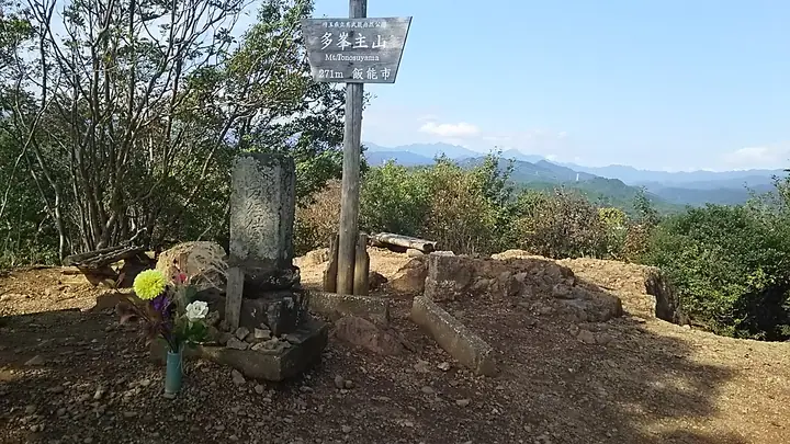
Mt. Tōnosuyama, 270.77 m, rises northwest of central Hannō on the eastern edge of the Okumusashi range, linked to neighbouring Mt. Tenranzan by a ridge trail and ranking as the highest peak inside Hannō City. The summit holds a Buddhist sutra mound and the tomb of Edo-period Fukuoka-domain lord Kuroda Naokuni (a designated city historic site), surrounded by sites of folk belief such as Amagoi Pond and Mikaeri-zaka. Short and varied — with a brief chain section — and offering panoramic views from the Kantō Plain to Tsukuba and Tokyo Skytree, it is one of the metropolitan area's most popular beginner peaks and is listed among Kantō Hyakumeizan (2019), usually combined with Tenranzan in a single loop.
Mt. Tounosuyama at a glance
- Weather: The most settled day in the next 7 days is Wed, November 4: cloudy, gusts up to 4 m/s.
- Route: The shortest is Hanno Satoyama Loop over Mount Tenran and Mount Tonosu from Hanno Central Park: about 1 h 35 min, 4.4 km, about 260 m of climbing.
Mt. Tounosuyama weather (hourly, 14 days)
Sunrise today 06:06, sunset 16:47
| Tue, 11/3 | Wed, 11/4 | Thu, 11/5 | Fri, 11/6 | Sat, 11/7 | Sun, 11/8 | Mon, 11/9 | Tue, 11/10 | Wed, 11/11 | Thu, 11/12 | Fri, 11/13 | Sat, 11/14 | Sun, 11/15 | Mon, 11/16 | Tue, 11/17 | |||||||||||||||||||||||||||||||||||||||||||||||||||||||||||||||||||||||
|---|---|---|---|---|---|---|---|---|---|---|---|---|---|---|---|---|---|---|---|---|---|---|---|---|---|---|---|---|---|---|---|---|---|---|---|---|---|---|---|---|---|---|---|---|---|---|---|---|---|---|---|---|---|---|---|---|---|---|---|---|---|---|---|---|---|---|---|---|---|---|---|---|---|---|---|---|---|---|---|---|---|---|---|---|---|
| Japan time | 15 | 17 | 19 | 21 | 23 | 1 | 3 | 5 | 7 | 9 | 11 | 13 | 15 | 18 | 21 | 0 | 3 | 6 | 9 | 12 | 15 | 18 | 21 | 0 | 3 | 6 | 9 | 12 | 15 | 18 | 21 | 0 | 3 | 6 | 9 | 12 | 15 | 18 | 21 | 0 | 3 | 6 | 9 | 12 | 15 | 18 | 21 | 0 | 3 | 6 | 9 | 15 | 21 | 3 | 9 | 15 | 21 | 3 | 9 | 15 | 21 | 3 | 9 | 15 | 21 | 3 | 9 | 15 | 21 | 3 | 9 | 15 | 21 | 3 | 9 | 15 | 21 | 3 | 9 | 15 | 21 | 3 | 9 | 15 | |
  |   |   | | | | | | | | |   | | | | | | | |   |   |   |  |   | | |  |   | |   | | | | | | | | | | | | | | | | | | | | | | | | | | | | | | |   |  | | | | | | | | | | | | | | | | |   | | | | | | ||
| Temperature | °C | 16° | 13° | 12° | 12° | 12° | 11° | 11° | 10° | 10° | 11° | 12° | 12° | 11° | 10° | 10° | 10° | 10° | 11° | 13° | 19° | 16° | 13° | 13° | 12° | 12° | 12° | 17° | 20° | 20° | 15° | 14° | 12° | 9° | 8° | 13° | 14° | 13° | 9° | 6° | 6° | 6° | 5° | 11° | 14° | 13° | 9° | 9° | 9° | 7° | 7° | 9° | 11° | 9° | 7° | 9° | 11° | 7° | 4° | 11° | 12° | 6° | 3° | 10° | 11° | 9° | 6° | 12° | 11° | 4° | 3° | 8° | 10° | 5° | 5° | 10° | 12° | 11° | 10° | 15° | 18° | 11° | 8° | 7° | 9° |
| Precipitation | mm | 0.6 | 0.8 | 0.2 | 0.4 | 0.4 | 0.2 | 0.2 | 1.1 | 6 | 13 | 12 | 3.2 | 0.8 | 2.2 | 0.8 | 0.3 | 2.4 | 15 | 0.1 | |||||||||||||||||||||||||||||||||||||||||||||||||||||||||||||||||
| New snow | cm | ||||||||||||||||||||||||||||||||||||||||||||||||||||||||||||||||||||||||||||||||||||
| Snow depth | cm | 0 | 0 | 0 | 0 | 0 | 0 | 0 | 0 | 0 | 0 | 0 | 0 | 0 | 0 | 0 | 0 | 0 | 0 | 0 | 0 | 0 | 0 | 0 | 0 | 0 | 0 | 0 | 0 | 0 | 0 | 0 | 0 | 0 | 0 | 0 | 0 | 0 | 0 | 0 | 0 | 0 | 0 | 0 | 0 | 0 | 0 | 0 | 0 | 0 | 0 | 0 | 0 | 0 | 0 | 0 | 0 | 0 | 0 | 0 | 0 | 0 | 0 | 0 | 0 | 0 | 0 | 0 | 0 | 0 | 0 | 0 | 0 | 0 | 0 | 0 | 0 | 0 | 0 | 0 | 0 | 0 | 0 | 0 | 0 |
| Wind | m/s | 2 | 1 | 1 | 1 | 1 | 1 | 1 | 1 | 0 | 1 | 0 | 1 | 1 | 1 | 2 | 2 | 4 | 4 | 4 | 3 | 1 | 1 | 0 | 0 | 0 | 0 | 1 | 1 | 2 | 1 | 3 | 3 | 1 | 2 | 2 | 3 | 3 | 2 | 2 | 2 | 3 | 3 | 2 | 1 | 2 | 1 | 0 | 0 | 2 | 0 | 1 | 2 | 1 | 2 | 1 | 2 | 1 | 1 | 7 | 5 | 3 | 1 | 1 | 1 | 1 | 0 | 2 | 7 | 2 | 1 | 2 | 2 | 0 | 0 | 1 | 1 | 1 | 0 | 0 | 7 | 5 | 2 | 1 | 2 |
| Wind gusts | m/s | 5 | 4 | 3 | 2 | 2 | 2 | 2 | 2 | 2 | 3 | 3 | 4 | 3 | 3 | 4 | 5 | 8 | 7 | 8 | 8 | 7 | 3 | 2 | 1 | 1 | 1 | 3 | 5 | 6 | 5 | 7 | 7 | 6 | 5 | 6 | 8 | 8 | 7 | 5 | 5 | 7 | 7 | 7 | 6 | 6 | 5 | 3 | 2 | 3 | 3 | 3 | 6 | 4 | 4 | 5 | 7 | 6 | 3 | 17 | 18 | 12 | 6 | 4 | 7 | 4 | 2 | 6 | 15 | 15 | 4 | 5 | 7 | 6 | 2 | 3 | 5 | 4 | 5 | 3 | 15 | 15 | 11 | 5 | 7 |
| Wind dir. | ↓ | ↓ | ↓ | ↓ | ↓ | ↓ | ↓ | ↓ | ↓ | ↓ | ↓ | ↓ | ↓ | ↓ | ↓ | ↓ | ↓ | ↓ | ↓ | ↓ | ↓ | ↓ | ↓ | ↓ | ↓ | ↓ | ↓ | ↓ | ↓ | ↓ | ↓ | ↓ | ↓ | ↓ | ↓ | ↓ | ↓ | ↓ | ↓ | ↓ | ↓ | ↓ | ↓ | ↓ | ↓ | ↓ | ↓ | ↓ | ↓ | ↓ | ↓ | ↓ | ↓ | ↓ | ↓ | ↓ | ↓ | ↓ | ↓ | ↓ | ↓ | ↓ | ↓ | ↓ | ↓ | ↓ | ↓ | ↓ | ↓ | ↓ | ↓ | ↓ | ↓ | ↓ | ↓ | ↓ | ↓ | ↓ | ↓ | ↓ | ↓ | ↓ | ↓ | ↓ | |
Mt. Tounosuyama hiking routes
- Hanno Satoyama Loop over Mount Tenran and Mount Tonosu from Hanno Central Park 4.4 km · Ascent 260 m OH!!!・天覧山下 (Bus stop), 飯能第一小学校 (Bus stop), はんのう幼稚園駐車場, 市民会館駐車場 (parking)
- Tenranzan–Tonosuyama–Agatsuma Gorge Circuit from Hanno Station 7.5 km · Ascent 260 m 飯能中央病院第4駐車場, 飯能駅南口 (Bus stop), 飯能中央病院第1駐車場, 飯能中央病院第3駐車場 (parking)
- Tenranzan, Tounosu-yama and Doremifa Bridge Loop from Hanno Station 8.1 km · Ascent 257 m 飯能駅北口 (Bus stop), Hanno (Station), 飯能駅南口 (Bus stop), 車庫前 (Bus stop) (parking)
- East Hanno Alps, from Mount Tengaku to Mount Tenran along a Ridge of Endless Small Ups and Downs 12.1 km · Ascent 850 m Higashi-Agano (Station), 東吾野駅 (Station), 西武スマイルパーク 東吾野駅前 → 飯能駅北口 (Bus stop), Hanno (Station), 飯能駅南口 (Bus stop), 車庫前 (Bus stop) (parking)
- Hanno Alps Half Traverse from Agano Station over Otakayama, Tenkakusan and Tonosuyama to Hanno Station 14.7 km · Ascent 1,152 m 吾野駅 (Station), Agano (Station) → 飯能駅北口 (Bus stop), Hanno (Station), 飯能駅南口 (Bus stop), 車庫前 (Bus stop) (parking)
Hiking times are estimates calculated from the terrain.
Huts, campsites and lodging near Mt. Tounosuyama
Lodging
- 飯能信用金庫研修所
- 奥むさし旅館
- ビジネスホテルおがわ
- HANNODAI-ICHI HOTEL
- Hotel Heritage HANNO sta.
Mt. Tounosuyama facts
- Also known as
- 多峯主山
- Elevation
- 271 m
- Location
- Hannō, Saitama
35.868121, 139.297940 - Website
- hanno-tourism.jp
- Trail Map
- hanno-tourism.jp (PDF)
- Wikipedia
- ja.wikipedia.org