
Mt. Tengakuzan
天覚山
Hannō, Saitama · Elevation 446 m
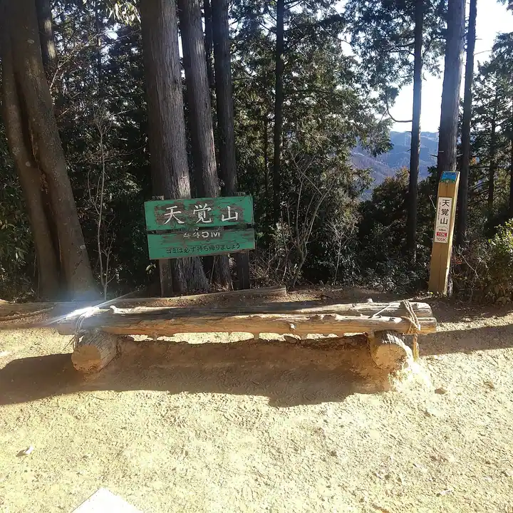
Mt. Tengakuzan is a 445.5-meter peak in Hanno City, Saitama Prefecture, on the eastern edge of the Okumusashi mountains. It stands on the "Hanno Alps" ridge that links Mt. Tenranzan and Mt. Tonosuyama with Mt. Otakayama and Mt. Izugatake. The mountain's older name, Ryohozan, comes from the Ryoho Shrine that once stood just below the summit. Its slopes are clothed in the planted cedar and cypress known as "Nishikawa timber," keeping the mountain green through winter. The south-facing summit looks out over the Okutama peaks, and station-to-station hikes on the Seibu Ikebukuro Line make it a popular day-hiking destination.
Mt. Tengakuzan at a glance
- Weather: The most settled day in the next 7 days is Wed, November 4: cloudy, gusts up to 4 m/s.
- Route: The shortest is Hanno Alps from Tenkakusan to Otakayama, Higashi-Agano to Agano Station: about 4 h 4 min, 6.2 km, about 670 m of climbing.
Mt. Tengakuzan weather (hourly, 14 days)
Sunrise today 06:06, sunset 16:47
| Tue, 11/3 | Wed, 11/4 | Thu, 11/5 | Fri, 11/6 | Sat, 11/7 | Sun, 11/8 | Mon, 11/9 | Tue, 11/10 | Wed, 11/11 | Thu, 11/12 | Fri, 11/13 | Sat, 11/14 | Sun, 11/15 | Mon, 11/16 | Tue, 11/17 | |||||||||||||||||||||||||||||||||||||||||||||||||||||||||||||||||||||||
|---|---|---|---|---|---|---|---|---|---|---|---|---|---|---|---|---|---|---|---|---|---|---|---|---|---|---|---|---|---|---|---|---|---|---|---|---|---|---|---|---|---|---|---|---|---|---|---|---|---|---|---|---|---|---|---|---|---|---|---|---|---|---|---|---|---|---|---|---|---|---|---|---|---|---|---|---|---|---|---|---|---|---|---|---|---|
| Japan time | 15 | 17 | 19 | 21 | 23 | 1 | 3 | 5 | 7 | 9 | 11 | 13 | 15 | 18 | 21 | 0 | 3 | 6 | 9 | 12 | 15 | 18 | 21 | 0 | 3 | 6 | 9 | 12 | 15 | 18 | 21 | 0 | 3 | 6 | 9 | 12 | 15 | 18 | 21 | 0 | 3 | 6 | 9 | 12 | 15 | 18 | 21 | 0 | 3 | 6 | 9 | 15 | 21 | 3 | 9 | 15 | 21 | 3 | 9 | 15 | 21 | 3 | 9 | 15 | 21 | 3 | 9 | 15 | 21 | 3 | 9 | 15 | 21 | 3 | 9 | 15 | 21 | 3 | 9 | 15 | 21 | 3 | 9 | 15 | |
  |   |   | | | | | | | | |   | | | | | | | |   |   |   |  |   | | |  |   | |   | | | | | | | | | | | | | | | | | | | | | | | | | | | | | | |   |  | | | | | | | | | | | | | | | | |   | | | | | | ||
| Temperature | °C | 14° | 12° | 11° | 11° | 11° | 10° | 9° | 9° | 9° | 10° | 11° | 11° | 10° | 9° | 9° | 9° | 9° | 10° | 12° | 18° | 15° | 12° | 12° | 11° | 11° | 11° | 16° | 19° | 19° | 14° | 13° | 11° | 8° | 7° | 12° | 13° | 12° | 8° | 5° | 5° | 5° | 4° | 10° | 13° | 12° | 8° | 8° | 7° | 6° | 6° | 8° | 10° | 8° | 6° | 8° | 9° | 6° | 3° | 10° | 11° | 5° | 2° | 8° | 10° | 8° | 5° | 11° | 10° | 2° | 2° | 6° | 9° | 4° | 4° | 8° | 11° | 9° | 9° | 14° | 17° | 9° | 7° | 6° | 8° |
| Precipitation | mm | 0.6 | 0.8 | 0.2 | 0.4 | 0.4 | 0.2 | 0.2 | 1.1 | 6 | 13 | 12 | 3.2 | 0.8 | 2.2 | 0.8 | 0.3 | 2.4 | 15 | 0.1 | |||||||||||||||||||||||||||||||||||||||||||||||||||||||||||||||||
| New snow | cm | ||||||||||||||||||||||||||||||||||||||||||||||||||||||||||||||||||||||||||||||||||||
| Snow depth | cm | 0 | 0 | 0 | 0 | 0 | 0 | 0 | 0 | 0 | 0 | 0 | 0 | 0 | 0 | 0 | 0 | 0 | 0 | 0 | 0 | 0 | 0 | 0 | 0 | 0 | 0 | 0 | 0 | 0 | 0 | 0 | 0 | 0 | 0 | 0 | 0 | 0 | 0 | 0 | 0 | 0 | 0 | 0 | 0 | 0 | 0 | 0 | 0 | 0 | 0 | 0 | 0 | 0 | 0 | 0 | 0 | 0 | 0 | 0 | 0 | 0 | 0 | 0 | 0 | 0 | 0 | 0 | 0 | 0 | 0 | 0 | 0 | 0 | 0 | 0 | 0 | 0 | 0 | 0 | 0 | 0 | 0 | 0 | 0 |
| Wind | m/s | 2 | 1 | 1 | 1 | 1 | 1 | 1 | 1 | 0 | 1 | 0 | 1 | 1 | 1 | 2 | 2 | 4 | 4 | 4 | 3 | 1 | 1 | 0 | 0 | 0 | 0 | 1 | 1 | 2 | 1 | 3 | 3 | 1 | 2 | 2 | 3 | 3 | 2 | 2 | 2 | 3 | 3 | 2 | 1 | 2 | 1 | 0 | 0 | 2 | 0 | 1 | 2 | 1 | 2 | 1 | 2 | 1 | 1 | 7 | 5 | 3 | 1 | 1 | 1 | 1 | 0 | 2 | 7 | 2 | 1 | 2 | 2 | 0 | 0 | 1 | 1 | 1 | 0 | 0 | 7 | 5 | 2 | 1 | 2 |
| Wind gusts | m/s | 5 | 4 | 3 | 2 | 2 | 2 | 2 | 2 | 2 | 3 | 3 | 4 | 3 | 3 | 4 | 5 | 8 | 7 | 8 | 8 | 7 | 3 | 2 | 1 | 1 | 1 | 3 | 5 | 6 | 5 | 7 | 7 | 6 | 5 | 6 | 8 | 8 | 7 | 5 | 5 | 7 | 7 | 7 | 6 | 6 | 5 | 3 | 2 | 3 | 3 | 3 | 6 | 4 | 4 | 5 | 7 | 6 | 3 | 17 | 18 | 12 | 6 | 4 | 7 | 4 | 2 | 6 | 15 | 15 | 4 | 5 | 7 | 6 | 2 | 3 | 5 | 4 | 5 | 3 | 15 | 15 | 11 | 5 | 7 |
| Wind dir. | ↓ | ↓ | ↓ | ↓ | ↓ | ↓ | ↓ | ↓ | ↓ | ↓ | ↓ | ↓ | ↓ | ↓ | ↓ | ↓ | ↓ | ↓ | ↓ | ↓ | ↓ | ↓ | ↓ | ↓ | ↓ | ↓ | ↓ | ↓ | ↓ | ↓ | ↓ | ↓ | ↓ | ↓ | ↓ | ↓ | ↓ | ↓ | ↓ | ↓ | ↓ | ↓ | ↓ | ↓ | ↓ | ↓ | ↓ | ↓ | ↓ | ↓ | ↓ | ↓ | ↓ | ↓ | ↓ | ↓ | ↓ | ↓ | ↓ | ↓ | ↓ | ↓ | ↓ | ↓ | ↓ | ↓ | ↓ | ↓ | ↓ | ↓ | ↓ | ↓ | ↓ | ↓ | ↓ | ↓ | ↓ | ↓ | ↓ | ↓ | ↓ | ↓ | ↓ | ↓ | |
Mt. Tengakuzan hiking routes
- Hanno Alps from Tenkakusan to Otakayama, Higashi-Agano to Agano Station 6.2 km · Ascent 669 m Higashi-Agano (Station), 東吾野駅 (Station), 西武スマイルパーク 東吾野駅前 → 吾野駅 (Station), Agano (Station)
- East Hanno Alps, from Mount Tengaku to Mount Tenran along a Ridge of Endless Small Ups and Downs 12.1 km · Ascent 850 m Higashi-Agano (Station), 東吾野駅 (Station), 西武スマイルパーク 東吾野駅前 → 飯能駅北口 (Bus stop), Hanno (Station), 飯能駅南口 (Bus stop), 車庫前 (Bus stop) (parking)
- Hanno Alps Half Traverse from Agano Station over Otakayama, Tenkakusan and Tonosuyama to Hanno Station 14.7 km · Ascent 1,152 m 吾野駅 (Station), Agano (Station) → 飯能駅北口 (Bus stop), Hanno (Station), 飯能駅南口 (Bus stop), 車庫前 (Bus stop) (parking)
Hiking times are estimates calculated from the terrain.
Mt. Tengakuzan facts
- Also known as
- 両峯山 · てんかくさん
- Elevation
- 446 m
- Location
- Hannō, Saitama
35.886760, 139.249113 - Wikipedia
- ja.wikipedia.org