
Mt. Mekoshiki
女甑山
Yurihonjo, Akita / Mamurogawa, Yamagata · Elevation 979 m
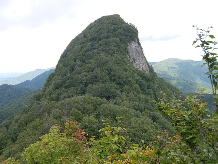
Mt. Mekoshiki (979 m) is the western summit of the twin Koshiki peaks straddling Mamurogawa Town in Yamagata Prefecture and Yuzawa City in Akita Prefecture, paired with Mt. Okoshiki to the east. It is included in the Tōhoku 100 Famous Mountains, and the surrounding old-growth beech forest is among the finest in northeastern Japan, with a giant Japanese katsura tree listed in the Ministry of the Environment's "100 Forest Giants of Japan." A short Beech Trekking Course of about thirty minutes one way reaches a viewpoint near the summit and the great katsura. Bears are active in the area and hikers are advised to carry deterrents.
Mt. Mekoshiki at a glance
- Weather: The most settled day in the next 7 days is Wed, November 4: cloudy, gusts up to 7 m/s. Fri, Nov 6, Sat, Nov 7, Sun, Nov 8: strong wind (gusts up to 17 m/s).
Mt. Mekoshiki weather (hourly, 14 days)
Sunrise today 06:07, sunset 16:37
| Tue, 11/3 | Wed, 11/4 | Thu, 11/5 | Fri, 11/6 | Sat, 11/7 | Sun, 11/8 | Mon, 11/9 | Tue, 11/10 | Wed, 11/11 | Thu, 11/12 | Fri, 11/13 | Sat, 11/14 | Sun, 11/15 | Mon, 11/16 | Tue, 11/17 | |||||||||||||||||||||||||||||||||||||||||||||||||||||||||||||||||||||||
|---|---|---|---|---|---|---|---|---|---|---|---|---|---|---|---|---|---|---|---|---|---|---|---|---|---|---|---|---|---|---|---|---|---|---|---|---|---|---|---|---|---|---|---|---|---|---|---|---|---|---|---|---|---|---|---|---|---|---|---|---|---|---|---|---|---|---|---|---|---|---|---|---|---|---|---|---|---|---|---|---|---|---|---|---|---|
| Japan time | 15 | 17 | 19 | 21 | 23 | 1 | 3 | 5 | 7 | 9 | 11 | 13 | 15 | 18 | 21 | 0 | 3 | 6 | 9 | 12 | 15 | 18 | 21 | 0 | 3 | 6 | 9 | 12 | 15 | 18 | 21 | 0 | 3 | 6 | 9 | 12 | 15 | 18 | 21 | 0 | 3 | 6 | 9 | 12 | 15 | 18 | 21 | 0 | 3 | 6 | 9 | 15 | 21 | 3 | 9 | 15 | 21 | 3 | 9 | 15 | 21 | 3 | 9 | 15 | 21 | 3 | 9 | 15 | 21 | 3 | 9 | 15 | 21 | 3 | 9 | 15 | 21 | 3 | 9 | 15 | 21 | 3 | 9 | 15 | |
  |  | | |   | | |   |   | |   |   | | | | |   |   | | | |   | |   | | | |   | | | | | |   |   |   | | | | | | | | |   | | | | | | | | | |  | | | | | |   | | | | | | | | | | | |  | | | | | | | | | | | | ||
| Temperature | °C | 7° | 3° | 2° | 1° | 0° | 1° | 1° | 1° | 3° | 7° | 10° | 11° | 10° | 4° | 4° | 5° | 7° | 6° | 8° | 9° | 9° | 7° | 8° | 8° | 8° | 8° | 10° | 12° | 9° | 6° | 4° | 2° | 1° | 0° | 1° | 2° | 1° | -1° | -1° | 0° | 0° | 0° | 2° | 4° | 3° | 0° | -1° | -3° | -1° | -2° | 3° | 2° | -3° | -3° | 2° | 5° | 2° | 1° | 1° | 3° | -1° | 1° | 4° | 5° | 0° | 2° | 1° | 2° | 0° | -1° | 4° | 6° | -2° | -3° | 6° | 10° | 4° | 4° | 6° | 4° | -1° | 0° | 2° | 4° |
| Precipitation | mm | 0.2 | 0.3 | 0.2 | 1.6 | 3.7 | 2.6 | 0.6 | 0.1 | 1.6 | 3.0 | 1.6 | 2.4 | 2.2 | 1.1 | 0.6 | 1.4 | 3.5 | 2.1 | 2.7 | 1.7 | 1.9 | 1.8 | 1.7 | 1.3 | 0.9 | 1.5 | 1.0 | 0.4 | 0.2 | 0.1 | 1.8 | 8 | 2.0 | 0.5 | 0.1 | 0.3 | 0.1 | 10 | 1.2 | 0.2 | 2.4 | 4.5 | 3.2 | 4.7 | 3.3 | 0.2 | ||||||||||||||||||||||||||||||||||||||
| New snow | cm | <.1 | 0.2 | 0.5 | 0.4 | 0.3 | 0.1 | <.1 | 0.1 | <.1 | <.1 | <.1 | |||||||||||||||||||||||||||||||||||||||||||||||||||||||||||||||||||||||||
| Snow depth | cm | 0 | 0 | 0 | 0 | 0 | 0 | 0 | 0 | 0 | 0 | 0 | 0 | 0 | 0 | 0 | 0 | 0 | 0 | 0 | 0 | 0 | 0 | 0 | 0 | 0 | 0 | 0 | 0 | 0 | 0 | 0 | 0 | 0 | 0 | <1 | <1 | <1 | <1 | <1 | <1 | <1 | <1 | <1 | <1 | 0 | 0 | 0 | 0 | 0 | 0 | 0 | 0 | 0 | 0 | 0 | 0 | 0 | 0 | 0 | 0 | 0 | 0 | 0 | 0 | 0 | 0 | 0 | 0 | 0 | 0 | 0 | 0 | 0 | 0 | 0 | 0 | 0 | 0 | 0 | 0 | 0 | 0 | 0 | 0 |
| Wind | m/s | 3 | 1 | 1 | 1 | 1 | 1 | 2 | 2 | 3 | 3 | 2 | 2 | 2 | 1 | 1 | 3 | 4 | 3 | 2 | 1 | 2 | 1 | 2 | 3 | 3 | 2 | 3 | 6 | 5 | 3 | 4 | 2 | 2 | 2 | 3 | 4 | 4 | 3 | 3 | 2 | 2 | 2 | 6 | 7 | 5 | 1 | 1 | 1 | 2 | 1 | 3 | 3 | 0 | 0 | 1 | 3 | 4 | 3 | 2 | 4 | 1 | 1 | 0 | 3 | 3 | 1 | 4 | 5 | 2 | 0 | 0 | 2 | 0 | 1 | 2 | 1 | 3 | 1 | 0 | 5 | 3 | 2 | 2 | 2 |
| Wind gusts | m/s | 10 | 8 | 3 | 3 | 3 | 4 | 6 | 6 | 6 | 7 | 7 | 7 | 6 | 6 | 4 | 7 | 9 | 9 | 9 | 5 | 4 | 4 | 6 | 7 | 7 | 6 | 9 | 14 | 16 | 11 | 10 | 10 | 7 | 9 | 11 | 15 | 16 | 14 | 11 | 8 | 8 | 7 | 13 | 16 | 17 | 13 | 5 | 4 | 5 | 4 | 7 | 8 | 6 | 2 | 5 | 8 | 13 | 14 | 7 | 12 | 11 | 4 | 3 | 8 | 7 | 7 | 10 | 13 | 12 | 6 | 3 | 6 | 5 | 3 | 5 | 9 | 8 | 8 | 3 | 13 | 13 | 9 | 5 | 6 |
| Wind dir. | ↓ | ↓ | ↓ | ↓ | ↓ | ↓ | ↓ | ↓ | ↓ | ↓ | ↓ | ↓ | ↓ | ↓ | ↓ | ↓ | ↓ | ↓ | ↓ | ↓ | ↓ | ↓ | ↓ | ↓ | ↓ | ↓ | ↓ | ↓ | ↓ | ↓ | ↓ | ↓ | ↓ | ↓ | ↓ | ↓ | ↓ | ↓ | ↓ | ↓ | ↓ | ↓ | ↓ | ↓ | ↓ | ↓ | ↓ | ↓ | ↓ | ↓ | ↓ | ↓ | ↓ | ↓ | ↓ | ↓ | ↓ | ↓ | ↓ | ↓ | ↓ | ↓ | ↓ | ↓ | ↓ | ↓ | ↓ | ↓ | ↓ | ↓ | ↓ | ↓ | ↓ | ↓ | ↓ | ↓ | ↓ | ↓ | ↓ | ↓ | ↓ | ↓ | ↓ | ↓ | |
Lists that include Mt. Mekoshiki
Mt. Mekoshiki facts
- Elevation
- 979 m
- Location
- Yurihonjo, Akita / Mamurogawa, Yamagata
39.020026, 140.314980 - Website
- yamagatayama.com
- Trail Map
- yamagatayama.com
- Access Information
- yamagatayama.com
- Wikipedia
- ja.wikipedia.org