
Mount Okoshiki
男甑山
Mamurogawa, Yamagata · Elevation 981 m
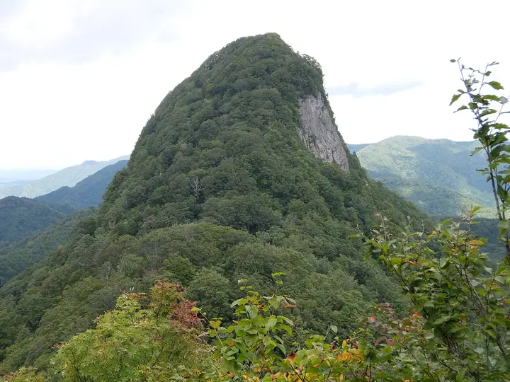
Mount Okoshiki (981.4 m) is a rocky peak straddling Mamurogawa Town in Yamagata and Yuzawa City in Akita, paired with the adjacent Mekoshiki-yama as the twin summits collectively called Mount Koshiki. Located at the southern edge of Kamuro Prefectural Natural Park, it is known for sheer slab walls on its southeast face and its iconic Eboshi Rock. The summit looks out to Mount Chōkai, Gassan, and the Kamuro Range; a direct ascent from the Kamuro-yama Forest Road takes about two hours, while a 4.5-hour loop follows the historic Yajima Highway from the Edo period. The peak is listed in the Yamagata 100.
Mount Okoshiki at a glance
- Weather: The most settled day in the next 7 days is Wed, November 4: cloudy, gusts up to 8 m/s. Fri, Nov 6, Sat, Nov 7, Sun, Nov 8: strong wind (gusts up to 19 m/s).
Mount Okoshiki weather (hourly, 14 days)
Sunrise today 06:07, sunset 16:37
| Tue, 11/3 | Wed, 11/4 | Thu, 11/5 | Fri, 11/6 | Sat, 11/7 | Sun, 11/8 | Mon, 11/9 | Tue, 11/10 | Wed, 11/11 | Thu, 11/12 | Fri, 11/13 | Sat, 11/14 | Sun, 11/15 | Mon, 11/16 | Tue, 11/17 | |||||||||||||||||||||||||||||||||||||||||||||||||||||||||||||||||||||||
|---|---|---|---|---|---|---|---|---|---|---|---|---|---|---|---|---|---|---|---|---|---|---|---|---|---|---|---|---|---|---|---|---|---|---|---|---|---|---|---|---|---|---|---|---|---|---|---|---|---|---|---|---|---|---|---|---|---|---|---|---|---|---|---|---|---|---|---|---|---|---|---|---|---|---|---|---|---|---|---|---|---|---|---|---|---|
| Japan time | 21 | 23 | 1 | 3 | 5 | 7 | 9 | 11 | 13 | 15 | 17 | 19 | 21 | 0 | 3 | 6 | 9 | 12 | 15 | 18 | 21 | 0 | 3 | 6 | 9 | 12 | 15 | 18 | 21 | 0 | 3 | 6 | 9 | 12 | 15 | 18 | 21 | 0 | 3 | 6 | 9 | 12 | 15 | 18 | 21 | 0 | 3 | 6 | 9 | 12 | 15 | 21 | 3 | 9 | 15 | 21 | 3 | 9 | 15 | 21 | 3 | 9 | 15 | 21 | 3 | 9 | 15 | 21 | 3 | 9 | 15 | 21 | 3 | 9 | 15 | 21 | 3 | 9 | 15 | 21 | 3 | 9 | 15 | 21 | |
 | |   | |   |   |   |   |   | | | | | | |   |   | |   |   | |   | | | | | | | | | |   |   |   | | |   |   | | | | | | |   | | | | | | | | |  | | | | | |   | | | | | | | | | | | |  | | | | | | | | | | | | | ||
| Temperature | °C | 1° | 0° | 0° | 1° | 2° | 3° | 8° | 9° | 10° | 9° | 5° | 3° | 4° | 5° | 6° | 7° | 8° | 9° | 10° | 8° | 8° | 7° | 8° | 7° | 10° | 12° | 9° | 6° | 4° | 2° | 1° | 0° | 1° | 3° | 0° | -1° | -1° | -1° | -1° | -2° | 3° | 4° | 3° | 0° | 0° | 0° | -1° | -1° | 0° | 2° | 1° | -3° | -3° | 2° | 5° | 2° | 1° | 1° | 3° | -1° | 1° | 4° | 5° | 0° | 2° | 1° | 2° | 0° | -1° | 3° | 6° | -2° | -3° | 6° | 10° | 4° | 4° | 6° | 4° | -1° | 0° | 2° | 4° | 1° |
| Precipitation | mm | 0.1 | 0.2 | 0.3 | 0.5 | 3.7 | 5 | 0.2 | 0.1 | 1.2 | 0.2 | 0.7 | 0.7 | 1.3 | 0.7 | 2.4 | 4.0 | 1.7 | 1.1 | 1.4 | 1.4 | 1.3 | 1.3 | 0.7 | 0.6 | 0.5 | 0.5 | 0.8 | 1.4 | 0.8 | 0.7 | 1.1 | 1.8 | 8 | 2.0 | 0.5 | 0.1 | 0.3 | 0.1 | 10 | 1.2 | 0.2 | 2.4 | 4.5 | 3.2 | 4.7 | 3.3 | 0.2 | |||||||||||||||||||||||||||||||||||||
| New snow | cm | <.1 | <.1 | 0.2 | <.1 | 0.3 | <.1 | 0.1 | 0.1 | 0.1 | <.1 | 0.1 | 0.3 | 0.1 | <.1 | <.1 | |||||||||||||||||||||||||||||||||||||||||||||||||||||||||||||||||||||
| Snow depth | cm | 0 | 0 | 0 | 0 | 0 | 0 | 0 | 0 | 0 | 0 | 0 | 0 | 0 | 0 | 0 | 0 | 0 | 0 | 0 | 0 | 0 | 0 | 0 | 0 | 0 | 0 | 0 | 0 | 0 | 0 | 0 | 0 | <1 | <1 | <1 | <1 | <1 | <1 | <1 | <1 | <1 | <1 | 0 | 0 | 0 | 0 | 0 | 0 | 0 | 0 | 0 | 0 | 0 | 0 | 0 | 0 | 0 | 0 | 0 | 0 | 0 | 0 | 0 | 0 | 0 | 0 | 0 | 0 | 0 | 0 | 0 | 0 | 0 | 0 | 0 | 0 | 0 | 0 | 0 | 0 | 0 | 0 | 0 | 0 |
| Wind | m/s | 1 | 1 | 2 | 2 | 2 | 2 | 2 | 2 | 2 | 2 | 1 | 1 | 1 | 2 | 4 | 3 | 1 | 1 | 1 | 1 | 2 | 1 | 1 | 2 | 2 | 6 | 6 | 3 | 2 | 4 | 2 | 1 | 3 | 6 | 5 | 4 | 3 | 2 | 2 | 3 | 6 | 6 | 5 | 1 | 1 | 1 | 2 | 1 | 0 | 1 | 2 | 0 | 0 | 1 | 3 | 4 | 3 | 2 | 4 | 1 | 1 | 0 | 3 | 3 | 1 | 4 | 5 | 2 | 0 | 0 | 2 | 0 | 1 | 2 | 1 | 3 | 1 | 0 | 5 | 3 | 2 | 2 | 2 | 0 |
| Wind gusts | m/s | 4 | 4 | 5 | 6 | 6 | 6 | 6 | 8 | 7 | 6 | 6 | 3 | 4 | 7 | 9 | 9 | 7 | 4 | 4 | 3 | 5 | 6 | 4 | 5 | 8 | 15 | 16 | 14 | 8 | 10 | 10 | 7 | 11 | 18 | 19 | 15 | 12 | 8 | 7 | 8 | 15 | 16 | 14 | 11 | 4 | 4 | 5 | 4 | 3 | 4 | 6 | 6 | 2 | 5 | 8 | 13 | 14 | 7 | 12 | 11 | 4 | 3 | 8 | 7 | 7 | 10 | 13 | 12 | 6 | 3 | 6 | 5 | 3 | 5 | 9 | 8 | 8 | 3 | 13 | 13 | 9 | 5 | 6 | 5 |
| Wind dir. | ↓ | ↓ | ↓ | ↓ | ↓ | ↓ | ↓ | ↓ | ↓ | ↓ | ↓ | ↓ | ↓ | ↓ | ↓ | ↓ | ↓ | ↓ | ↓ | ↓ | ↓ | ↓ | ↓ | ↓ | ↓ | ↓ | ↓ | ↓ | ↓ | ↓ | ↓ | ↓ | ↓ | ↓ | ↓ | ↓ | ↓ | ↓ | ↓ | ↓ | ↓ | ↓ | ↓ | ↓ | ↓ | ↓ | ↓ | ↓ | ↓ | ↓ | ↓ | ↓ | ↓ | ↓ | ↓ | ↓ | ↓ | ↓ | ↓ | ↓ | ↓ | ↓ | ↓ | ↓ | ↓ | ↓ | ↓ | ↓ | ↓ | ↓ | ↓ | ↓ | ↓ | ↓ | ↓ | ↓ | ↓ | ↓ | ↓ | ↓ | ↓ | ↓ | ↓ | ↓ | |
Lists that include Mount Okoshiki
Yamagata 100 Famous Mountains · Elevations of 1003 Mountains of Japan · 1000 Mountains of Japan
Mount Okoshiki facts
- Also known as
- 甑山
- Elevation
- 981 m
- Location
- Mamurogawa, Yamagata
39.012061, 140.310581 - Website
- yamagatayama.com
- Trail Map
- yamagatayama.com
- Access Information
- yamagatayama.com
- Wikipedia
- ja.wikipedia.org