
Mt. Hagitarō
萩太郎山
Toyone, Aichi · Elevation 1,358 m
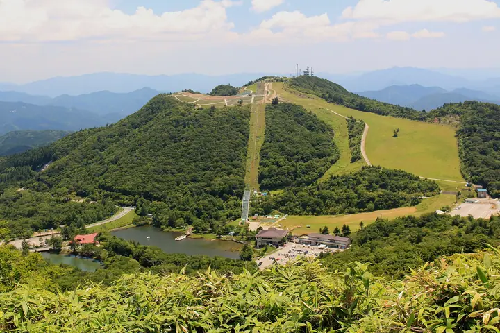
Mt. Hagitarō (1,358 m) rises in Toyone Village in Kitashitara District, Aichi Prefecture, as the second-highest summit in the prefecture after neighboring Mt. Chausu. The peak forms the centerpiece of the Chausuyama Highland Resort, and its "Shibazakura no Oka" hillside blooms with some 400,000 plants of moss phlox in May before yielding to summer-and-autumn Sunpatiens. A scenic lift carries visitors to the top in about thirteen minutes, where the panorama sweeps over the Southern Alps and Central Alps and reaches as far as Hamamatsu and Nagoya on clear days.
Mt. Hagitarō at a glance
- Weather: The most settled day in the next 7 days is Sun, November 8: clear, gusts up to 8 m/s. Fri, Nov 6, Sat, Nov 7: strong wind (gusts up to 18 m/s).
- Route: The shortest is Chausuyama Highlands Circuit: Mount Chausu and Mount Hagitaro: about 2 h 14 min, 5.0 km, about 300 m of climbing.
Mt. Hagitarō weather (hourly, 14 days)
Sunrise today 06:12, sunset 16:54
| Tue, 11/3 | Wed, 11/4 | Thu, 11/5 | Fri, 11/6 | Sat, 11/7 | Sun, 11/8 | Mon, 11/9 | Tue, 11/10 | Wed, 11/11 | Thu, 11/12 | Fri, 11/13 | Sat, 11/14 | Sun, 11/15 | Mon, 11/16 | Tue, 11/17 | |||||||||||||||||||||||||||||||||||||||||||||||||||||||||||||||||||||||
|---|---|---|---|---|---|---|---|---|---|---|---|---|---|---|---|---|---|---|---|---|---|---|---|---|---|---|---|---|---|---|---|---|---|---|---|---|---|---|---|---|---|---|---|---|---|---|---|---|---|---|---|---|---|---|---|---|---|---|---|---|---|---|---|---|---|---|---|---|---|---|---|---|---|---|---|---|---|---|---|---|---|---|---|---|---|
| Japan time | 15 | 17 | 19 | 21 | 23 | 1 | 3 | 5 | 7 | 9 | 11 | 13 | 15 | 18 | 21 | 0 | 3 | 6 | 9 | 12 | 15 | 18 | 21 | 0 | 3 | 6 | 9 | 12 | 15 | 18 | 21 | 0 | 3 | 6 | 9 | 12 | 15 | 18 | 21 | 0 | 3 | 6 | 9 | 12 | 15 | 18 | 21 | 0 | 3 | 6 | 9 | 15 | 21 | 3 | 9 | 15 | 21 | 3 | 9 | 15 | 21 | 3 | 9 | 15 | 21 | 3 | 9 | 15 | 21 | 3 | 9 | 15 | 21 | 3 | 9 | 15 | 21 | 3 | 9 | 15 | 21 | 3 | 9 | 15 | |
 |  |   |   | | | | |   |   |   | |   |   | | | | |   |   | |   | | | | | | | |  | | | | | | | | | | | | | | | | | | | | | | |   | | | | | | | | | | | |  | | | | | | | | | | | | | | | |  | | | | ||
| Temperature | °C | 13° | 8° | 6° | 5° | 5° | 4° | 4° | 4° | 5° | 11° | 13° | 12° | 12° | 9° | 9° | 9° | 9° | 9° | 13° | 15° | 13° | 11° | 11° | 8° | 9° | 10° | 11° | 14° | 12° | 8° | 5° | 4° | 2° | 1° | 5° | 8° | 7° | 3° | 0° | -1° | -1° | -1° | 8° | 10° | 9° | 4° | 5° | 5° | 5° | 4° | 9° | 10° | 2° | 2° | 8° | 8° | 4° | 0° | 3° | 7° | -1° | 0° | 6° | 8° | 0° | 3° | 8° | 9° | 2° | 2° | 7° | 9° | 4° | 6° | 9° | 9° | 8° | 9° | 11° | 13° | 4° | 5° | 7° | 8° |
| Precipitation | mm | 0.2 | 0.2 | 0.5 | 7 | 8 | 0.3 | 0.7 | 1.8 | 1.1 | 0.2 | 0.6 | 0.3 | 0.5 | 0.3 | 0.1 | 1.2 | 22 | 17 | 0.5 | 0.3 | 0.1 | 0.3 | 0.6 | |||||||||||||||||||||||||||||||||||||||||||||||||||||||||||||
| New snow | cm | ||||||||||||||||||||||||||||||||||||||||||||||||||||||||||||||||||||||||||||||||||||
| Snow depth | cm | 0 | 0 | 0 | 0 | 0 | 0 | 0 | 0 | 0 | 0 | 0 | 0 | 0 | 0 | 0 | 0 | 0 | 0 | 0 | 0 | 0 | 0 | 0 | 0 | 0 | 0 | 0 | 0 | 0 | 0 | 0 | 0 | 0 | 0 | 0 | 0 | 0 | 0 | 0 | 0 | 0 | 0 | 0 | 0 | 0 | 0 | 0 | 0 | 0 | 0 | 0 | 0 | 0 | 0 | 0 | 0 | 0 | 0 | 0 | 0 | 0 | 0 | 0 | 0 | 0 | 0 | 0 | 0 | 0 | 0 | 0 | 0 | 0 | 0 | 0 | 0 | 0 | 0 | 0 | 0 | 0 | 0 | 0 | 0 |
| Wind | m/s | 3 | 2 | 0 | 0 | 0 | 0 | 1 | 1 | 1 | 1 | 2 | 2 | 0 | 1 | 2 | 1 | 2 | 3 | 1 | 1 | 1 | 1 | 1 | 1 | 2 | 3 | 5 | 6 | 6 | 6 | 6 | 7 | 7 | 6 | 6 | 7 | 6 | 5 | 3 | 3 | 3 | 2 | 1 | 2 | 2 | 0 | 0 | 0 | 1 | 2 | 2 | 4 | 1 | 1 | 1 | 3 | 4 | 7 | 6 | 5 | 2 | 1 | 1 | 2 | 3 | 3 | 4 | 4 | 2 | 1 | 0 | 3 | 1 | 1 | 2 | 2 | 0 | 2 | 4 | 7 | 3 | 2 | 2 | 4 |
| Wind gusts | m/s | 9 | 9 | 5 | 2 | 2 | 2 | 3 | 3 | 3 | 5 | 5 | 6 | 5 | 4 | 5 | 7 | 7 | 7 | 6 | 6 | 5 | 4 | 4 | 4 | 6 | 8 | 13 | 15 | 15 | 15 | 15 | 16 | 17 | 16 | 16 | 18 | 18 | 16 | 12 | 8 | 7 | 7 | 6 | 7 | 8 | 5 | 2 | 2 | 2 | 4 | 6 | 10 | 9 | 2 | 4 | 10 | 10 | 19 | 21 | 15 | 12 | 5 | 5 | 9 | 7 | 10 | 11 | 11 | 11 | 6 | 4 | 9 | 8 | 4 | 6 | 8 | 8 | 7 | 10 | 18 | 17 | 7 | 6 | 10 |
| Wind dir. | ↓ | ↓ | ↓ | ↓ | ↓ | ↓ | ↓ | ↓ | ↓ | ↓ | ↓ | ↓ | ↓ | ↓ | ↓ | ↓ | ↓ | ↓ | ↓ | ↓ | ↓ | ↓ | ↓ | ↓ | ↓ | ↓ | ↓ | ↓ | ↓ | ↓ | ↓ | ↓ | ↓ | ↓ | ↓ | ↓ | ↓ | ↓ | ↓ | ↓ | ↓ | ↓ | ↓ | ↓ | ↓ | ↓ | ↓ | ↓ | ↓ | ↓ | ↓ | ↓ | ↓ | ↓ | ↓ | ↓ | ↓ | ↓ | ↓ | ↓ | ↓ | ↓ | ↓ | ↓ | ↓ | ↓ | ↓ | ↓ | ↓ | ↓ | ↓ | ↓ | ↓ | ↓ | ↓ | ↓ | ↓ | ↓ | ↓ | ↓ | ↓ | ↓ | ↓ | ↓ | |
Mt. Hagitarō hiking routes
Hiking times are estimates calculated from the terrain.
Huts, campsites and lodging near Mt. Hagitarō
Campsites
- 茶臼山高原キャンプ場
- Chausuyama Highland Camping Village
- Shirakabakōgen Camping Ground
- うるぎ星の森オートキャンプ場
Lodging
- 休暇村茶臼山高原
- 民宿旅館山口屋
- ログバンガロー
Lists that include Mt. Hagitarō
Mt. Hagitarō facts
- Elevation
- 1,358 m
- Location
- Toyone, Aichi
35.214210, 137.657758 - Website
- www.toyonemura-kanko.jp
- Trail Map
- www.honokuni.or.jp (PDF)
- Wikipedia
- ja.wikipedia.org