
Mount Zaru
笊ヶ岳
Hayakawa, Yamanashi · Elevation 2,629 m
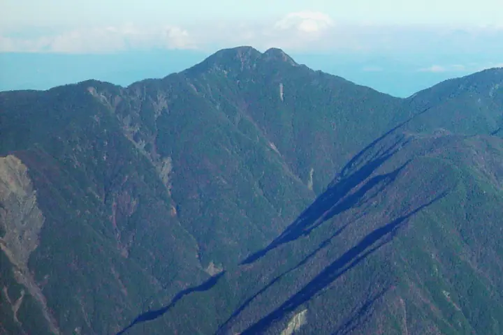
Mount Zaru is a 2,629 m peak straddling Hayakawa Town in Yamanashi Prefecture and Aoi Ward, Shizuoka City, in Shizuoka Prefecture, sitting at the southern end of the Shirane-Nanrei sub-range of the Akaishi (Southern) Alps within Southern Alps National Park. The double summit, said to resemble an inverted bamboo zaru basket, gives the peak its name. Listed in the Nihon Nihyaku Meizan, the Yamanashi Hyakumeizan, and the Shizuoka 100 Mountains, it is famously "the most distant" of the Nihyaku Meizan: the standard route from Oidaira in Amehata, Hayakawa, climbs over Hinoki-yokote-yama and Nunobiki-yama to the summit on a multi-day itinerary that requires confident route-finding, rock work, and snow-section technique — strictly an advanced ascent. The summit panorama spans the southern Akaishi giants of Arakawa, Akaishi, and Hijiri-dake, with Mount Fuji rising directly to the east.
Mount Zaru at a glance
- Weather: The most settled day in the next 7 days is Sun, November 8: clear, gusts up to 9 m/s. Sat, Nov 7: strong wind (gusts up to 15 m/s).
Mount Zaru weather (hourly, 14 days)
Sunrise today 06:10, sunset 16:51
| Tue, 11/3 | Wed, 11/4 | Thu, 11/5 | Fri, 11/6 | Sat, 11/7 | Sun, 11/8 | Mon, 11/9 | Tue, 11/10 | Wed, 11/11 | Thu, 11/12 | Fri, 11/13 | Sat, 11/14 | Sun, 11/15 | Mon, 11/16 | Tue, 11/17 | |||||||||||||||||||||||||||||||||||||||||||||||||||||||||||||||||||||||
|---|---|---|---|---|---|---|---|---|---|---|---|---|---|---|---|---|---|---|---|---|---|---|---|---|---|---|---|---|---|---|---|---|---|---|---|---|---|---|---|---|---|---|---|---|---|---|---|---|---|---|---|---|---|---|---|---|---|---|---|---|---|---|---|---|---|---|---|---|---|---|---|---|---|---|---|---|---|---|---|---|---|---|---|---|---|
| Japan time | 15 | 17 | 19 | 21 | 23 | 1 | 3 | 5 | 7 | 9 | 11 | 13 | 15 | 18 | 21 | 0 | 3 | 6 | 9 | 12 | 15 | 18 | 21 | 0 | 3 | 6 | 9 | 12 | 15 | 18 | 21 | 0 | 3 | 6 | 9 | 12 | 15 | 18 | 21 | 0 | 3 | 6 | 9 | 12 | 15 | 18 | 21 | 0 | 3 | 6 | 9 | 15 | 21 | 3 | 9 | 15 | 21 | 3 | 9 | 15 | 21 | 3 | 9 | 15 | 21 | 3 | 9 | 15 | 21 | 3 | 9 | 15 | 21 | 3 | 9 | 15 | 21 | 3 | 9 | 15 | 21 | 3 | 9 | 15 | |
  |   |   |   | | | | |   |   | |   | |   | | | | |   | | |   | | |   | |  | | |  | | | | | | | | | | | | | | | | | |   | | | | | | | | | |   | | |   |  | | | | | | | | | | | | | | | | | | | | | | | ||
| Temperature | °C | 3° | -2° | -3° | -5° | -6° | -5° | -5° | -4° | -2° | 1° | 4° | 3° | 2° | 0° | 0° | 0° | 1° | 2° | 5° | 9° | 5° | 2° | 1° | -1° | 0° | 0° | 5° | 9° | 7° | -1° | -4° | -5° | -8° | -10° | -2° | 2° | 1° | -6° | -8° | -8° | -8° | -7° | 1° | 3° | 2° | -3° | -3° | -3° | -3° | -4° | 0° | 1° | -6° | -7° | -1° | 0° | -4° | -7° | -3° | 0° | -8° | -8° | -1° | 0° | -7° | -8° | 0° | 1° | -6° | -6° | 0° | 2° | -6° | -5° | 2° | 2° | 1° | 1° | 5° | 7° | -3° | -2° | -1° | 0° |
| Precipitation | mm | 0.5 | 0.3 | 0.4 | 0.9 | 1.5 | 0.4 | 9 | 14 | 8 | 1.2 | 1.4 | 0.6 | 0.9 | 0.1 | 0.9 | 0.1 | 0.2 | 0.1 | 0.3 | 0.2 | 0.8 | 0.7 | 0.1 | 0.3 | 0.3 | 17 | 22 | 0.8 | 1.0 | 0.4 | 0.7 | |||||||||||||||||||||||||||||||||||||||||||||||||||||
| New snow | cm | <.1 | <.1 | ||||||||||||||||||||||||||||||||||||||||||||||||||||||||||||||||||||||||||||||||||
| Snow depth | cm | 0 | 0 | 0 | 0 | 0 | 0 | 0 | 0 | 0 | 0 | 0 | 0 | 0 | 0 | 0 | 0 | 0 | 0 | 0 | 0 | 0 | 0 | 0 | 0 | 0 | 0 | 0 | 0 | 0 | 0 | 0 | 0 | 0 | 0 | 0 | 0 | 0 | 0 | 0 | 0 | 0 | 0 | 0 | 0 | 0 | 0 | 0 | 0 | 0 | 0 | 0 | 0 | 0 | 0 | 0 | 0 | 0 | 0 | 0 | 0 | 0 | 0 | 0 | 0 | 0 | 0 | 0 | 0 | 0 | 0 | 0 | 0 | 0 | 0 | 0 | 0 | 0 | 0 | 0 | 0 | 0 | 0 | 0 | 0 |
| Wind | m/s | 0 | 0 | 1 | 1 | 1 | 1 | 1 | 1 | 1 | 0 | 2 | 1 | 1 | 1 | 1 | 1 | 0 | 1 | 1 | 1 | 1 | 1 | 1 | 2 | 2 | 2 | 2 | 2 | 2 | 2 | 2 | 3 | 3 | 3 | 2 | 2 | 1 | 2 | 2 | 2 | 2 | 1 | 0 | 0 | 1 | 1 | 1 | 1 | 1 | 1 | 1 | 0 | 1 | 1 | 1 | 2 | 2 | 4 | 2 | 1 | 0 | 2 | 1 | 1 | 1 | 1 | 1 | 0 | 1 | 1 | 0 | 0 | 2 | 2 | 1 | 2 | 1 | 2 | 2 | 2 | 0 | 1 | 1 | 1 |
| Wind gusts | m/s | 8 | 8 | 7 | 7 | 7 | 7 | 7 | 7 | 6 | 6 | 8 | 9 | 7 | 6 | 6 | 7 | 11 | 11 | 9 | 8 | 10 | 13 | 9 | 10 | 12 | 12 | 12 | 12 | 11 | 12 | 13 | 15 | 16 | 16 | 15 | 14 | 13 | 11 | 10 | 10 | 10 | 10 | 9 | 7 | 8 | 8 | 8 | 9 | 9 | 9 | 10 | 11 | 8 | 8 | 8 | 13 | 11 | 19 | 19 | 14 | 8 | 8 | 8 | 10 | 8 | 8 | 10 | 10 | 7 | 6 | 6 | 7 | 8 | 8 | 9 | 13 | 14 | 13 | 13 | 13 | 10 | 7 | 5 | 8 |
| Wind dir. | ↓ | ↓ | ↓ | ↓ | ↓ | ↓ | ↓ | ↓ | ↓ | ↓ | ↓ | ↓ | ↓ | ↓ | ↓ | ↓ | ↓ | ↓ | ↓ | ↓ | ↓ | ↓ | ↓ | ↓ | ↓ | ↓ | ↓ | ↓ | ↓ | ↓ | ↓ | ↓ | ↓ | ↓ | ↓ | ↓ | ↓ | ↓ | ↓ | ↓ | ↓ | ↓ | ↓ | ↓ | ↓ | ↓ | ↓ | ↓ | ↓ | ↓ | ↓ | ↓ | ↓ | ↓ | ↓ | ↓ | ↓ | ↓ | ↓ | ↓ | ↓ | ↓ | ↓ | ↓ | ↓ | ↓ | ↓ | ↓ | ↓ | ↓ | ↓ | ↓ | ↓ | ↓ | ↓ | ↓ | ↓ | ↓ | ↓ | ↓ | ↓ | ↓ | ↓ | ↓ | |
Huts, campsites and lodging near Mount Zaru
Mountain huts
Campsites
- さわら島テント場
Lists that include Mount Zaru
Japan 200 Famous Mountains · Japan's 300 Famous Mountains · Yamanashi 100 Famous Mountains · 100 Mountains of Shizuoka · Elevations of 1003 Mountains of Japan · 1000 Mountains of Japan
Mount Zaru facts
- Elevation
- 2,629 m
- Location
- Hayakawa, Yamanashi
35.424164, 138.259479 - National Park
- 南アルプス国立公園
- Website
- www.town.hayakawa.yamanashi.jp
- Trail Map
- www.pref.yamanashi.jp (PDF)
- Wikipedia
- ja.wikipedia.org