
Mount Zaru
笊ヶ岳
ฮายากาวะ, ยามานาชิ · ความสูง 2,629 ม.
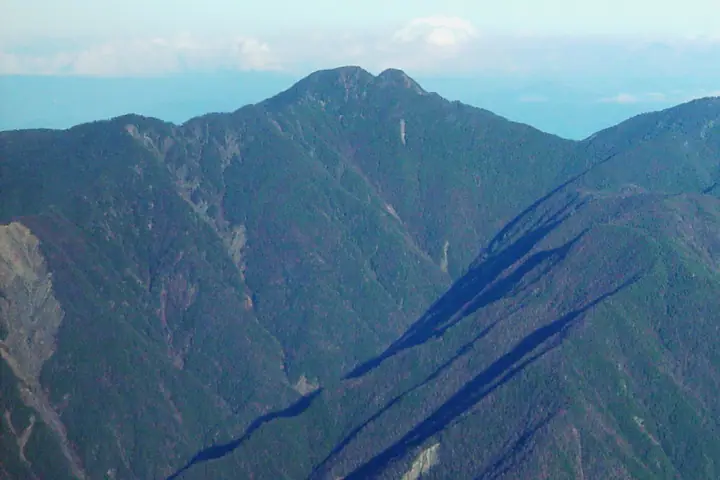
Mount Zaru is a 2,629 m peak straddling Hayakawa Town in Yamanashi Prefecture and Aoi Ward, Shizuoka City, in Shizuoka Prefecture, sitting at the southern end of the Shirane-Nanrei sub-range of the Akaishi (Southern) Alps within Southern Alps National Park. The double summit, said to resemble an inverted bamboo zaru basket, gives the peak its name. Listed in the Nihon Nihyaku Meizan, the Yamanashi Hyakumeizan, and the Shizuoka 100 Mountains, it is famously "the most distant" of the Nihyaku Meizan: the standard route from Oidaira in Amehata, Hayakawa, climbs over Hinoki-yokote-yama and Nunobiki-yama to the summit on a multi-day itinerary that requires confident route-finding, rock work, and snow-section technique — strictly an advanced ascent. The summit panorama spans the southern Akaishi giants of Arakawa, Akaishi, and Hijiri-dake, with Mount Fuji rising directly to the east.
สรุป Mount Zaru
- อากาศ: วันที่อากาศคงที่ที่สุดใน 7 วันข้างหน้าคือ อาทิตย์ 8 พฤศจิกายน: ท้องฟ้าแจ่มใส ลมกระโชกสูงสุด 8 ม./วินาที
อากาศ Mount Zaru (รายชั่วโมง 2 สัปดาห์)
วันนี้พระอาทิตย์ขึ้น 06:10 ตก 16:51
| อังคาร 3/11 | พุธ 4/11 | พฤหัส 5/11 | ศุกร์ 6/11 | เสาร์ 7/11 | อาทิตย์ 8/11 | จันทร์ 9/11 | อังคาร 10/11 | พุธ 11/11 | พฤหัส 12/11 | ศุกร์ 13/11 | เสาร์ 14/11 | อาทิตย์ 15/11 | จันทร์ 16/11 | อังคาร 17/11 | |||||||||||||||||||||||||||||||||||||||||||||||||||||||||||||||||||||||
|---|---|---|---|---|---|---|---|---|---|---|---|---|---|---|---|---|---|---|---|---|---|---|---|---|---|---|---|---|---|---|---|---|---|---|---|---|---|---|---|---|---|---|---|---|---|---|---|---|---|---|---|---|---|---|---|---|---|---|---|---|---|---|---|---|---|---|---|---|---|---|---|---|---|---|---|---|---|---|---|---|---|---|---|---|---|
| เวลาญี่ปุ่น | 21 | 23 | 1 | 3 | 5 | 7 | 9 | 11 | 13 | 15 | 17 | 19 | 21 | 0 | 3 | 6 | 9 | 12 | 15 | 18 | 21 | 0 | 3 | 6 | 9 | 12 | 15 | 18 | 21 | 0 | 3 | 6 | 9 | 12 | 15 | 18 | 21 | 0 | 3 | 6 | 9 | 12 | 15 | 18 | 21 | 0 | 3 | 6 | 9 | 12 | 15 | 21 | 3 | 9 | 15 | 21 | 3 | 9 | 15 | 21 | 3 | 9 | 15 | 21 | 3 | 9 | 15 | 21 | 3 | 9 | 15 | 21 | 3 | 9 | 15 | 21 | 3 | 9 | 15 | 21 | 3 | 9 | 15 | 21 | |
  |  |   | | |   |   |   |   | |   | | | | | |   |   | |   |   | | | | |  | | | |  | | | | | | | | | | | | | | | | | | | | | | | | | | |   | | |   |  | | | | | | | | | | | | | | | | | | | | | | | | ||
| อุณหภูมิ | °C | -5° | -6° | -6° | -6° | -5° | -2° | 3° | 3° | 3° | 2° | 0° | 0° | 0° | 0° | 1° | 2° | 6° | 10° | 6° | 3° | 2° | 0° | 2° | 1° | 5° | 8° | 6° | -1° | -4° | -5° | -7° | -9° | -1° | 1° | 0° | -6° | -8° | -8° | -7° | -6° | 1° | 3° | 2° | -2° | -4° | -2° | -1° | -1° | 0° | 3° | 3° | -6° | -7° | -1° | 0° | -4° | -7° | -3° | 0° | -8° | -8° | -1° | 0° | -7° | -8° | 0° | 1° | -6° | -6° | 0° | 2° | -6° | -5° | 2° | 2° | 1° | 1° | 5° | 7° | -3° | -2° | -1° | 0° | -4° |
| ฝนและหิมะ | mm | 0.3 | 0.4 | 0.9 | 1.0 | 1.5 | 3.6 | 11 | 12 | 6 | 0.3 | 0.2 | 0.7 | 0.3 | 0.5 | 0.5 | 0.4 | 0.8 | 0.4 | 0.2 | 0.1 | 0.3 | 0.2 | 0.8 | 0.7 | 0.1 | 0.3 | 0.3 | 17 | 22 | 0.8 | 1.0 | 0.4 | 0.7 | |||||||||||||||||||||||||||||||||||||||||||||||||||
| หิมะตก | cm | <.1 | |||||||||||||||||||||||||||||||||||||||||||||||||||||||||||||||||||||||||||||||||||
| หิมะสะสม | cm | 0 | 0 | 0 | 0 | 0 | 0 | 0 | 0 | 0 | 0 | 0 | 0 | 0 | 0 | 0 | 0 | 0 | 0 | 0 | 0 | 0 | 0 | 0 | 0 | 0 | 0 | 0 | 0 | 0 | 0 | 0 | 0 | 0 | 0 | 0 | 0 | 0 | 0 | 0 | 0 | 0 | 0 | 0 | 0 | 0 | 0 | 0 | 0 | 0 | 0 | 0 | 0 | 0 | 0 | 0 | 0 | 0 | 0 | 0 | 0 | 0 | 0 | 0 | 0 | 0 | 0 | 0 | 0 | 0 | 0 | 0 | 0 | 0 | 0 | 0 | 0 | 0 | 0 | 0 | 0 | 0 | 0 | 0 | 0 |
| ลม | m/s | 1 | 1 | 1 | 1 | 1 | 1 | 1 | 1 | 1 | 1 | 1 | 1 | 1 | 0 | 1 | 1 | 1 | 1 | 0 | 1 | 1 | 2 | 2 | 2 | 1 | 1 | 2 | 2 | 3 | 2 | 3 | 3 | 2 | 2 | 1 | 1 | 1 | 1 | 1 | 1 | 0 | 1 | 1 | 0 | 1 | 1 | 1 | 1 | 1 | 1 | 1 | 1 | 1 | 1 | 2 | 2 | 4 | 2 | 1 | 0 | 2 | 1 | 1 | 1 | 1 | 1 | 0 | 1 | 1 | 0 | 0 | 2 | 2 | 1 | 2 | 1 | 2 | 2 | 2 | 0 | 1 | 1 | 1 | 1 |
| ลมกระโชก | m/s | 7 | 7 | 7 | 7 | 7 | 6 | 7 | 8 | 7 | 6 | 6 | 6 | 6 | 8 | 11 | 11 | 8 | 9 | 9 | 7 | 9 | 12 | 15 | 15 | 11 | 11 | 11 | 13 | 14 | 13 | 15 | 15 | 15 | 14 | 13 | 11 | 10 | 10 | 9 | 9 | 8 | 7 | 8 | 8 | 9 | 10 | 11 | 10 | 10 | 11 | 11 | 8 | 8 | 8 | 13 | 11 | 19 | 19 | 14 | 8 | 8 | 8 | 10 | 8 | 8 | 10 | 10 | 7 | 6 | 6 | 7 | 8 | 8 | 9 | 13 | 14 | 13 | 13 | 13 | 10 | 7 | 5 | 8 | 7 |
| ทิศทางลม | ↓ | ↓ | ↓ | ↓ | ↓ | ↓ | ↓ | ↓ | ↓ | ↓ | ↓ | ↓ | ↓ | ↓ | ↓ | ↓ | ↓ | ↓ | ↓ | ↓ | ↓ | ↓ | ↓ | ↓ | ↓ | ↓ | ↓ | ↓ | ↓ | ↓ | ↓ | ↓ | ↓ | ↓ | ↓ | ↓ | ↓ | ↓ | ↓ | ↓ | ↓ | ↓ | ↓ | ↓ | ↓ | ↓ | ↓ | ↓ | ↓ | ↓ | ↓ | ↓ | ↓ | ↓ | ↓ | ↓ | ↓ | ↓ | ↓ | ↓ | ↓ | ↓ | ↓ | ↓ | ↓ | ↓ | ↓ | ↓ | ↓ | ↓ | ↓ | ↓ | ↓ | ↓ | ↓ | ↓ | ↓ | ↓ | ↓ | ↓ | ↓ | ↓ | ↓ | ↓ | |
กระท่อม ที่ตั้งแคมป์ และที่พักใกล้ Mount Zaru
กระท่อมบนภูเขา
ที่ตั้งแคมป์
- さわら島テント場
รายชื่อที่มี Mount Zaru
200 ภูเขาที่มีชื่อเสียงของญี่ปุ่น · 300 ภูเขาที่มีชื่อเสียงของญี่ปุ่น · 100 ภูเขาที่มีชื่อเสียงของยามานาชิ · 100 ภูเขาแห่งชิซูโอกะ · ระดับความสูงของภูเขา 1003 แห่งในญี่ปุ่น · ภูเขา 1000 แห่งของญี่ปุ่น
ข้อมูลพื้นฐาน Mount Zaru
- ความสูง
- 2,629 ม.
- ที่ตั้ง
- ฮายากาวะ, ยามานาชิ
35.424164, 138.259479 - อุทยานแห่งชาติ
- 南アルプス国立公園
- เว็บไซต์
- www.town.hayakawa.yamanashi.jp
- แผนที่เส้นทางเดินเขา
- www.pref.yamanashi.jp (PDF)
- วิกิพีเดีย
- ja.wikipedia.org