
Mount Wanakura
和名倉山
Chichibu, Saitama · Elevation 2,036 m
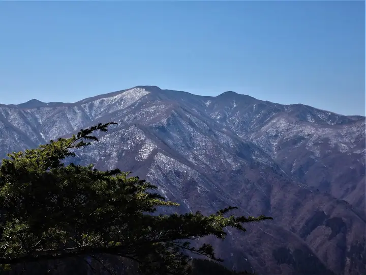
Mount Wanakura is a 2,036.02 m peak in Chichibu City (formerly Ōtaki Village), Saitama Prefecture—a remote massif rising on the northern flank of the Oku-Chichibu main ridge. The Geospatial Information Authority of Japan labels it "Mount Shiraishi" on official topographic maps, while "Wanakura" is the older Chichibu-side name. Listed in the Nihon Nihyaku Meizan and the Kantō Hyakumeizan, the mountain was once celebrated for its primeval forest, but extensive logging and wildfires in the 1950s and 60s damaged the slopes. The standard line is the round trip from Shōkan Pass via Shōkan-goya on the Yamanashi side, taking eight to nine hours; the Saitama-side approaches—the Futase, Hirumeshi, Senba, and Nita-goya ridge routes—are unmaintained and demand topographic-map and GPS skills, making Wanakura one of Oku-Chichibu's most demanding and benightment-prone peaks.
Mount Wanakura at a glance
- Weather: The most settled day in the next 7 days is Sun, November 8: clear, gusts up to 6 m/s.
Mount Wanakura weather (hourly, 14 days)
Sunrise today 06:08, sunset 16:48
| Tue, 11/3 | Wed, 11/4 | Thu, 11/5 | Fri, 11/6 | Sat, 11/7 | Sun, 11/8 | Mon, 11/9 | Tue, 11/10 | Wed, 11/11 | Thu, 11/12 | Fri, 11/13 | Sat, 11/14 | Sun, 11/15 | Mon, 11/16 | Tue, 11/17 | |||||||||||||||||||||||||||||||||||||||||||||||||||||||||||||||||||||||
|---|---|---|---|---|---|---|---|---|---|---|---|---|---|---|---|---|---|---|---|---|---|---|---|---|---|---|---|---|---|---|---|---|---|---|---|---|---|---|---|---|---|---|---|---|---|---|---|---|---|---|---|---|---|---|---|---|---|---|---|---|---|---|---|---|---|---|---|---|---|---|---|---|---|---|---|---|---|---|---|---|---|---|---|---|---|
| Japan time | 15 | 17 | 19 | 21 | 23 | 1 | 3 | 5 | 7 | 9 | 11 | 13 | 15 | 18 | 21 | 0 | 3 | 6 | 9 | 12 | 15 | 18 | 21 | 0 | 3 | 6 | 9 | 12 | 15 | 18 | 21 | 0 | 3 | 6 | 9 | 12 | 15 | 18 | 21 | 0 | 3 | 6 | 9 | 12 | 15 | 18 | 21 | 0 | 3 | 6 | 9 | 15 | 21 | 3 | 9 | 15 | 21 | 3 | 9 | 15 | 21 | 3 | 9 | 15 | 21 | 3 | 9 | 15 | 21 | 3 | 9 | 15 | 21 | 3 | 9 | 15 | 21 | 3 | 9 | 15 | 21 | 3 | 9 | 15 | |
  |   | | | | |   | |   | | | | | | | | | | |   | | |   |  | | |  | | |   | | | | | | | |   | | | | | | |   | | | | | | | | |   |   |   | | | | |   |  | | | | | | | | | | | | | | | |   | |   | | | | | ||
| Temperature | °C | 4° | 3° | 3° | 3° | 2° | 2° | 2° | 2° | 2° | 3° | 5° | 5° | 4° | 3° | 3° | 3° | 3° | 4° | 6° | 11° | 8° | 6° | 4° | 4° | 3° | 3° | 10° | 14° | 13° | 5° | 2° | 0° | -2° | -2° | 4° | 6° | 6° | -1° | -3° | -2° | -2° | -3° | 4° | 7° | 4° | -1° | 1° | 0° | 0° | 0° | 3° | 2° | -1° | -2° | -1° | 3° | -1° | -5° | 0° | 0° | -6° | -4° | 2° | 4° | -1° | -5° | 3° | 5° | -4° | -4° | 3° | 5° | -3° | -3° | 4° | 6° | 4° | 4° | 10° | 10° | -1° | 1° | 1° | 2° |
| Precipitation | mm | 1.4 | 0.4 | 0.4 | 1.5 | 1.7 | 1.4 | 0.2 | 1.4 | 0.3 | 6 | 12 | 11 | 1.1 | 1.4 | 0.5 | 0.1 | 1.2 | 2.2 | 4.7 | 1.2 | 0.1 | 0.1 | 9 | 14 | 0.1 | 0.3 | ||||||||||||||||||||||||||||||||||||||||||||||||||||||||||
| New snow | cm | 1.7 | 0.6 | ||||||||||||||||||||||||||||||||||||||||||||||||||||||||||||||||||||||||||||||||||
| Snow depth | cm | 0 | 0 | 0 | 0 | 0 | 0 | 0 | 0 | 0 | 0 | 0 | 0 | 0 | 0 | 0 | 0 | 0 | 0 | 0 | 0 | 0 | 0 | 0 | 0 | 0 | 0 | 0 | 0 | 0 | 0 | 0 | 0 | 0 | 0 | 0 | 0 | 0 | 0 | 0 | 0 | 0 | 0 | 0 | 0 | 0 | 0 | 0 | 0 | 0 | 0 | 0 | 0 | 0 | 1 | 1 | <1 | 0 | 0 | 0 | 0 | 0 | 0 | 0 | 0 | 0 | 0 | 0 | 0 | 0 | 0 | 0 | 0 | 0 | 0 | 0 | 0 | 0 | 0 | 0 | 0 | 0 | 0 | 0 | 0 |
| Wind | m/s | 1 | 1 | 0 | 1 | 0 | 0 | 1 | 1 | 1 | 0 | 1 | 2 | 1 | 1 | 1 | 1 | 1 | 1 | 2 | 1 | 2 | 1 | 1 | 1 | 1 | 1 | 1 | 1 | 0 | 1 | 1 | 0 | 1 | 1 | 1 | 3 | 1 | 0 | 1 | 1 | 0 | 1 | 0 | 1 | 1 | 0 | 1 | 1 | 1 | 1 | 1 | 1 | 1 | 0 | 0 | 2 | 1 | 1 | 6 | 4 | 1 | 1 | 1 | 1 | 1 | 1 | 3 | 1 | 1 | 1 | 1 | 1 | 1 | 1 | 2 | 2 | 2 | 3 | 1 | 3 | 2 | 1 | 1 | 1 |
| Wind gusts | m/s | 5 | 4 | 3 | 3 | 3 | 3 | 3 | 4 | 4 | 4 | 5 | 6 | 6 | 6 | 6 | 6 | 6 | 8 | 6 | 6 | 7 | 8 | 6 | 6 | 6 | 6 | 6 | 7 | 7 | 5 | 5 | 5 | 7 | 7 | 8 | 12 | 11 | 7 | 5 | 6 | 6 | 5 | 5 | 6 | 6 | 5 | 6 | 7 | 6 | 6 | 6 | 6 | 5 | 4 | 5 | 9 | 8 | 8 | 21 | 23 | 15 | 6 | 6 | 8 | 6 | 5 | 10 | 12 | 6 | 4 | 4 | 6 | 6 | 6 | 9 | 13 | 10 | 12 | 12 | 10 | 14 | 7 | 5 | 6 |
| Wind dir. | ↓ | ↓ | ↓ | ↓ | ↓ | ↓ | ↓ | ↓ | ↓ | ↓ | ↓ | ↓ | ↓ | ↓ | ↓ | ↓ | ↓ | ↓ | ↓ | ↓ | ↓ | ↓ | ↓ | ↓ | ↓ | ↓ | ↓ | ↓ | ↓ | ↓ | ↓ | ↓ | ↓ | ↓ | ↓ | ↓ | ↓ | ↓ | ↓ | ↓ | ↓ | ↓ | ↓ | ↓ | ↓ | ↓ | ↓ | ↓ | ↓ | ↓ | ↓ | ↓ | ↓ | ↓ | ↓ | ↓ | ↓ | ↓ | ↓ | ↓ | ↓ | ↓ | ↓ | ↓ | ↓ | ↓ | ↓ | ↓ | ↓ | ↓ | ↓ | ↓ | ↓ | ↓ | ↓ | ↓ | ↓ | ↓ | ↓ | ↓ | ↓ | ↓ | ↓ | ↓ | |
Huts, campsites and lodging near Mount Wanakura
Mountain huts
Lists that include Mount Wanakura
Japan 200 Famous Mountains · Japan's 300 Famous Mountains · Kanto 100 Famous Mountains · 50 Mountains of Saitama Prefecture · Elevations of 1003 Mountains of Japan · 1000 Mountains of Japan
Mount Wanakura facts
- Also known as
- 白石山
- Elevation
- 2,036 m
- Location
- Chichibu, Saitama
35.899423, 138.877997 - Wikipedia
- ja.wikipedia.org