
Mount Wanakura
和名倉山
ชิจิบุ, ไซตามะ · ความสูง 2,036 ม.
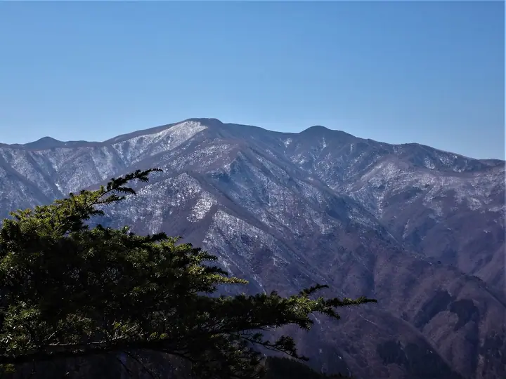
Mount Wanakura is a 2,036.02 m peak in Chichibu City (formerly Ōtaki Village), Saitama Prefecture—a remote massif rising on the northern flank of the Oku-Chichibu main ridge. The Geospatial Information Authority of Japan labels it "Mount Shiraishi" on official topographic maps, while "Wanakura" is the older Chichibu-side name. Listed in the Nihon Nihyaku Meizan and the Kantō Hyakumeizan, the mountain was once celebrated for its primeval forest, but extensive logging and wildfires in the 1950s and 60s damaged the slopes. The standard line is the round trip from Shōkan Pass via Shōkan-goya on the Yamanashi side, taking eight to nine hours; the Saitama-side approaches—the Futase, Hirumeshi, Senba, and Nita-goya ridge routes—are unmaintained and demand topographic-map and GPS skills, making Wanakura one of Oku-Chichibu's most demanding and benightment-prone peaks.
สรุป Mount Wanakura
- อากาศ: วันที่อากาศคงที่ที่สุดใน 7 วันข้างหน้าคือ อาทิตย์ 8 พฤศจิกายน: ท้องฟ้าแจ่มใส ลมกระโชกสูงสุด 6 ม./วินาที
อากาศ Mount Wanakura (รายชั่วโมง 2 สัปดาห์)
วันนี้พระอาทิตย์ขึ้น 06:08 ตก 16:48
| อังคาร 3/11 | พุธ 4/11 | พฤหัส 5/11 | ศุกร์ 6/11 | เสาร์ 7/11 | อาทิตย์ 8/11 | จันทร์ 9/11 | อังคาร 10/11 | พุธ 11/11 | พฤหัส 12/11 | ศุกร์ 13/11 | เสาร์ 14/11 | อาทิตย์ 15/11 | จันทร์ 16/11 | อังคาร 17/11 | |||||||||||||||||||||||||||||||||||||||||||||||||||||||||||||||||||||||
|---|---|---|---|---|---|---|---|---|---|---|---|---|---|---|---|---|---|---|---|---|---|---|---|---|---|---|---|---|---|---|---|---|---|---|---|---|---|---|---|---|---|---|---|---|---|---|---|---|---|---|---|---|---|---|---|---|---|---|---|---|---|---|---|---|---|---|---|---|---|---|---|---|---|---|---|---|---|---|---|---|---|---|---|---|---|
| เวลาญี่ปุ่น | 15 | 17 | 19 | 21 | 23 | 1 | 3 | 5 | 7 | 9 | 11 | 13 | 15 | 18 | 21 | 0 | 3 | 6 | 9 | 12 | 15 | 18 | 21 | 0 | 3 | 6 | 9 | 12 | 15 | 18 | 21 | 0 | 3 | 6 | 9 | 12 | 15 | 18 | 21 | 0 | 3 | 6 | 9 | 12 | 15 | 18 | 21 | 0 | 3 | 6 | 9 | 15 | 21 | 3 | 9 | 15 | 21 | 3 | 9 | 15 | 21 | 3 | 9 | 15 | 21 | 3 | 9 | 15 | 21 | 3 | 9 | 15 | 21 | 3 | 9 | 15 | 21 | 3 | 9 | 15 | 21 | 3 | 9 | 15 | |
  |   | | | | |   | |   | | | | | | | | | | |   | | |   |  | | |  | | |   | | | | | | | |   | | | | | | |   | | | | | | | | |   |   |   | | | | |   |  | | | | | | | | | | | | | | | |   | |   | | | | | ||
| อุณหภูมิ | °C | 4° | 3° | 3° | 3° | 2° | 2° | 2° | 2° | 2° | 3° | 5° | 5° | 4° | 3° | 3° | 3° | 3° | 4° | 6° | 11° | 8° | 6° | 4° | 4° | 3° | 3° | 10° | 14° | 13° | 5° | 2° | 0° | -2° | -2° | 4° | 6° | 6° | -1° | -3° | -2° | -2° | -3° | 4° | 7° | 4° | -1° | 1° | 0° | 0° | 0° | 3° | 2° | -1° | -2° | -1° | 3° | -1° | -5° | 0° | 0° | -6° | -4° | 2° | 4° | -1° | -5° | 3° | 5° | -4° | -4° | 3° | 5° | -3° | -3° | 4° | 6° | 4° | 4° | 10° | 10° | -1° | 1° | 1° | 2° |
| ฝนและหิมะ | mm | 1.4 | 0.4 | 0.4 | 1.5 | 1.7 | 1.4 | 0.2 | 1.4 | 0.3 | 6 | 12 | 11 | 1.1 | 1.4 | 0.5 | 0.1 | 1.2 | 2.2 | 4.7 | 1.2 | 0.1 | 0.1 | 9 | 14 | 0.1 | 0.3 | ||||||||||||||||||||||||||||||||||||||||||||||||||||||||||
| หิมะตก | cm | 1.7 | 0.6 | ||||||||||||||||||||||||||||||||||||||||||||||||||||||||||||||||||||||||||||||||||
| หิมะสะสม | cm | 0 | 0 | 0 | 0 | 0 | 0 | 0 | 0 | 0 | 0 | 0 | 0 | 0 | 0 | 0 | 0 | 0 | 0 | 0 | 0 | 0 | 0 | 0 | 0 | 0 | 0 | 0 | 0 | 0 | 0 | 0 | 0 | 0 | 0 | 0 | 0 | 0 | 0 | 0 | 0 | 0 | 0 | 0 | 0 | 0 | 0 | 0 | 0 | 0 | 0 | 0 | 0 | 0 | 1 | 1 | <1 | 0 | 0 | 0 | 0 | 0 | 0 | 0 | 0 | 0 | 0 | 0 | 0 | 0 | 0 | 0 | 0 | 0 | 0 | 0 | 0 | 0 | 0 | 0 | 0 | 0 | 0 | 0 | 0 |
| ลม | m/s | 1 | 1 | 0 | 1 | 0 | 0 | 1 | 1 | 1 | 0 | 1 | 2 | 1 | 1 | 1 | 1 | 1 | 1 | 2 | 1 | 2 | 1 | 1 | 1 | 1 | 1 | 1 | 1 | 0 | 1 | 1 | 0 | 1 | 1 | 1 | 3 | 1 | 0 | 1 | 1 | 0 | 1 | 0 | 1 | 1 | 0 | 1 | 1 | 1 | 1 | 1 | 1 | 1 | 0 | 0 | 2 | 1 | 1 | 6 | 4 | 1 | 1 | 1 | 1 | 1 | 1 | 3 | 1 | 1 | 1 | 1 | 1 | 1 | 1 | 2 | 2 | 2 | 3 | 1 | 3 | 2 | 1 | 1 | 1 |
| ลมกระโชก | m/s | 5 | 4 | 3 | 3 | 3 | 3 | 3 | 4 | 4 | 4 | 5 | 6 | 6 | 6 | 6 | 6 | 6 | 8 | 6 | 6 | 7 | 8 | 6 | 6 | 6 | 6 | 6 | 7 | 7 | 5 | 5 | 5 | 7 | 7 | 8 | 12 | 11 | 7 | 5 | 6 | 6 | 5 | 5 | 6 | 6 | 5 | 6 | 7 | 6 | 6 | 6 | 6 | 5 | 4 | 5 | 9 | 8 | 8 | 21 | 23 | 15 | 6 | 6 | 8 | 6 | 5 | 10 | 12 | 6 | 4 | 4 | 6 | 6 | 6 | 9 | 13 | 10 | 12 | 12 | 10 | 14 | 7 | 5 | 6 |
| ทิศทางลม | ↓ | ↓ | ↓ | ↓ | ↓ | ↓ | ↓ | ↓ | ↓ | ↓ | ↓ | ↓ | ↓ | ↓ | ↓ | ↓ | ↓ | ↓ | ↓ | ↓ | ↓ | ↓ | ↓ | ↓ | ↓ | ↓ | ↓ | ↓ | ↓ | ↓ | ↓ | ↓ | ↓ | ↓ | ↓ | ↓ | ↓ | ↓ | ↓ | ↓ | ↓ | ↓ | ↓ | ↓ | ↓ | ↓ | ↓ | ↓ | ↓ | ↓ | ↓ | ↓ | ↓ | ↓ | ↓ | ↓ | ↓ | ↓ | ↓ | ↓ | ↓ | ↓ | ↓ | ↓ | ↓ | ↓ | ↓ | ↓ | ↓ | ↓ | ↓ | ↓ | ↓ | ↓ | ↓ | ↓ | ↓ | ↓ | ↓ | ↓ | ↓ | ↓ | ↓ | ↓ | |
กระท่อม ที่ตั้งแคมป์ และที่พักใกล้ Mount Wanakura
กระท่อมบนภูเขา
รายชื่อที่มี Mount Wanakura
200 ภูเขาที่มีชื่อเสียงของญี่ปุ่น · 300 ภูเขาที่มีชื่อเสียงของญี่ปุ่น · 100 ภูเขาที่มีชื่อเสียงของคันโต · ภูเขา 50 แห่งในจังหวัดไซตามะ · ระดับความสูงของภูเขา 1003 แห่งในญี่ปุ่น · ภูเขา 1000 แห่งของญี่ปุ่น
ข้อมูลพื้นฐาน Mount Wanakura
- ชื่ออื่น
- 白石山
- ความสูง
- 2,036 ม.
- ที่ตั้ง
- ชิจิบุ, ไซตามะ
35.899423, 138.877997 - วิกิพีเดีย
- ja.wikipedia.org