
Mt. Kirimogamine
霧藻ケ峰
Chichibu, Saitama · Elevation 1,523 m
Kirimogamine is a 1,523 m ridge peak in Chichibu City, Saitama Prefecture, lying within Chichibu-Tama-Kai National Park. Originally known as Kuroiwayama / Tsubameiwa, the current name was bestowed by Prince Chichibu Yasuhito after his ascent in 1933. It is an important way-station on the Okuchichibu ridge route from Mitsumine Shrine to Mount Kumotori, with the Kirimogamine rest hut standing just below the summit, and the peak appears in the Saitama 50 selection.
Mt. Kirimogamine at a glance
- Weather: The most settled day in the next 7 days is Fri, November 6: clear, gusts up to 8 m/s.
- Route: The shortest is Mount Kumotori Return from Mitsumine Shrine via the Mitsumine Route: about 12 h 11 min, 19.2 km, about 1,760 m of climbing.
Mt. Kirimogamine weather (hourly, 14 days)
Sunrise today 06:08, sunset 16:48
| Tue, 11/3 | Wed, 11/4 | Thu, 11/5 | Fri, 11/6 | Sat, 11/7 | Sun, 11/8 | Mon, 11/9 | Tue, 11/10 | Wed, 11/11 | Thu, 11/12 | Fri, 11/13 | Sat, 11/14 | Sun, 11/15 | Mon, 11/16 | Tue, 11/17 | |||||||||||||||||||||||||||||||||||||||||||||||||||||||||||||||||||||||
|---|---|---|---|---|---|---|---|---|---|---|---|---|---|---|---|---|---|---|---|---|---|---|---|---|---|---|---|---|---|---|---|---|---|---|---|---|---|---|---|---|---|---|---|---|---|---|---|---|---|---|---|---|---|---|---|---|---|---|---|---|---|---|---|---|---|---|---|---|---|---|---|---|---|---|---|---|---|---|---|---|---|---|---|---|---|
| Japan time | 15 | 17 | 19 | 21 | 23 | 1 | 3 | 5 | 7 | 9 | 11 | 13 | 15 | 18 | 21 | 0 | 3 | 6 | 9 | 12 | 15 | 18 | 21 | 0 | 3 | 6 | 9 | 12 | 15 | 18 | 21 | 0 | 3 | 6 | 9 | 12 | 15 | 18 | 21 | 0 | 3 | 6 | 9 | 12 | 15 | 18 | 21 | 0 | 3 | 6 | 9 | 15 | 21 | 3 | 9 | 15 | 21 | 3 | 9 | 15 | 21 | 3 | 9 | 15 | 21 | 3 | 9 | 15 | 21 | 3 | 9 | 15 | 21 | 3 | 9 | 15 | 21 | 3 | 9 | 15 | 21 | 3 | 9 | 15 | |
  |   |   |   | | | | |   | | | | | | | | | | |   |   | | |   |  | |  |   | |   | | | | | | | | | | | | | |   | | | | | | | | | | | | | | | | |   |  | | | | | | | | | | | | | | | |   | | | | | | | ||
| Temperature | °C | 6° | 4° | 4° | 4° | 3° | 3° | 3° | 3° | 3° | 4° | 6° | 5° | 4° | 2° | 2° | 3° | 3° | 4° | 6° | 12° | 8° | 6° | 4° | 4° | 4° | 5° | 11° | 15° | 13° | 7° | 4° | 2° | 0° | -1° | 6° | 9° | 7° | 1° | -1° | -3° | -3° | -3° | 3° | 7° | 4° | 0° | 1° | 0° | 0° | 0° | 2° | 3° | 1° | 0° | 1° | 3° | 0° | -4° | 2° | 2° | -3° | -5° | 2° | 3° | 0° | -4° | 5° | 5° | -4° | -6° | 2° | 4° | -3° | -4° | 4° | 6° | 3° | 3° | 10° | 10° | 2° | -1° | 1° | 2° |
| Precipitation | mm | 0.2 | 0.3 | 0.5 | 0.6 | 0.2 | 0.3 | 0.2 | 0.2 | 0.6 | 0.4 | 5.0 | 11 | 11 | 1.2 | 1.6 | 0.4 | 0.2 | 0.4 | 0.8 | 0.2 | 0.5 | 1.2 | 4.3 | 1.5 | 0.3 | 4.1 | 12 | 0.2 | ||||||||||||||||||||||||||||||||||||||||||||||||||||||||
| New snow | cm | <.1 | <.1 | ||||||||||||||||||||||||||||||||||||||||||||||||||||||||||||||||||||||||||||||||||
| Snow depth | cm | 0 | 0 | 0 | 0 | 0 | 0 | 0 | 0 | 0 | 0 | 0 | 0 | 0 | 0 | 0 | 0 | 0 | 0 | 0 | 0 | 0 | 0 | 0 | 0 | 0 | 0 | 0 | 0 | 0 | 0 | 0 | 0 | 0 | 0 | 0 | 0 | 0 | 0 | 0 | 0 | 0 | 0 | 0 | 0 | 0 | 0 | 0 | 0 | 0 | 0 | 0 | 0 | 0 | <1 | <1 | <1 | 0 | 0 | 0 | 0 | 0 | 0 | 0 | 0 | 0 | 0 | 0 | 0 | 0 | 0 | 0 | 0 | 0 | 0 | 0 | 0 | 0 | 0 | 0 | 0 | 0 | 0 | 0 | 0 |
| Wind | m/s | 2 | 1 | 0 | 0 | 1 | 1 | 1 | 0 | 1 | 1 | 2 | 2 | 2 | 2 | 1 | 1 | 1 | 0 | 1 | 1 | 1 | 0 | 1 | 0 | 1 | 1 | 1 | 2 | 3 | 0 | 1 | 1 | 1 | 1 | 2 | 2 | 3 | 1 | 0 | 0 | 1 | 0 | 1 | 2 | 3 | 0 | 0 | 1 | 1 | 0 | 2 | 2 | 1 | 1 | 2 | 3 | 1 | 1 | 7 | 5 | 2 | 1 | 1 | 3 | 0 | 1 | 4 | 4 | 1 | 0 | 1 | 2 | 0 | 1 | 0 | 2 | 0 | 0 | 0 | 5 | 3 | 0 | 2 | 3 |
| Wind gusts | m/s | 7 | 6 | 2 | 2 | 2 | 3 | 3 | 3 | 2 | 4 | 6 | 7 | 7 | 6 | 5 | 4 | 3 | 5 | 4 | 5 | 6 | 4 | 3 | 3 | 3 | 3 | 3 | 7 | 8 | 8 | 3 | 5 | 5 | 5 | 6 | 9 | 9 | 9 | 3 | 3 | 3 | 3 | 5 | 8 | 9 | 7 | 2 | 3 | 3 | 3 | 5 | 8 | 5 | 5 | 6 | 9 | 8 | 6 | 23 | 22 | 17 | 6 | 5 | 10 | 8 | 4 | 12 | 15 | 11 | 5 | 5 | 8 | 6 | 3 | 3 | 7 | 4 | 5 | 5 | 14 | 15 | 10 | 6 | 9 |
| Wind dir. | ↓ | ↓ | ↓ | ↓ | ↓ | ↓ | ↓ | ↓ | ↓ | ↓ | ↓ | ↓ | ↓ | ↓ | ↓ | ↓ | ↓ | ↓ | ↓ | ↓ | ↓ | ↓ | ↓ | ↓ | ↓ | ↓ | ↓ | ↓ | ↓ | ↓ | ↓ | ↓ | ↓ | ↓ | ↓ | ↓ | ↓ | ↓ | ↓ | ↓ | ↓ | ↓ | ↓ | ↓ | ↓ | ↓ | ↓ | ↓ | ↓ | ↓ | ↓ | ↓ | ↓ | ↓ | ↓ | ↓ | ↓ | ↓ | ↓ | ↓ | ↓ | ↓ | ↓ | ↓ | ↓ | ↓ | ↓ | ↓ | ↓ | ↓ | ↓ | ↓ | ↓ | ↓ | ↓ | ↓ | ↓ | ↓ | ↓ | ↓ | ↓ | ↓ | ↓ | ↓ | |
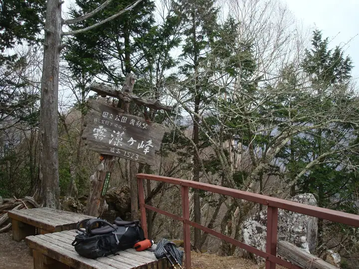
Mt. Kirimogamine hiking routes
Hiking times are estimates calculated from the terrain.
Huts, campsites and lodging near Mt. Kirimogamine
Mountain huts
- Shiraiwa Hut (Ruined)
- Kumotori-Sanso Lodge 2026: open all year · reservation required
Campsites
- 雲取山荘テント場
- つちうちキャンプ場
Lodging
- 興雲閣
- Kaniwa
- Kanba Budokan
Lists that include Mt. Kirimogamine
Mt. Kirimogamine facts
- Also known as
- 黒岩山・燕岩
- Elevation
- 1,523 m
- Location
- Chichibu, Saitama
35.903560, 138.953211 - National Park
- 秩父多摩甲斐国立公園
- Website
- www.chichibuji.gr.jp
- Wikipedia
- ja.wikipedia.org