
Mount Tawarayama
俵山
Nishihara, Kumamoto / Minamiaso, Kumamoto · Elevation 1,095 m
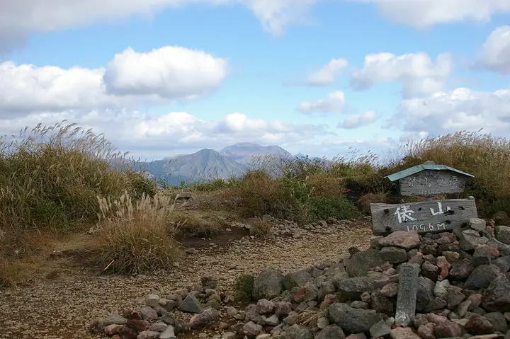
Mount Tawarayama (1,095 m) straddles Nishihara and Minamiaso villages in Kumamoto Prefecture and forms the western end of the Aso caldera rim within Aso-Kuju National Park. Its name comes from its resemblance to stacked rice bales when seen from the Nango Valley, and its broad silvergrass slopes, maintained by spring burning, offer views of the Aso mountains. Maintained trails lead from the Tawarayama Pass viewpoint, Jizo Pass and Moe-no-Sato, with the local tourism association helping maintain the routes. The ten-turbine Aso Nishihara Wind Farm was established on its western flank in 2005 but ceased operation in January 2023.
Mount Tawarayama at a glance
- Weather: The most settled day in the next 7 days is Sun, November 8: clear, gusts up to 6 m/s.
- Route: The shortest is Mount Tawara Return from Tawarayama Pass Viewpoint: about 3 h 43 min, 6.5 km, about 450 m of climbing.
Mount Tawarayama weather (hourly, 14 days)
Sunrise today 06:35, sunset 17:25
| Tue, 11/3 | Wed, 11/4 | Thu, 11/5 | Fri, 11/6 | Sat, 11/7 | Sun, 11/8 | Mon, 11/9 | Tue, 11/10 | Wed, 11/11 | Thu, 11/12 | Fri, 11/13 | Sat, 11/14 | Sun, 11/15 | Mon, 11/16 | Tue, 11/17 | |||||||||||||||||||||||||||||||||||||||||||||||||||||||||||||||||||||||
|---|---|---|---|---|---|---|---|---|---|---|---|---|---|---|---|---|---|---|---|---|---|---|---|---|---|---|---|---|---|---|---|---|---|---|---|---|---|---|---|---|---|---|---|---|---|---|---|---|---|---|---|---|---|---|---|---|---|---|---|---|---|---|---|---|---|---|---|---|---|---|---|---|---|---|---|---|---|---|---|---|---|---|---|---|---|
| Japan time | 15 | 17 | 19 | 21 | 23 | 1 | 3 | 5 | 7 | 9 | 11 | 13 | 15 | 18 | 21 | 0 | 3 | 6 | 9 | 12 | 15 | 18 | 21 | 0 | 3 | 6 | 9 | 12 | 15 | 18 | 21 | 0 | 3 | 6 | 9 | 12 | 15 | 18 | 21 | 0 | 3 | 6 | 9 | 12 | 15 | 18 | 21 | 0 | 3 | 6 | 9 | 15 | 21 | 3 | 9 | 15 | 21 | 3 | 9 | 15 | 21 | 3 | 9 | 15 | 21 | 3 | 9 | 15 | 21 | 3 | 9 | 15 | 21 | 3 | 9 | 15 | 21 | 3 | 9 | 15 | 21 | 3 | 9 | 15 | |
  |   |   |   | | | | | | | | |   |   |   | | | | |   | |   | | | | | |   |  |  | | | | | | | | | | | | | | | | | | | | | | |   | | | | | | | | | | | |  | | | | | | | | | | | |   | | |   |  | | | | ||
| Temperature | °C | 12° | 11° | 9° | 7° | 6° | 6° | 7° | 6° | 7° | 9° | 13° | 16° | 16° | 11° | 11° | 10° | 9° | 9° | 13° | 15° | 14° | 13° | 13° | 12° | 10° | 8° | 10° | 13° | 11° | 6° | 3° | 3° | 0° | -1° | 4° | 8° | 8° | 4° | 1° | -2° | -2° | -1° | 7° | 10° | 11° | 8° | 6° | 6° | 7° | 6° | 8° | 12° | 4° | 3° | 6° | 9° | 1° | 1° | 5° | 8° | 1° | -1° | 5° | 9° | 2° | -1° | 7° | 12° | 4° | 3° | 7° | 14° | 7° | 8° | 13° | 13° | 9° | 10° | 11° | 13° | 5° | 6° | 8° | 13° |
| Precipitation | mm | 0.2 | 0.8 | 0.3 | 2.1 | 1.4 | 4.2 | 1.7 | 0.7 | 0.3 | 0.2 | 5 | 5 | 0.2 | 0.2 | 0.4 | |||||||||||||||||||||||||||||||||||||||||||||||||||||||||||||||||||||
| New snow | cm | ||||||||||||||||||||||||||||||||||||||||||||||||||||||||||||||||||||||||||||||||||||
| Snow depth | cm | 0 | 0 | 0 | 0 | 0 | 0 | 0 | 0 | 0 | 0 | 0 | 0 | 0 | 0 | 0 | 0 | 0 | 0 | 0 | 0 | 0 | 0 | 0 | 0 | 0 | 0 | 0 | 0 | 0 | 0 | 0 | 0 | 0 | 0 | 0 | 0 | 0 | 0 | 0 | 0 | 0 | 0 | 0 | 0 | 0 | 0 | 0 | 0 | 0 | 0 | 0 | 0 | 0 | 0 | 0 | 0 | 0 | 0 | 0 | 0 | 0 | 0 | 0 | 0 | 0 | 0 | 0 | 0 | 0 | 0 | 0 | 0 | 0 | 0 | 0 | 0 | 0 | 0 | 0 | 0 | 0 | 0 | 0 | 0 |
| Wind | m/s | 3 | 2 | 2 | 2 | 2 | 2 | 2 | 2 | 3 | 3 | 3 | 2 | 1 | 1 | 2 | 2 | 2 | 2 | 2 | 1 | 3 | 3 | 3 | 3 | 3 | 2 | 3 | 5 | 5 | 2 | 1 | 2 | 1 | 0 | 1 | 2 | 2 | 0 | 1 | 2 | 2 | 2 | 1 | 1 | 1 | 1 | 1 | 1 | 1 | 1 | 1 | 3 | 1 | 1 | 2 | 4 | 0 | 1 | 3 | 2 | 1 | 0 | 0 | 2 | 1 | 2 | 1 | 2 | 3 | 2 | 2 | 1 | 3 | 3 | 3 | 1 | 1 | 1 | 2 | 3 | 1 | 2 | 2 | 3 |
| Wind gusts | m/s | 8 | 7 | 6 | 5 | 6 | 6 | 6 | 6 | 7 | 8 | 9 | 9 | 6 | 5 | 7 | 7 | 5 | 5 | 6 | 7 | 10 | 12 | 9 | 9 | 8 | 9 | 8 | 12 | 12 | 12 | 7 | 6 | 7 | 5 | 6 | 7 | 7 | 6 | 4 | 5 | 5 | 6 | 6 | 5 | 6 | 4 | 3 | 3 | 3 | 3 | 4 | 8 | 7 | 3 | 5 | 10 | 10 | 4 | 8 | 9 | 6 | 3 | 2 | 6 | 6 | 5 | 6 | 6 | 7 | 6 | 6 | 6 | 6 | 8 | 9 | 8 | 6 | 4 | 5 | 9 | 8 | 6 | 6 | 8 |
| Wind dir. | ↓ | ↓ | ↓ | ↓ | ↓ | ↓ | ↓ | ↓ | ↓ | ↓ | ↓ | ↓ | ↓ | ↓ | ↓ | ↓ | ↓ | ↓ | ↓ | ↓ | ↓ | ↓ | ↓ | ↓ | ↓ | ↓ | ↓ | ↓ | ↓ | ↓ | ↓ | ↓ | ↓ | ↓ | ↓ | ↓ | ↓ | ↓ | ↓ | ↓ | ↓ | ↓ | ↓ | ↓ | ↓ | ↓ | ↓ | ↓ | ↓ | ↓ | ↓ | ↓ | ↓ | ↓ | ↓ | ↓ | ↓ | ↓ | ↓ | ↓ | ↓ | ↓ | ↓ | ↓ | ↓ | ↓ | ↓ | ↓ | ↓ | ↓ | ↓ | ↓ | ↓ | ↓ | ↓ | ↓ | ↓ | ↓ | ↓ | ↓ | ↓ | ↓ | ↓ | ↓ | |
Mount Tawarayama hiking routes
- Mount Tawara Return from Tawarayama Pass Viewpoint 6.5 km · Ascent 449 m parking
- Mount Tawara on the Aso Outer Rim, Grassland Summit Return from Moe-no-Sato 8.8 km · Ascent 839 m parking
Hiking times are estimates calculated from the terrain.
Huts, campsites and lodging near Mount Tawarayama
Lodging
- Aso Little Asia guesthouse
- 南阿蘇フィールドホテル
- Riderhouse
- 旅館朝陽
Lists that include Mount Tawarayama
Kyushu 100 Famous Mountains · Kumamoto 100 Famous Mountains · 1000 Mountains of Japan
Mount Tawarayama facts
- Elevation
- 1,095 m
- Location
- Nishihara, Kumamoto / Minamiaso, Kumamoto
32.837856, 130.970496 - National Park
- 阿蘇くじゅう国立公園
- Website
- nishiharakanko.com
- Trail Map
- nishiharakanko.com
- Access Information
- minamiaso.info
- Wikipedia
- ja.wikipedia.org