
Mount Shinnyū
深入山
Akiota, Hiroshima · Elevation 1,152 m
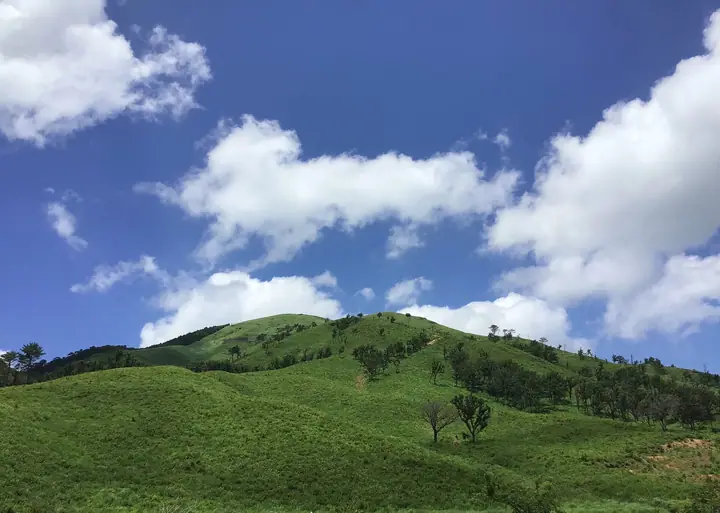
Mount Shinnyū (1,153 m) rises in Matsubara, Akiōta Town in Yamagata District, Hiroshima Prefecture, within the Nishi-Chūgoku Mountains Quasi-National Park; it is famous for its grass-clad slopes maintained for generations by mountain-burning and grazing. The summit is reached from the base trailhead in about an hour, and on clear days the 360° view extends as far as the Sea of Japan. A designated Forest-Therapy route loops around the lower slopes from the Green Shower campground and Ikoi-no-Mura Hiroshima. The peak is included in the Hundred Mountains of the Chūgoku region and Hiroshima 100.
Mount Shinnyū at a glance
- Weather: The most settled day in the next 7 days is Sun, November 8: clear, gusts up to 7 m/s. Fri, Nov 6: strong wind (gusts up to 18 m/s).
- Route: The shortest is Mount Shinnyu Out-and-Back via the East Trailhead: about 1 h 55 min, 2.6 km, about 360 m of climbing.
Mount Shinnyū weather (hourly, 14 days)
Sunrise today 06:33, sunset 17:17
| Tue, 11/3 | Wed, 11/4 | Thu, 11/5 | Fri, 11/6 | Sat, 11/7 | Sun, 11/8 | Mon, 11/9 | Tue, 11/10 | Wed, 11/11 | Thu, 11/12 | Fri, 11/13 | Sat, 11/14 | Sun, 11/15 | Mon, 11/16 | Tue, 11/17 | |||||||||||||||||||||||||||||||||||||||||||||||||||||||||||||||||||||||
|---|---|---|---|---|---|---|---|---|---|---|---|---|---|---|---|---|---|---|---|---|---|---|---|---|---|---|---|---|---|---|---|---|---|---|---|---|---|---|---|---|---|---|---|---|---|---|---|---|---|---|---|---|---|---|---|---|---|---|---|---|---|---|---|---|---|---|---|---|---|---|---|---|---|---|---|---|---|---|---|---|---|---|---|---|---|
| Japan time | 15 | 17 | 19 | 21 | 23 | 1 | 3 | 5 | 7 | 9 | 11 | 13 | 15 | 18 | 21 | 0 | 3 | 6 | 9 | 12 | 15 | 18 | 21 | 0 | 3 | 6 | 9 | 12 | 15 | 18 | 21 | 0 | 3 | 6 | 9 | 12 | 15 | 18 | 21 | 0 | 3 | 6 | 9 | 12 | 15 | 18 | 21 | 0 | 3 | 6 | 9 | 15 | 21 | 3 | 9 | 15 | 21 | 3 | 9 | 15 | 21 | 3 | 9 | 15 | 21 | 3 | 9 | 15 | 21 | 3 | 9 | 15 | 21 | 3 | 9 | 15 | 21 | 3 | 9 | 15 | 21 | 3 | 9 | 15 | |
  |   |   | | | | | | |   | | | |   |   | | | | |   | |   | | | | |   | |  | | |   | | | | | |  | | | | | | | | | | | | | | |   |   | | | | |   | | |  | | | | | | | | | | | | | | | | | | | | | | | ||
| Temperature | °C | 9° | 8° | 5° | 5° | 5° | 4° | 4° | 4° | 4° | 8° | 10° | 12° | 11° | 8° | 7° | 8° | 9° | 8° | 10° | 11° | 10° | 10° | 10° | 10° | 9° | 7° | 9° | 10° | 8° | 5° | 4° | 3° | 3° | 2° | 4° | 6° | 5° | 1° | 0° | 0° | 0° | 0° | 5° | 8° | 8° | 5° | 5° | 5° | 5° | 4° | 7° | 7° | 3° | 3° | 6° | 7° | 3° | 0° | 3° | 5° | 1° | 1° | 5° | 8° | 4° | 4° | 5° | 7° | 1° | -1° | 5° | 11° | 5° | 5° | 7° | 9° | 9° | 10° | 9° | 9° | 4° | 0° | 3° | 7° |
| Precipitation | mm | 0.2 | 0.4 | 1.8 | 3.8 | 6 | 4.0 | 0.9 | 0.7 | 0.1 | 0.2 | 1.4 | 0.3 | 0.4 | 2.0 | 0.2 | 1.3 | 0.3 | 0.2 | 0.2 | 2.3 | 12 | 27 | 1.8 | 2.8 | 2.4 | 0.8 | ||||||||||||||||||||||||||||||||||||||||||||||||||||||||||
| New snow | cm | ||||||||||||||||||||||||||||||||||||||||||||||||||||||||||||||||||||||||||||||||||||
| Snow depth | cm | 0 | 0 | 0 | 0 | 0 | 0 | 0 | 0 | 0 | 0 | 0 | 0 | 0 | 0 | 0 | 0 | 0 | 0 | 0 | 0 | 0 | 0 | 0 | 0 | 0 | 0 | 0 | 0 | 0 | 0 | 0 | 0 | 0 | 0 | 0 | 0 | 0 | 0 | 0 | 0 | 0 | 0 | 0 | 0 | 0 | 0 | 0 | 0 | 0 | 0 | 0 | 0 | 0 | 0 | 0 | 0 | 0 | 0 | 0 | 0 | 0 | 0 | 0 | 0 | 0 | 0 | 0 | 0 | 0 | 0 | 0 | 0 | 0 | 0 | 0 | 0 | 0 | 0 | 0 | 0 | 0 | 0 | 0 | 0 |
| Wind | m/s | 4 | 3 | 3 | 3 | 2 | 2 | 2 | 1 | 1 | 3 | 3 | 3 | 3 | 2 | 1 | 1 | 0 | 1 | 1 | 2 | 2 | 3 | 1 | 5 | 6 | 7 | 7 | 7 | 7 | 6 | 6 | 6 | 6 | 6 | 6 | 5 | 4 | 2 | 2 | 1 | 1 | 1 | 1 | 2 | 2 | 1 | 0 | 1 | 2 | 2 | 4 | 4 | 3 | 4 | 4 | 6 | 6 | 6 | 5 | 4 | 1 | 1 | 1 | 4 | 3 | 3 | 4 | 3 | 1 | 1 | 2 | 3 | 2 | 2 | 1 | 6 | 2 | 4 | 5 | 5 | 5 | 2 | 2 | 3 |
| Wind gusts | m/s | 12 | 10 | 8 | 7 | 7 | 5 | 5 | 4 | 4 | 7 | 9 | 8 | 8 | 7 | 5 | 4 | 4 | 3 | 4 | 6 | 6 | 9 | 8 | 11 | 14 | 16 | 16 | 18 | 17 | 16 | 15 | 16 | 16 | 16 | 14 | 14 | 12 | 10 | 5 | 5 | 3 | 3 | 4 | 6 | 7 | 6 | 2 | 2 | 4 | 6 | 9 | 10 | 10 | 9 | 10 | 16 | 16 | 16 | 15 | 11 | 10 | 4 | 4 | 11 | 10 | 9 | 9 | 10 | 8 | 3 | 6 | 9 | 8 | 6 | 7 | 16 | 15 | 12 | 12 | 13 | 12 | 11 | 6 | 8 |
| Wind dir. | ↓ | ↓ | ↓ | ↓ | ↓ | ↓ | ↓ | ↓ | ↓ | ↓ | ↓ | ↓ | ↓ | ↓ | ↓ | ↓ | ↓ | ↓ | ↓ | ↓ | ↓ | ↓ | ↓ | ↓ | ↓ | ↓ | ↓ | ↓ | ↓ | ↓ | ↓ | ↓ | ↓ | ↓ | ↓ | ↓ | ↓ | ↓ | ↓ | ↓ | ↓ | ↓ | ↓ | ↓ | ↓ | ↓ | ↓ | ↓ | ↓ | ↓ | ↓ | ↓ | ↓ | ↓ | ↓ | ↓ | ↓ | ↓ | ↓ | ↓ | ↓ | ↓ | ↓ | ↓ | ↓ | ↓ | ↓ | ↓ | ↓ | ↓ | ↓ | ↓ | ↓ | ↓ | ↓ | ↓ | ↓ | ↓ | ↓ | ↓ | ↓ | ↓ | ↓ | ↓ | |
Mount Shinnyū hiking routes
- Mount Shinnyu Out-and-Back via the East Trailhead 2.6 km · Ascent 359 m parking
- Mount Shinnyu South Trailhead Loop 4.1 km · Ascent 344 m parking
Hiking times are estimates calculated from the terrain.
Huts, campsites and lodging near Mount Shinnyū
Campsites
- 聖湖
Lodging
- いこいの村ひろしま
Lists that include Mount Shinnyū
Chugoku 100 Famous Mountains · Hiroshima Prefecture 100 Famous Mountains · Elevations of 1003 Mountains of Japan · 1000 Mountains of Japan
Mount Shinnyū facts
- Elevation
- 1,152 m
- Location
- Akiota, Hiroshima
34.649939, 132.206796 - National Park
- 西中国山地国定公園
- Website
- cs-akiota.or.jp