
Mount Odani
小谷山
Nagahama, Shiga · Elevation 495 m
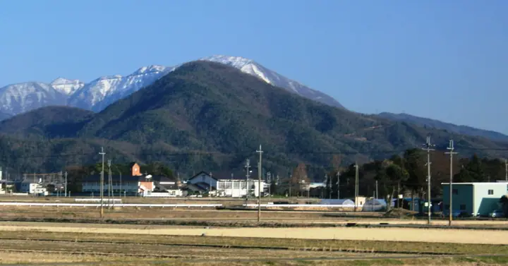
Mount Odani is a 495.1 m peak in the Kohoku district of Nagahama City, Shiga, at the western edge of the Ibuki range. The entire mountain is the nationally designated historic site of Odani Castle, the seat of three generations of the Sengoku-era Asai clan (Sukemasa, Hisamasa, and Nagamasa) and counted among Japan's three great mountain castles. A road climbs to the Bansho gate area, and the popular Ōtemichi route then crosses the bailey ruins to the secondary peak of Ōzuku and on to the top, threading the castle's stonework and enclosures. From the summit and main bailey, hikers gaze across Lake Biwa and the Kohoku plain. The peak features in Shin Hana no Hyakumeizan, Ōmi Hyakuzan, and Ōmi no Yamashiro 70.
Mount Odani at a glance
- Weather: The most settled day in the next 7 days is Wed, November 4: clear, gusts up to 5 m/s. Sat, Nov 7: strong wind (gusts up to 15 m/s).
- Route: The shortest is Odani Castle Ruins and Ōdake Castle Ruins Loop: about 2 h 53 min, 4.9 km, about 430 m of climbing.
Mount Odani weather (hourly, 14 days)
Sunrise today 06:18, sunset 16:59
| Tue, 11/3 | Wed, 11/4 | Thu, 11/5 | Fri, 11/6 | Sat, 11/7 | Sun, 11/8 | Mon, 11/9 | Tue, 11/10 | Wed, 11/11 | Thu, 11/12 | Fri, 11/13 | Sat, 11/14 | Sun, 11/15 | Mon, 11/16 | Tue, 11/17 | |||||||||||||||||||||||||||||||||||||||||||||||||||||||||||||||||||||||
|---|---|---|---|---|---|---|---|---|---|---|---|---|---|---|---|---|---|---|---|---|---|---|---|---|---|---|---|---|---|---|---|---|---|---|---|---|---|---|---|---|---|---|---|---|---|---|---|---|---|---|---|---|---|---|---|---|---|---|---|---|---|---|---|---|---|---|---|---|---|---|---|---|---|---|---|---|---|---|---|---|---|---|---|---|---|
| Japan time | 15 | 17 | 19 | 21 | 23 | 1 | 3 | 5 | 7 | 9 | 11 | 13 | 15 | 18 | 21 | 0 | 3 | 6 | 9 | 12 | 15 | 18 | 21 | 0 | 3 | 6 | 9 | 12 | 15 | 18 | 21 | 0 | 3 | 6 | 9 | 12 | 15 | 18 | 21 | 0 | 3 | 6 | 9 | 12 | 15 | 18 | 21 | 0 | 3 | 6 | 9 | 15 | 21 | 3 | 9 | 15 | 21 | 3 | 9 | 15 | 21 | 3 | 9 | 15 | 21 | 3 | 9 | 15 | 21 | 3 | 9 | 15 | 21 | 3 | 9 | 15 | 21 | 3 | 9 | 15 | 21 | 3 | 9 | 15 | |
 |  |   | | | | | |   | | | |   |   | |   | |   |   | | |   |   | | | | |   | | | | | | | | | | | | | | | | | | | | | | | | | | | | | | | | | |  | | | | | | | | | | | | | |   | | | | | | | | | ||
| Temperature | °C | 15° | 13° | 11° | 10° | 10° | 9° | 9° | 8° | 8° | 12° | 14° | 15° | 16° | 15° | 14° | 13° | 12° | 12° | 13° | 15° | 15° | 15° | 14° | 14° | 14° | 13° | 13° | 16° | 13° | 12° | 11° | 9° | 9° | 7° | 8° | 9° | 9° | 7° | 7° | 7° | 7° | 7° | 9° | 11° | 11° | 9° | 8° | 8° | 8° | 8° | 10° | 12° | 8° | 8° | 10° | 12° | 8° | 6° | 8° | 9° | 7° | 6° | 9° | 11° | 8° | 8° | 9° | 10° | 6° | 4° | 9° | 12° | 10° | 9° | 12° | 13° | 12° | 12° | 13° | 12° | 8° | 6° | 7° | 11° |
| Precipitation | mm | 3.5 | 9 | 6 | 2.3 | 0.1 | 0.2 | 3.8 | 0.4 | 0.5 | 0.9 | 0.4 | 0.5 | 0.2 | 0.4 | 0.2 | 0.6 | 0.9 | 0.8 | 0.3 | 0.2 | 0.1 | 0.2 | 0.2 | 2.4 | 2.1 | 0.2 | 0.8 | 1.3 | 0.1 | 4.3 | 8 | 0.8 | 0.7 | |||||||||||||||||||||||||||||||||||||||||||||||||||
| New snow | cm | ||||||||||||||||||||||||||||||||||||||||||||||||||||||||||||||||||||||||||||||||||||
| Snow depth | cm | 0 | 0 | 0 | 0 | 0 | 0 | 0 | 0 | 0 | 0 | 0 | 0 | 0 | 0 | 0 | 0 | 0 | 0 | 0 | 0 | 0 | 0 | 0 | 0 | 0 | 0 | 0 | 0 | 0 | 0 | 0 | 0 | 0 | 0 | 0 | 0 | 0 | 0 | 0 | 0 | 0 | 0 | 0 | 0 | 0 | 0 | 0 | 0 | 0 | 0 | 0 | 0 | 0 | 0 | 0 | 0 | 0 | 0 | 0 | 0 | 0 | 0 | 0 | 0 | 0 | 0 | 0 | 0 | 0 | 0 | 0 | 0 | 0 | 0 | 0 | 0 | 0 | 0 | 0 | 0 | 0 | 0 | 0 | 0 |
| Wind | m/s | 5 | 5 | 4 | 4 | 2 | 2 | 3 | 2 | 2 | 1 | 1 | 2 | 2 | 0 | 1 | 0 | 0 | 1 | 0 | 1 | 0 | 0 | 1 | 2 | 3 | 3 | 4 | 6 | 7 | 6 | 4 | 6 | 7 | 5 | 5 | 7 | 7 | 5 | 4 | 4 | 3 | 2 | 3 | 5 | 4 | 3 | 2 | 1 | 1 | 1 | 2 | 5 | 1 | 1 | 2 | 4 | 5 | 8 | 8 | 8 | 4 | 3 | 2 | 4 | 0 | 2 | 5 | 6 | 5 | 2 | 1 | 1 | 3 | 3 | 3 | 5 | 4 | 1 | 3 | 8 | 5 | 4 | 4 | 3 |
| Wind gusts | m/s | 10 | 10 | 9 | 8 | 7 | 4 | 6 | 6 | 5 | 4 | 4 | 5 | 5 | 4 | 3 | 4 | 6 | 3 | 3 | 3 | 4 | 2 | 2 | 4 | 6 | 7 | 9 | 13 | 14 | 13 | 11 | 13 | 13 | 14 | 13 | 15 | 14 | 14 | 10 | 8 | 7 | 7 | 7 | 10 | 10 | 9 | 6 | 4 | 3 | 3 | 5 | 10 | 9 | 3 | 6 | 10 | 10 | 16 | 18 | 17 | 15 | 8 | 7 | 9 | 9 | 5 | 10 | 13 | 12 | 10 | 5 | 5 | 6 | 6 | 7 | 8 | 9 | 9 | 6 | 15 | 15 | 10 | 10 | 8 |
| Wind dir. | ↓ | ↓ | ↓ | ↓ | ↓ | ↓ | ↓ | ↓ | ↓ | ↓ | ↓ | ↓ | ↓ | ↓ | ↓ | ↓ | ↓ | ↓ | ↓ | ↓ | ↓ | ↓ | ↓ | ↓ | ↓ | ↓ | ↓ | ↓ | ↓ | ↓ | ↓ | ↓ | ↓ | ↓ | ↓ | ↓ | ↓ | ↓ | ↓ | ↓ | ↓ | ↓ | ↓ | ↓ | ↓ | ↓ | ↓ | ↓ | ↓ | ↓ | ↓ | ↓ | ↓ | ↓ | ↓ | ↓ | ↓ | ↓ | ↓ | ↓ | ↓ | ↓ | ↓ | ↓ | ↓ | ↓ | ↓ | ↓ | ↓ | ↓ | ↓ | ↓ | ↓ | ↓ | ↓ | ↓ | ↓ | ↓ | ↓ | ↓ | ↓ | ↓ | ↓ | ||
Mount Odani hiking routes
Hiking times are estimates calculated from the terrain.
Huts, campsites and lodging near Mount Odani
Campsites
- 虎御前山キャンプ場
- 虎御前山屋外キャンプ場
Lodging
- Sugatani Onsen
Lists that include Mount Odani
Mount Odani facts
- Also known as
- 大嶽
- Elevation
- 495 m
- Location
- Nagahama, Shiga
35.465738, 136.273524 - Website
- kitabiwako.jp
- Trail Map
- www.city.nagahama.lg.jp (PDF)
- Wikipedia
- ja.wikipedia.org