
Mt. Kanakusodake
金糞岳
Nagahama, Shiga · Elevation 1,317 m
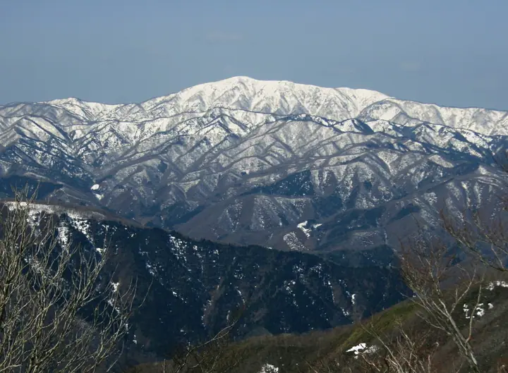
Mt. Kanakusodake is a 1,317 m peak at the southern end of the Ryōhaku Mountains in the northern Ibuki range, straddling Ibigawa in Gifu and Nagahama in Shiga. The second-highest summit in Shiga Prefecture after Mt. Ibuki, its name is thought to come from "kanakuso" — iron slag left by the area's ancient ore smelting. The summit takes in Mt. Hakusan, Mt. Ontake, the Northern Alps, and Lake Biwa below, and the peak is featured in Kansai Hyakumeizan, Kinki Hyakumeizan, Gifu Hyakuzan, Ōmi Hyakuzan, and Gifu Hyakushūzan.
Mt. Kanakusodake at a glance
- Weather: The most settled day in the next 7 days is Wed, November 4: clear, gusts up to 8 m/s. Fri, Nov 6, Sat, Nov 7: strong wind (gusts up to 18 m/s).
Mt. Kanakusodake weather (hourly, 14 days)
Sunrise today 06:18, sunset 16:59
| Tue, 11/3 | Wed, 11/4 | Thu, 11/5 | Fri, 11/6 | Sat, 11/7 | Sun, 11/8 | Mon, 11/9 | Tue, 11/10 | Wed, 11/11 | Thu, 11/12 | Fri, 11/13 | Sat, 11/14 | Sun, 11/15 | Mon, 11/16 | Tue, 11/17 | |||||||||||||||||||||||||||||||||||||||||||||||||||||||||||||||||||||||
|---|---|---|---|---|---|---|---|---|---|---|---|---|---|---|---|---|---|---|---|---|---|---|---|---|---|---|---|---|---|---|---|---|---|---|---|---|---|---|---|---|---|---|---|---|---|---|---|---|---|---|---|---|---|---|---|---|---|---|---|---|---|---|---|---|---|---|---|---|---|---|---|---|---|---|---|---|---|---|---|---|---|---|---|---|---|
| Japan time | 15 | 17 | 19 | 21 | 23 | 1 | 3 | 5 | 7 | 9 | 11 | 13 | 15 | 18 | 21 | 0 | 3 | 6 | 9 | 12 | 15 | 18 | 21 | 0 | 3 | 6 | 9 | 12 | 15 | 18 | 21 | 0 | 3 | 6 | 9 | 12 | 15 | 18 | 21 | 0 | 3 | 6 | 9 | 12 | 15 | 18 | 21 | 0 | 3 | 6 | 9 | 15 | 21 | 3 | 9 | 15 | 21 | 3 | 9 | 15 | 21 | 3 | 9 | 15 | 21 | 3 | 9 | 15 | 21 | 3 | 9 | 15 | 21 | 3 | 9 | 15 | 21 | 3 | 9 | 15 | 21 | 3 | 9 | 15 | |
 |  |   | | | | | |   | | | |   |   | |   | |   |   |   |   |   | | | | |   | | | | | | | | | | | | | |   | | | | | | | | | | | | | | | | | | | | |  | | | | | | | | | | | | | | | | | | | | | | | ||
| Temperature | °C | 11° | 7° | 5° | 5° | 4° | 3° | 3° | 3° | 3° | 10° | 13° | 13° | 12° | 9° | 9° | 8° | 8° | 8° | 10° | 13° | 13° | 10° | 10° | 10° | 9° | 9° | 9° | 12° | 8° | 6° | 5° | 4° | 3° | 2° | 3° | 4° | 4° | 2° | 1° | 1° | 1° | 1° | 4° | 6° | 6° | 3° | 2° | 2° | 2° | 3° | 7° | 8° | 2° | 2° | 6° | 7° | 3° | 0° | 3° | 4° | 1° | -1° | 5° | 6° | 2° | 3° | 4° | 5° | 0° | -3° | 7° | 9° | 4° | 4° | 7° | 8° | 8° | 8° | 9° | 8° | 2° | 0° | 4° | 6° |
| Precipitation | mm | 3.5 | 9 | 5 | 2.0 | 0.1 | 0.4 | 0.2 | 4.9 | 0.4 | 1.1 | 1.2 | 0.8 | 0.5 | 0.4 | 0.4 | 0.6 | 0.9 | 0.6 | 0.7 | 0.3 | 0.3 | 4.2 | 3.2 | 0.2 | 1.3 | 0.5 | 0.4 | 7 | 12 | 1.6 | 0.8 | 0.2 | ||||||||||||||||||||||||||||||||||||||||||||||||||||
| New snow | cm | ||||||||||||||||||||||||||||||||||||||||||||||||||||||||||||||||||||||||||||||||||||
| Snow depth | cm | 0 | 0 | 0 | 0 | 0 | 0 | 0 | 0 | 0 | 0 | 0 | 0 | 0 | 0 | 0 | 0 | 0 | 0 | 0 | 0 | 0 | 0 | 0 | 0 | 0 | 0 | 0 | 0 | 0 | 0 | 0 | 0 | 0 | 0 | 0 | 0 | 0 | 0 | 0 | 0 | 0 | 0 | 0 | 0 | 0 | 0 | 0 | 0 | 0 | 0 | 0 | 0 | 0 | 0 | 0 | 0 | 0 | 0 | 0 | 0 | 0 | 0 | 0 | 0 | 0 | 0 | 0 | 0 | 0 | 0 | 0 | 0 | 0 | 0 | 0 | 0 | 0 | 0 | 0 | 0 | 0 | 0 | 0 | 0 |
| Wind | m/s | 4 | 3 | 4 | 4 | 3 | 3 | 3 | 3 | 2 | 1 | 0 | 2 | 1 | 1 | 1 | 0 | 1 | 1 | 0 | 0 | 1 | 0 | 1 | 1 | 3 | 4 | 4 | 6 | 5 | 5 | 5 | 5 | 5 | 4 | 5 | 6 | 6 | 4 | 3 | 4 | 3 | 3 | 3 | 5 | 4 | 3 | 2 | 1 | 1 | 1 | 2 | 4 | 1 | 0 | 2 | 4 | 4 | 7 | 7 | 6 | 4 | 3 | 3 | 4 | 1 | 2 | 5 | 5 | 4 | 2 | 2 | 2 | 2 | 2 | 3 | 3 | 2 | 0 | 4 | 7 | 5 | 4 | 2 | 2 |
| Wind gusts | m/s | 10 | 10 | 10 | 11 | 11 | 9 | 9 | 10 | 8 | 6 | 4 | 6 | 6 | 4 | 6 | 6 | 7 | 6 | 3 | 3 | 4 | 3 | 4 | 5 | 8 | 12 | 13 | 17 | 17 | 16 | 15 | 15 | 15 | 16 | 15 | 18 | 18 | 17 | 12 | 11 | 11 | 11 | 10 | 13 | 13 | 10 | 7 | 5 | 5 | 6 | 7 | 12 | 10 | 4 | 7 | 12 | 14 | 20 | 21 | 21 | 17 | 11 | 9 | 10 | 10 | 8 | 14 | 16 | 15 | 12 | 6 | 8 | 7 | 6 | 7 | 11 | 9 | 8 | 12 | 18 | 18 | 14 | 12 | 7 |
| Wind dir. | ↓ | ↓ | ↓ | ↓ | ↓ | ↓ | ↓ | ↓ | ↓ | ↓ | ↓ | ↓ | ↓ | ↓ | ↓ | ↓ | ↓ | ↓ | ↓ | ↓ | ↓ | ↓ | ↓ | ↓ | ↓ | ↓ | ↓ | ↓ | ↓ | ↓ | ↓ | ↓ | ↓ | ↓ | ↓ | ↓ | ↓ | ↓ | ↓ | ↓ | ↓ | ↓ | ↓ | ↓ | ↓ | ↓ | ↓ | ↓ | ↓ | ↓ | ↓ | ↓ | ↓ | ↓ | ↓ | ↓ | ↓ | ↓ | ↓ | ↓ | ↓ | ↓ | ↓ | ↓ | ↓ | ↓ | ↓ | ↓ | ↓ | ↓ | ↓ | ↓ | ↓ | ↓ | ↓ | ↓ | ↓ | ↓ | ↓ | ↓ | ↓ | ↓ | ↓ | ↓ | |
Lists that include Mt. Kanakusodake
Kansai 100 Famous Mountains · Kinki 100 Famous Mountains · 100 Mountains of Gifu · Omi 100 Mountains · Elevations of 1003 Mountains of Japan · 1000 Mountains of Japan
Mt. Kanakusodake facts
- Elevation
- 1,317 m
- Location
- Nagahama, Shiga
35.550188, 136.337167 - Website
- kitabiwako.jp
- Trail Map
- www.city.nagahama.lg.jp
- Wikipedia
- ja.wikipedia.org