
Mount Nekodake Eastern Peak
根子岳東峰
阿蘇山 レベル2(火口周辺規制) · issued September 1 at 16:00
Aso, Kumamoto / Takamori, Kumamoto · Elevation 1,408 m
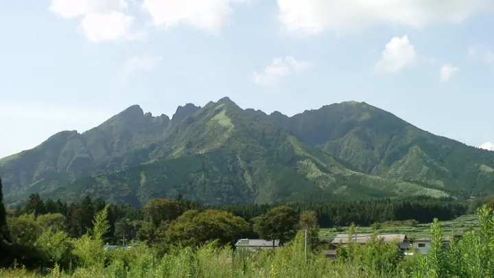
Mount Nekodake Eastern Peak is a 1,408 m summit on the border of Aso City and Takamori Town, Kumamoto Prefecture, within the jagged mountains of eastern Aso. Routes toward the highest summit, Tengu-mine (1,433 m), and the west peak are impassable because of collapse, making the eastern peak with its triangulation point the hiking objective. It lies in Aso-Kuju National Park and is admired for Miyama-kirishima azaleas in early summer and autumn foliage.
Mount Nekodake Eastern Peak at a glance
- Weather: The most settled day in the next 7 days is Mon, November 9: cloudy, gusts up to 6 m/s.
- Route: The shortest is Nekodake East Peak via the Oto Ridge: about 3 h 5 min, 4.5 km, about 630 m of climbing.
Mount Nekodake Eastern Peak weather (hourly, 14 days)
Sunrise today 06:34, sunset 17:24
| Tue, 11/3 | Wed, 11/4 | Thu, 11/5 | Fri, 11/6 | Sat, 11/7 | Sun, 11/8 | Mon, 11/9 | Tue, 11/10 | Wed, 11/11 | Thu, 11/12 | Fri, 11/13 | Sat, 11/14 | Sun, 11/15 | Mon, 11/16 | Tue, 11/17 | |||||||||||||||||||||||||||||||||||||||||||||||||||||||||||||||||||||||
|---|---|---|---|---|---|---|---|---|---|---|---|---|---|---|---|---|---|---|---|---|---|---|---|---|---|---|---|---|---|---|---|---|---|---|---|---|---|---|---|---|---|---|---|---|---|---|---|---|---|---|---|---|---|---|---|---|---|---|---|---|---|---|---|---|---|---|---|---|---|---|---|---|---|---|---|---|---|---|---|---|---|---|---|---|---|
| Japan time | 21 | 23 | 1 | 3 | 5 | 7 | 9 | 11 | 13 | 15 | 17 | 19 | 21 | 0 | 3 | 6 | 9 | 12 | 15 | 18 | 21 | 0 | 3 | 6 | 9 | 12 | 15 | 18 | 21 | 0 | 3 | 6 | 9 | 12 | 15 | 18 | 21 | 0 | 3 | 6 | 9 | 12 | 15 | 18 | 21 | 0 | 3 | 6 | 9 | 12 | 15 | 21 | 3 | 9 | 15 | 21 | 3 | 9 | 15 | 21 | 3 | 9 | 15 | 21 | 3 | 9 | 15 | 21 | 3 | 9 | 15 | 21 | 3 | 9 | 15 | 21 | 3 | 9 | 15 | 21 | 3 | 9 | 15 | 21 | |
  |   | |   | |   | | | | | | | |   | | |   |   | | | | |   |  |   |   | | | | | | |  | | | | | | | | | | | | | | | | | |   |   | | | | | | | | | | | |  | | | | | | | | | | | | | | | |  | | | | | ||
| Temperature | °C | 5° | 5° | 5° | 5° | 5° | 5° | 7° | 10° | 12° | 12° | 10° | 8° | 8° | 8° | 7° | 8° | 10° | 14° | 12° | 12° | 11° | 9° | 7° | 6° | 8° | 11° | 10° | 5° | 3° | 1° | -1° | -3° | 2° | 6° | 7° | 2° | -1° | -2° | -3° | -2° | 5° | 9° | 8° | 5° | 3° | 2° | 4° | 5° | 8° | 9° | 7° | 2° | 1° | 4° | 8° | 0° | 0° | 3° | 6° | -1° | -3° | 3° | 8° | 0° | -3° | 5° | 10° | 2° | 2° | 5° | 12° | 5° | 6° | 10° | 11° | 7° | 9° | 9° | 12° | 3° | 4° | 5° | 11° | 2° |
| Precipitation | mm | 1.0 | 0.3 | 0.5 | 1.0 | 3.4 | 3.2 | 1.3 | 0.1 | 0.3 | 0.9 | 4.0 | 4.5 | 0.1 | 0.3 | ||||||||||||||||||||||||||||||||||||||||||||||||||||||||||||||||||||||
| New snow | cm | ||||||||||||||||||||||||||||||||||||||||||||||||||||||||||||||||||||||||||||||||||||
| Snow depth | cm | 0 | 0 | 0 | 0 | 0 | 0 | 0 | 0 | 0 | 0 | 0 | 0 | 0 | 0 | 0 | 0 | 0 | 0 | 0 | 0 | 0 | 0 | 0 | 0 | 0 | 0 | 0 | 0 | 0 | 0 | 0 | 0 | 0 | 0 | 0 | 0 | 0 | 0 | 0 | 0 | 0 | 0 | 0 | 0 | 0 | 0 | 0 | 0 | 0 | 0 | 0 | 0 | 0 | 0 | 0 | 0 | 0 | 0 | 0 | 0 | 0 | 0 | 0 | 0 | 0 | 0 | 0 | 0 | 0 | 0 | 0 | 0 | 0 | 0 | 0 | 0 | 0 | 0 | 0 | 0 | 0 | 0 | 0 | 0 |
| Wind | m/s | 1 | 1 | 2 | 2 | 2 | 2 | 3 | 3 | 3 | 3 | 2 | 1 | 2 | 1 | 1 | 0 | 1 | 3 | 5 | 5 | 5 | 4 | 5 | 4 | 5 | 5 | 5 | 3 | 3 | 3 | 3 | 2 | 3 | 3 | 3 | 1 | 1 | 1 | 1 | 2 | 2 | 1 | 1 | 1 | 1 | 0 | 1 | 1 | 1 | 2 | 2 | 1 | 1 | 3 | 4 | 2 | 2 | 3 | 3 | 1 | 0 | 0 | 2 | 1 | 1 | 1 | 3 | 2 | 1 | 1 | 3 | 1 | 2 | 5 | 2 | 1 | 2 | 3 | 3 | 1 | 2 | 2 | 1 | 1 |
| Wind gusts | m/s | 4 | 5 | 7 | 6 | 6 | 6 | 8 | 8 | 8 | 9 | 8 | 5 | 4 | 5 | 3 | 3 | 4 | 8 | 14 | 14 | 14 | 13 | 13 | 13 | 12 | 14 | 14 | 12 | 10 | 10 | 9 | 8 | 9 | 10 | 10 | 8 | 4 | 4 | 4 | 5 | 6 | 7 | 5 | 4 | 3 | 3 | 4 | 4 | 4 | 6 | 6 | 7 | 4 | 8 | 11 | 11 | 7 | 9 | 9 | 8 | 2 | 3 | 7 | 7 | 3 | 5 | 8 | 8 | 5 | 4 | 8 | 8 | 7 | 14 | 14 | 6 | 6 | 9 | 10 | 8 | 6 | 6 | 7 | 7 |
| Wind dir. | ↓ | ↓ | ↓ | ↓ | ↓ | ↓ | ↓ | ↓ | ↓ | ↓ | ↓ | ↓ | ↓ | ↓ | ↓ | ↓ | ↓ | ↓ | ↓ | ↓ | ↓ | ↓ | ↓ | ↓ | ↓ | ↓ | ↓ | ↓ | ↓ | ↓ | ↓ | ↓ | ↓ | ↓ | ↓ | ↓ | ↓ | ↓ | ↓ | ↓ | ↓ | ↓ | ↓ | ↓ | ↓ | ↓ | ↓ | ↓ | ↓ | ↓ | ↓ | ↓ | ↓ | ↓ | ↓ | ↓ | ↓ | ↓ | ↓ | ↓ | ↓ | ↓ | ↓ | ↓ | ↓ | ↓ | ↓ | ↓ | ↓ | ↓ | ↓ | ↓ | ↓ | ↓ | ↓ | ↓ | ↓ | ↓ | ↓ | ↓ | ↓ | ↓ | ↓ | ↓ | |
Mount Nekodake Eastern Peak live cameras
Mount Nekodake Eastern Peak hiking routes
- Nekodake East Peak via the Oto Ridge 4.5 km · Ascent 630 m parking
- Mount Neko East Peak Return via the Hakoishi-Tsurii Ridge 5.3 km · Ascent 640 m parking
Hiking times are estimates calculated from the terrain.
Huts, campsites and lodging near Mount Nekodake Eastern Peak
Mountain huts
Campsites
- 鍋の平キャンプ場
- J.club
Lodging
- Pension Yamarinsha
- Coffee pension
- B&B Flower Garden
- Pension cream house
Lists that include Mount Nekodake Eastern Peak
Mount Nekodake Eastern Peak facts
- Elevation
- 1,408 m
- Location
- Aso, Kumamoto / Takamori, Kumamoto
32.885340, 131.150676 - National Park
- 阿蘇くじゅう国立公園
- Volcano
- Active volcano (阿蘇山)
- Website
- asotakamori-kanko.com
- Trail Map
- aso-visitorcenter.com (PDF)
- Access Information
- aso-visitorcenter.com
- Wikipedia
- ja.wikipedia.org