
Mount Aso
高岳
阿蘇山 レベル2(火口周辺規制) · issued September 1 at 16:00
Takamori, Kumamoto / Aso, Kumamoto · Elevation 1,592 m
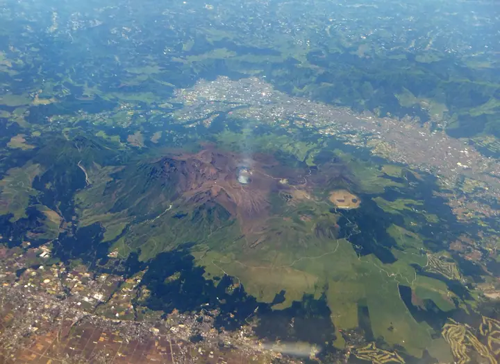
Mount Aso is an active volcano extending across Aso City, Minamiaso Village and surrounding areas of Kumamoto Prefecture, with central cones inside one of the world’s largest calderas, measuring 25 km north–south and 17 km east–west. Its peaks include Takadake, Nakadake, Nekodake, Eboshidake and Kishimadake; the highest, Takadake (1,592.3 m), stands on the boundary between Aso City and Takamori Town. Nakadake’s First Crater continues to emit volcanic gases, and access restrictions vary with volcanic activity levels. The volcano forms the heart of Aso-Kuju National Park.
Mount Aso at a glance
- Weather: The most settled day in the next 7 days is Sat, November 7: clear, gusts up to 10 m/s.
- Route: The shortest is Mount Aso: Takadake via Minamidake and Nakadake from Sunasenri: about 4 h 19 min, 7.6 km, about 490 m of climbing.
Mount Aso weather (hourly, 14 days)
Sunrise today 06:34, sunset 17:24
| Tue, 11/3 | Wed, 11/4 | Thu, 11/5 | Fri, 11/6 | Sat, 11/7 | Sun, 11/8 | Mon, 11/9 | Tue, 11/10 | Wed, 11/11 | Thu, 11/12 | Fri, 11/13 | Sat, 11/14 | Sun, 11/15 | Mon, 11/16 | Tue, 11/17 | |||||||||||||||||||||||||||||||||||||||||||||||||||||||||||||||||||||||
|---|---|---|---|---|---|---|---|---|---|---|---|---|---|---|---|---|---|---|---|---|---|---|---|---|---|---|---|---|---|---|---|---|---|---|---|---|---|---|---|---|---|---|---|---|---|---|---|---|---|---|---|---|---|---|---|---|---|---|---|---|---|---|---|---|---|---|---|---|---|---|---|---|---|---|---|---|---|---|---|---|---|---|---|---|---|
| Japan time | 15 | 17 | 19 | 21 | 23 | 1 | 3 | 5 | 7 | 9 | 11 | 13 | 15 | 18 | 21 | 0 | 3 | 6 | 9 | 12 | 15 | 18 | 21 | 0 | 3 | 6 | 9 | 12 | 15 | 18 | 21 | 0 | 3 | 6 | 9 | 12 | 15 | 18 | 21 | 0 | 3 | 6 | 9 | 12 | 15 | 18 | 21 | 0 | 3 | 6 | 9 | 15 | 21 | 3 | 9 | 15 | 21 | 3 | 9 | 15 | 21 | 3 | 9 | 15 | 21 | 3 | 9 | 15 | 21 | 3 | 9 | 15 | 21 | 3 | 9 | 15 | 21 | 3 | 9 | 15 | 21 | 3 | 9 | 15 | |
  |   |   |   | | | | |   | | | | |   |   | | |   |  |   | | | | | | | | | |  | | | | | | | | | | | | | | | | | | | | | | |   | | | | | | | | | | | |  | | | | | | | | | | | | | |   | |  | | | | ||
| Temperature | °C | 10° | 7° | 5° | 4° | 3° | 3° | 4° | 2° | 4° | 6° | 9° | 12° | 12° | 8° | 7° | 6° | 6° | 6° | 9° | 13° | 12° | 11° | 11° | 9° | 8° | 6° | 7° | 10° | 9° | 3° | 1° | 0° | -2° | -3° | 1° | 5° | 6° | 1° | -2° | -3° | -4° | -3° | 4° | 8° | 8° | 5° | 3° | 2° | 3° | 3° | 5° | 9° | 0° | 0° | 3° | 7° | -1° | -1° | 1° | 5° | -3° | -4° | 2° | 7° | -2° | -4° | 3° | 8° | 1° | 1° | 3° | 11° | 3° | 5° | 9° | 10° | 6° | 8° | 8° | 11° | 2° | 3° | 4° | 10° |
| Precipitation | mm | 0.2 | 0.1 | 0.6 | 0.9 | 0.9 | 2.7 | 1.4 | 0.6 | 0.2 | 4.0 | 4.5 | 0.1 | 0.3 | |||||||||||||||||||||||||||||||||||||||||||||||||||||||||||||||||||||||
| New snow | cm | ||||||||||||||||||||||||||||||||||||||||||||||||||||||||||||||||||||||||||||||||||||
| Snow depth | cm | 0 | 0 | 0 | 0 | 0 | 0 | 0 | 0 | 0 | 0 | 0 | 0 | 0 | 0 | 0 | 0 | 0 | 0 | 0 | 0 | 0 | 0 | 0 | 0 | 0 | 0 | 0 | 0 | 0 | 0 | 0 | 0 | 0 | 0 | 0 | 0 | 0 | 0 | 0 | 0 | 0 | 0 | 0 | 0 | 0 | 0 | 0 | 0 | 0 | 0 | 0 | 0 | 0 | 0 | 0 | 0 | 0 | 0 | 0 | 0 | 0 | 0 | 0 | 0 | 0 | 0 | 0 | 0 | 0 | 0 | 0 | 0 | 0 | 0 | 0 | 0 | 0 | 0 | 0 | 0 | 0 | 0 | 0 | 0 |
| Wind | m/s | 3 | 2 | 1 | 1 | 1 | 2 | 2 | 2 | 2 | 3 | 3 | 3 | 3 | 1 | 2 | 0 | 1 | 1 | 1 | 2 | 4 | 3 | 3 | 4 | 4 | 3 | 4 | 5 | 5 | 3 | 3 | 4 | 3 | 2 | 3 | 3 | 3 | 1 | 1 | 1 | 1 | 1 | 1 | 1 | 0 | 1 | 1 | 0 | 1 | 1 | 1 | 3 | 1 | 1 | 3 | 4 | 2 | 2 | 3 | 3 | 1 | 0 | 0 | 2 | 1 | 1 | 1 | 3 | 2 | 1 | 1 | 3 | 1 | 2 | 5 | 2 | 1 | 2 | 3 | 3 | 1 | 2 | 2 | 1 |
| Wind gusts | m/s | 7 | 7 | 5 | 4 | 4 | 6 | 6 | 6 | 6 | 8 | 9 | 9 | 9 | 9 | 6 | 5 | 4 | 2 | 4 | 8 | 11 | 12 | 10 | 11 | 11 | 11 | 11 | 14 | 14 | 13 | 10 | 11 | 11 | 9 | 9 | 10 | 10 | 8 | 4 | 3 | 3 | 3 | 5 | 5 | 5 | 4 | 3 | 3 | 4 | 4 | 4 | 9 | 7 | 4 | 8 | 11 | 11 | 7 | 9 | 9 | 8 | 2 | 3 | 7 | 7 | 3 | 5 | 8 | 8 | 5 | 4 | 8 | 8 | 7 | 14 | 14 | 6 | 6 | 9 | 10 | 8 | 6 | 6 | 7 |
| Wind dir. | ↓ | ↓ | ↓ | ↓ | ↓ | ↓ | ↓ | ↓ | ↓ | ↓ | ↓ | ↓ | ↓ | ↓ | ↓ | ↓ | ↓ | ↓ | ↓ | ↓ | ↓ | ↓ | ↓ | ↓ | ↓ | ↓ | ↓ | ↓ | ↓ | ↓ | ↓ | ↓ | ↓ | ↓ | ↓ | ↓ | ↓ | ↓ | ↓ | ↓ | ↓ | ↓ | ↓ | ↓ | ↓ | ↓ | ↓ | ↓ | ↓ | ↓ | ↓ | ↓ | ↓ | ↓ | ↓ | ↓ | ↓ | ↓ | ↓ | ↓ | ↓ | ↓ | ↓ | ↓ | ↓ | ↓ | ↓ | ↓ | ↓ | ↓ | ↓ | ↓ | ↓ | ↓ | ↓ | ↓ | ↓ | ↓ | ↓ | ↓ | ↓ | ↓ | ↓ | ↓ | |
Mount Aso live cameras
Mount Aso hiking routes
- Mount Aso: Takadake via Minamidake and Nakadake from Sunasenri 7.6 km · Ascent 492 m parking
- Mount Takadake–Nakadake Circuit from Sensuikyo via Sensui Ridge 6.6 km · Ascent 737 m parking
- Mount Takadake, Mount Nakadake and Tsukimi Hut Loop from Sensui Gorge 7.3 km · Ascent 828 m parking
- Mount Takadake, Nakadake and Minamidake Return via Sunasenri Boardwalk 9.8 km · Ascent 578 m Aso Sanjo Terminal (Bus station), 阿蘇山上駐車場 (parking)
- Mount Nakadake and Mount Takadake Round Trip from Sensuikyo 8.6 km · Ascent 758 m parking
- Mount Minami, Mount Naka and Mount Taka Return from Aso Sanjo 9.9 km · Ascent 664 m 阿蘇山上駐車場, Aso Sanjo Terminal (Bus station) (parking)
- Mount Aso Nakadake–Takadake via Sunasenri 11.2 km · Ascent 630 m 阿蘇山上駐車場, Aso Sanjo Terminal (Bus station) (parking)
Hiking times are estimates calculated from the terrain.
Huts, campsites and lodging near Mount Aso
Mountain huts
Campsites
- 鍋の平キャンプ場
Lodging
- かんぽの宿
Lists that include Mount Aso
100 Famous Japanese Mountains · Japan 200 Famous Mountains · Japan's 300 Famous Mountains · New 100 Famous Flower Mountains · New Japan 100 Famous Mountains · Illustrated Collection of Japan's Famous Mountains · Kyushu 100 Famous Mountains · Kumamoto 100 Famous Mountains · Aso 5 Peaks · Elevations of 1003 Mountains of Japan · 1000 Mountains of Japan
Mount Aso facts
- Also known as
- 阿蘇五岳 · Aso-san
- Elevation
- 1,592 m
- Location
- Takamori, Kumamoto / Aso, Kumamoto
32.884367, 131.103909 - National Park
- 阿蘇くじゅう国立公園
- Volcano
- Active volcano (阿蘇山)
- Website
- www.city.aso.kumamoto.jp
- Trail Map
- aso-visitorcenter.com (PDF)
- Access Information
- aso-visitorcenter.com
- Wikipedia
- ja.wikipedia.org