
Mount Neko
根子岳
阿蘇山 レベル2(火口周辺規制) · issued September 1 at 16:00
Aso, Kumamoto / Takamori, Kumamoto · Elevation 1,433 m
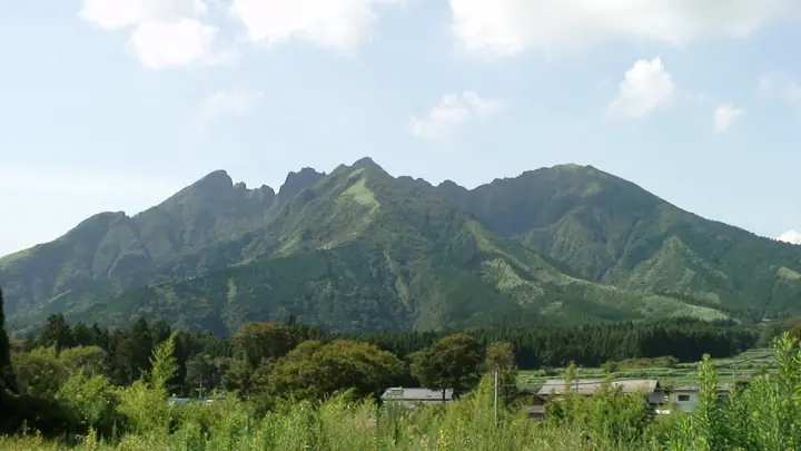
Mount Neko is a 1,433 m peak on the boundary between Aso City and Takamori Town in Kumamoto Prefecture, within Aso-Kuju National Park. Its serrated ridge resembles cat ears, giving it the nickname “Cat Peak,” and it is a symbol of Takamori. Older than Aso’s other central volcanic cones, it has a rugged summit area requiring rock-climbing skills. The Oodo-One route from the Kamishikimi side, formerly used by beginners, has been impassable along with the Maehara pasture route since July 2023.
Mount Neko at a glance
- Weather: The most settled day in the next 7 days is Sat, November 7: clear, gusts up to 10 m/s.
- Route: The shortest is Nekodake East Peak via the Oto Ridge: about 3 h 5 min, 4.5 km, about 630 m of climbing.
Mount Neko weather (hourly, 14 days)
Sunrise today 06:34, sunset 17:24
| Tue, 11/3 | Wed, 11/4 | Thu, 11/5 | Fri, 11/6 | Sat, 11/7 | Sun, 11/8 | Mon, 11/9 | Tue, 11/10 | Wed, 11/11 | Thu, 11/12 | Fri, 11/13 | Sat, 11/14 | Sun, 11/15 | Mon, 11/16 | Tue, 11/17 | |||||||||||||||||||||||||||||||||||||||||||||||||||||||||||||||||||||||
|---|---|---|---|---|---|---|---|---|---|---|---|---|---|---|---|---|---|---|---|---|---|---|---|---|---|---|---|---|---|---|---|---|---|---|---|---|---|---|---|---|---|---|---|---|---|---|---|---|---|---|---|---|---|---|---|---|---|---|---|---|---|---|---|---|---|---|---|---|---|---|---|---|---|---|---|---|---|---|---|---|---|---|---|---|---|
| Japan time | 15 | 17 | 19 | 21 | 23 | 1 | 3 | 5 | 7 | 9 | 11 | 13 | 15 | 18 | 21 | 0 | 3 | 6 | 9 | 12 | 15 | 18 | 21 | 0 | 3 | 6 | 9 | 12 | 15 | 18 | 21 | 0 | 3 | 6 | 9 | 12 | 15 | 18 | 21 | 0 | 3 | 6 | 9 | 12 | 15 | 18 | 21 | 0 | 3 | 6 | 9 | 15 | 21 | 3 | 9 | 15 | 21 | 3 | 9 | 15 | 21 | 3 | 9 | 15 | 21 | 3 | 9 | 15 | 21 | 3 | 9 | 15 | 21 | 3 | 9 | 15 | 21 | 3 | 9 | 15 | 21 | 3 | 9 | 15 | |
  |   |   |   | | | | |   | | | | |   |   | | |   |  |   | | | | | | | | | |  | | | | | | | | | | | | | | | | | | | | | | |   | | | | | | | | | | | |  | | | | | | | | | | | | | |   | |  | | | | ||
| Temperature | °C | 11° | 8° | 6° | 5° | 4° | 4° | 5° | 4° | 5° | 7° | 11° | 13° | 13° | 9° | 8° | 7° | 7° | 7° | 10° | 14° | 13° | 12° | 12° | 11° | 9° | 7° | 8° | 11° | 10° | 4° | 2° | 1° | -1° | -2° | 2° | 6° | 7° | 2° | -1° | -2° | -2° | -2° | 5° | 9° | 9° | 6° | 4° | 3° | 4° | 4° | 6° | 10° | 1° | 1° | 4° | 8° | 0° | 0° | 2° | 6° | -1° | -3° | 3° | 8° | -1° | -3° | 5° | 9° | 2° | 2° | 4° | 12° | 4° | 6° | 10° | 11° | 7° | 9° | 9° | 12° | 3° | 4° | 5° | 11° |
| Precipitation | mm | 0.2 | 0.1 | 0.6 | 0.9 | 0.9 | 2.7 | 1.4 | 0.6 | 0.2 | 4.0 | 4.5 | 0.1 | 0.3 | |||||||||||||||||||||||||||||||||||||||||||||||||||||||||||||||||||||||
| New snow | cm | ||||||||||||||||||||||||||||||||||||||||||||||||||||||||||||||||||||||||||||||||||||
| Snow depth | cm | 0 | 0 | 0 | 0 | 0 | 0 | 0 | 0 | 0 | 0 | 0 | 0 | 0 | 0 | 0 | 0 | 0 | 0 | 0 | 0 | 0 | 0 | 0 | 0 | 0 | 0 | 0 | 0 | 0 | 0 | 0 | 0 | 0 | 0 | 0 | 0 | 0 | 0 | 0 | 0 | 0 | 0 | 0 | 0 | 0 | 0 | 0 | 0 | 0 | 0 | 0 | 0 | 0 | 0 | 0 | 0 | 0 | 0 | 0 | 0 | 0 | 0 | 0 | 0 | 0 | 0 | 0 | 0 | 0 | 0 | 0 | 0 | 0 | 0 | 0 | 0 | 0 | 0 | 0 | 0 | 0 | 0 | 0 | 0 |
| Wind | m/s | 3 | 2 | 1 | 1 | 1 | 2 | 2 | 2 | 2 | 3 | 3 | 3 | 3 | 1 | 2 | 0 | 1 | 1 | 1 | 2 | 4 | 3 | 3 | 4 | 4 | 3 | 4 | 5 | 5 | 3 | 3 | 4 | 3 | 2 | 3 | 3 | 3 | 1 | 1 | 1 | 1 | 1 | 1 | 1 | 0 | 1 | 1 | 0 | 1 | 1 | 1 | 3 | 1 | 1 | 3 | 4 | 2 | 2 | 3 | 3 | 1 | 0 | 0 | 2 | 1 | 1 | 1 | 3 | 2 | 1 | 1 | 3 | 1 | 2 | 5 | 2 | 1 | 2 | 3 | 3 | 1 | 2 | 2 | 1 |
| Wind gusts | m/s | 7 | 7 | 5 | 4 | 4 | 6 | 6 | 6 | 6 | 8 | 9 | 9 | 9 | 9 | 6 | 5 | 4 | 2 | 4 | 8 | 11 | 12 | 10 | 11 | 11 | 11 | 11 | 14 | 14 | 13 | 10 | 11 | 11 | 9 | 9 | 10 | 10 | 8 | 4 | 3 | 3 | 3 | 5 | 5 | 5 | 4 | 3 | 3 | 4 | 4 | 4 | 9 | 7 | 4 | 8 | 11 | 11 | 7 | 9 | 9 | 8 | 2 | 3 | 7 | 7 | 3 | 5 | 8 | 8 | 5 | 4 | 8 | 8 | 7 | 14 | 14 | 6 | 6 | 9 | 10 | 8 | 6 | 6 | 7 |
| Wind dir. | ↓ | ↓ | ↓ | ↓ | ↓ | ↓ | ↓ | ↓ | ↓ | ↓ | ↓ | ↓ | ↓ | ↓ | ↓ | ↓ | ↓ | ↓ | ↓ | ↓ | ↓ | ↓ | ↓ | ↓ | ↓ | ↓ | ↓ | ↓ | ↓ | ↓ | ↓ | ↓ | ↓ | ↓ | ↓ | ↓ | ↓ | ↓ | ↓ | ↓ | ↓ | ↓ | ↓ | ↓ | ↓ | ↓ | ↓ | ↓ | ↓ | ↓ | ↓ | ↓ | ↓ | ↓ | ↓ | ↓ | ↓ | ↓ | ↓ | ↓ | ↓ | ↓ | ↓ | ↓ | ↓ | ↓ | ↓ | ↓ | ↓ | ↓ | ↓ | ↓ | ↓ | ↓ | ↓ | ↓ | ↓ | ↓ | ↓ | ↓ | ↓ | ↓ | ↓ | ↓ | |
Mount Neko live cameras
Mount Neko hiking routes
- Nekodake East Peak via the Oto Ridge 4.5 km · Ascent 630 m parking
- Mount Neko East Peak Return via the Hakoishi-Tsurii Ridge 5.3 km · Ascent 640 m parking
Hiking times are estimates calculated from the terrain.
Huts, campsites and lodging near Mount Neko
Mountain huts
Campsites
- 鍋の平キャンプ場
- J.club
Lodging
- Pension Yamarinsha
- Coffee pension
- B&B Flower Garden
- Pension cream house
Lists that include Mount Neko
Kyushu 100 Famous Mountains · Elevations of 1003 Mountains of Japan · 1000 Mountains of Japan
Mount Neko facts
- Also known as
- 猫岳 · Nekodake
- Elevation
- 1,433 m
- Location
- Aso, Kumamoto / Takamori, Kumamoto
32.883948, 131.144593 - National Park
- 阿蘇くじゅう国立公園
- Volcano
- Active volcano (阿蘇山)
- Website
- asotakamori-kanko.com
- Trail Map
- aso-visitorcenter.com (PDF)