
Mount Mitsumineyama
三峰山
Minakami, Gunma / Numata, Gunma · Elevation 1,122 m
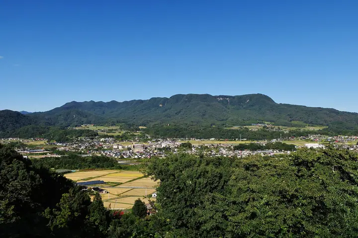
Mitsumineyama (also called Jōshū Mitsumineyama) is a 1,122 m peak straddling Numata and Minakami in Gunma Prefecture, distinguished by a flat-topped silhouette formed by three named summits — Gokanmine, Fukikaeshimine and Oibamine — aligned from north to south. Listed in both the Kantō 100 Mountains and the Gunma 100 Mountains, it is most often climbed from the Numata side via Kawachi Shrine, with sweeping views from the summit toward Tanigawadake and the Jōshin'etsu peaks.
Mount Mitsumineyama at a glance
- Weather: The most settled day in the next 7 days is Wed, November 4: clear, gusts up to 8 m/s. Sat, Nov 7: strong wind (gusts up to 15 m/s).
Mount Mitsumineyama weather (hourly, 14 days)
Sunrise today 06:09, sunset 16:46
| Tue, 11/3 | Wed, 11/4 | Thu, 11/5 | Fri, 11/6 | Sat, 11/7 | Sun, 11/8 | Mon, 11/9 | Tue, 11/10 | Wed, 11/11 | Thu, 11/12 | Fri, 11/13 | Sat, 11/14 | Sun, 11/15 | Mon, 11/16 | Tue, 11/17 | |||||||||||||||||||||||||||||||||||||||||||||||||||||||||||||||||||||||
|---|---|---|---|---|---|---|---|---|---|---|---|---|---|---|---|---|---|---|---|---|---|---|---|---|---|---|---|---|---|---|---|---|---|---|---|---|---|---|---|---|---|---|---|---|---|---|---|---|---|---|---|---|---|---|---|---|---|---|---|---|---|---|---|---|---|---|---|---|---|---|---|---|---|---|---|---|---|---|---|---|---|---|---|---|---|
| Japan time | 15 | 17 | 19 | 21 | 23 | 1 | 3 | 5 | 7 | 9 | 11 | 13 | 15 | 18 | 21 | 0 | 3 | 6 | 9 | 12 | 15 | 18 | 21 | 0 | 3 | 6 | 9 | 12 | 15 | 18 | 21 | 0 | 3 | 6 | 9 | 12 | 15 | 18 | 21 | 0 | 3 | 6 | 9 | 12 | 15 | 18 | 21 | 0 | 3 | 6 | 9 | 15 | 21 | 3 | 9 | 15 | 21 | 3 | 9 | 15 | 21 | 3 | 9 | 15 | 21 | 3 | 9 | 15 | 21 | 3 | 9 | 15 | 21 | 3 | 9 | 15 | 21 | 3 | 9 | 15 | 21 | 3 | 9 | 15 | |
  |   |  | | | | | |  |   | | | |   |   | | | |   | | |   | |  | | | | | | | | | | |   | |   |   |   | | | | | | | | | | | | | | | |   | | |   |   | | | | | | | | | |   | | | |  | | | | |   | | | | | | | ||
| Temperature | °C | 9° | 5° | 3° | 2° | 1° | 0° | 0° | 0° | 2° | 9° | 11° | 12° | 10° | 7° | 6° | 5° | 6° | 6° | 9° | 13° | 12° | 9° | 8° | 8° | 6° | 8° | 13° | 15° | 13° | 10° | 8° | 6° | 5° | 4° | 4° | 5° | 3° | 2° | 2° | 2° | 2° | 2° | 4° | 6° | 5° | 2° | 1° | 1° | 2° | 2° | 6° | 7° | 4° | 3° | 5° | 6° | 4° | 2° | 2° | 2° | 2° | 2° | 4° | 6° | 1° | 0° | 4° | 3° | 2° | 0° | 5° | 8° | 0° | -1° | 7° | 10° | 5° | 6° | 12° | 8° | 2° | 0° | 4° | 8° |
| Precipitation | mm | 0.2 | 0.5 | 9 | 8 | 1.2 | 0.6 | 0.3 | 0.1 | 0.5 | 0.5 | 0.5 | 0.3 | 0.2 | 0.2 | 0.1 | 0.2 | 0.3 | 0.2 | 2.1 | 2.1 | 6 | 1.9 | 0.3 | 3.2 | 1.1 | 0.3 | 3.6 | 6 | 1.0 | 6 | 0.9 | |||||||||||||||||||||||||||||||||||||||||||||||||||||
| New snow | cm | <.1 | <.1 | <.1 | <.1 | <.1 | <.1 | 0.2 | 0.8 | 1.0 | <.1 | 0.2 | 0.1 | <.1 | <.1 | 0.1 | 0.2 | ||||||||||||||||||||||||||||||||||||||||||||||||||||||||||||||||||||
| Snow depth | cm | 0 | 0 | 0 | 0 | 0 | 0 | 0 | 0 | 0 | 0 | 0 | 0 | 0 | 0 | 0 | 0 | 0 | 0 | 0 | 0 | 0 | 0 | 0 | 0 | 0 | 0 | 0 | 0 | 0 | 0 | 0 | 0 | 0 | 0 | 0 | 0 | 0 | 0 | 0 | 0 | 0 | 0 | 0 | 0 | 0 | 0 | 0 | 0 | 0 | 0 | 0 | 0 | 0 | 0 | 0 | 0 | 0 | <1 | <1 | <1 | <1 | <1 | <1 | 0 | 0 | 0 | <1 | <1 | <1 | <1 | <1 | 0 | 0 | 0 | 0 | 0 | 0 | 0 | 0 | 0 | <1 | <1 | <1 | 0 |
| Wind | m/s | 4 | 2 | 2 | 2 | 3 | 3 | 2 | 2 | 2 | 1 | 2 | 2 | 2 | 1 | 1 | 1 | 0 | 1 | 1 | 0 | 0 | 0 | 1 | 1 | 2 | 2 | 3 | 4 | 3 | 3 | 4 | 5 | 5 | 4 | 3 | 5 | 4 | 3 | 3 | 3 | 4 | 3 | 4 | 5 | 4 | 2 | 2 | 2 | 2 | 2 | 1 | 3 | 2 | 0 | 1 | 2 | 1 | 3 | 3 | 6 | 1 | 1 | 2 | 3 | 2 | 2 | 2 | 5 | 2 | 2 | 0 | 2 | 1 | 1 | 0 | 0 | 1 | 1 | 2 | 5 | 4 | 3 | 2 | 1 |
| Wind gusts | m/s | 11 | 10 | 6 | 6 | 6 | 6 | 6 | 6 | 6 | 5 | 6 | 7 | 8 | 7 | 5 | 4 | 4 | 4 | 4 | 4 | 4 | 2 | 2 | 3 | 4 | 7 | 8 | 10 | 11 | 9 | 11 | 13 | 14 | 14 | 13 | 15 | 15 | 12 | 11 | 10 | 13 | 12 | 11 | 13 | 15 | 11 | 6 | 5 | 4 | 4 | 4 | 9 | 8 | 5 | 5 | 8 | 7 | 8 | 14 | 18 | 18 | 6 | 6 | 8 | 8 | 5 | 8 | 14 | 14 | 7 | 8 | 7 | 6 | 3 | 3 | 4 | 3 | 4 | 5 | 14 | 15 | 14 | 9 | 6 |
| Wind dir. | ↓ | ↓ | ↓ | ↓ | ↓ | ↓ | ↓ | ↓ | ↓ | ↓ | ↓ | ↓ | ↓ | ↓ | ↓ | ↓ | ↓ | ↓ | ↓ | ↓ | ↓ | ↓ | ↓ | ↓ | ↓ | ↓ | ↓ | ↓ | ↓ | ↓ | ↓ | ↓ | ↓ | ↓ | ↓ | ↓ | ↓ | ↓ | ↓ | ↓ | ↓ | ↓ | ↓ | ↓ | ↓ | ↓ | ↓ | ↓ | ↓ | ↓ | ↓ | ↓ | ↓ | ↓ | ↓ | ↓ | ↓ | ↓ | ↓ | ↓ | ↓ | ↓ | ↓ | ↓ | ↓ | ↓ | ↓ | ↓ | ↓ | ↓ | ↓ | ↓ | ↓ | ↓ | ↓ | ↓ | ↓ | ↓ | ↓ | ↓ | ↓ | ↓ | ↓ | ↓ | |
Huts, campsites and lodging near Mount Mitsumineyama
Lodging
- Minakami Ski House
- 大峰館
Lists that include Mount Mitsumineyama
Mount Mitsumineyama facts
- Also known as
- 後閑峰 · 上州三峰山
- Elevation
- 1,122 m
- Location
- Minakami, Gunma / Numata, Gunma
36.719498, 139.018099 - Website
- www.numata-kankou.jp
- Trail Map
- www.numata-kankou.jp (PDF)
- Wikipedia
- ja.wikipedia.org