
Mount Mishōtai
御正体山
Tsuru, Yamanashi · Elevation 1,682 m
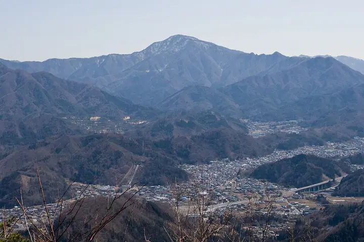
Mount Mishōtai is a 1,682 m peak straddling Tsuru City and Doshi Village in Minamitsuru District, Yamanashi Prefecture, the highest summit of the Doshi mountain range. Long revered as the seat of the deity Mishōtai-Daigongen, the peak has a deep religious history; Crown Prince Naruhito (now the Emperor) climbed it in 2004. It is listed in the Nihon Nihyaku Meizan, the Yamanashi Hyakumeizan, the Tsuru 21 Peaks, the Kantō 100 Mountains, and the Nihon Hyaku Reizan among others. The two main trails on the Tsuru side — the Hosono route from Miwa Shrine and the Shika-domari/Ike-no-taira route — are the standard ascents, and the Ike-no-taira approach offers ridge views of Mount Fuji rising directly behind. The summit is enclosed in a quiet, deep forest of beech and oak with overlooks toward Fuji and Lake Yamanaka.
Mount Mishōtai at a glance
- Weather: The most settled day in the next 7 days is Fri, November 6: clear, gusts up to 7 m/s.
Mount Mishōtai weather (hourly, 14 days)
Sunrise today 06:07, sunset 16:49
| Tue, 11/3 | Wed, 11/4 | Thu, 11/5 | Fri, 11/6 | Sat, 11/7 | Sun, 11/8 | Mon, 11/9 | Tue, 11/10 | Wed, 11/11 | Thu, 11/12 | Fri, 11/13 | Sat, 11/14 | Sun, 11/15 | Mon, 11/16 | Tue, 11/17 | |||||||||||||||||||||||||||||||||||||||||||||||||||||||||||||||||||||||
|---|---|---|---|---|---|---|---|---|---|---|---|---|---|---|---|---|---|---|---|---|---|---|---|---|---|---|---|---|---|---|---|---|---|---|---|---|---|---|---|---|---|---|---|---|---|---|---|---|---|---|---|---|---|---|---|---|---|---|---|---|---|---|---|---|---|---|---|---|---|---|---|---|---|---|---|---|---|---|---|---|---|---|---|---|---|
| Japan time | 15 | 17 | 19 | 21 | 23 | 1 | 3 | 5 | 7 | 9 | 11 | 13 | 15 | 18 | 21 | 0 | 3 | 6 | 9 | 12 | 15 | 18 | 21 | 0 | 3 | 6 | 9 | 12 | 15 | 18 | 21 | 0 | 3 | 6 | 9 | 12 | 15 | 18 | 21 | 0 | 3 | 6 | 9 | 12 | 15 | 18 | 21 | 0 | 3 | 6 | 9 | 15 | 21 | 3 | 9 | 15 | 21 | 3 | 9 | 15 | 21 | 3 | 9 | 15 | 21 | 3 | 9 | 15 | 21 | 3 | 9 | 15 | 21 | 3 | 9 | 15 | 21 | 3 | 9 | 15 | 21 | 3 | 9 | 15 | |
  |   | | | | | |   |   | | | | | | | | | | |   | | | | |   | |  | |   |  | |   | | | | | | | |   | | | | | | | | | | |   | | | | | | | | | |   |  | | | | | | | | | | | | | | | | | | | | | | | ||
| Temperature | °C | 8° | 6° | 6° | 6° | 5° | 5° | 4° | 3° | 3° | 4° | 6° | 5° | 4° | 3° | 3° | 4° | 4° | 5° | 7° | 12° | 10° | 8° | 6° | 4° | 4° | 4° | 11° | 15° | 13° | 8° | 6° | 6° | 6° | 4° | 8° | 10° | 6° | 4° | 3° | 3° | 3° | 2° | 6° | 9° | 6° | 4° | 3° | 3° | 3° | 2° | 4° | 5° | 2° | 1° | 3° | 6° | 2° | -1° | 3° | 6° | -2° | -3° | 3° | 5° | 2° | -2° | 6° | 8° | 1° | 0° | 2° | 4° | 1° | -1° | 7° | 10° | 6° | 6° | 11° | 14° | 4° | 4° | 1° | 3° |
| Precipitation | mm | 1.1 | 0.4 | 0.5 | 0.8 | 0.2 | 0.2 | 0.2 | 0.2 | 0.5 | 0.6 | 1.3 | 4.2 | 11 | 19 | 9 | 5 | 0.8 | 1.8 | 0.2 | 0.4 | 2.2 | 0.3 | 1.3 | 1.6 | 0.2 | 0.3 | 0.6 | 0.3 | 0.1 | 0.4 | 0.1 | 10 | 25 | 0.8 | 0.5 | 0.2 | ||||||||||||||||||||||||||||||||||||||||||||||||
| New snow | cm | ||||||||||||||||||||||||||||||||||||||||||||||||||||||||||||||||||||||||||||||||||||
| Snow depth | cm | 0 | 0 | 0 | 0 | 0 | 0 | 0 | 0 | 0 | 0 | 0 | 0 | 0 | 0 | 0 | 0 | 0 | 0 | 0 | 0 | 0 | 0 | 0 | 0 | 0 | 0 | 0 | 0 | 0 | 0 | 0 | 0 | 0 | 0 | 0 | 0 | 0 | 0 | 0 | 0 | 0 | 0 | 0 | 0 | 0 | 0 | 0 | 0 | 0 | 0 | 0 | 0 | 0 | 0 | 0 | 0 | 0 | 0 | 0 | 0 | 0 | 0 | 0 | 0 | 0 | 0 | 0 | 0 | 0 | 0 | 0 | 0 | 0 | 0 | 0 | 0 | 0 | 0 | 0 | 0 | 0 | 0 | 0 | 0 |
| Wind | m/s | 2 | 1 | 1 | 1 | 1 | 1 | 2 | 2 | 2 | 1 | 2 | 2 | 2 | 1 | 1 | 2 | 2 | 2 | 2 | 2 | 2 | 0 | 1 | 1 | 1 | 1 | 1 | 1 | 2 | 1 | 1 | 1 | 2 | 1 | 1 | 1 | 2 | 2 | 0 | 1 | 1 | 0 | 1 | 2 | 3 | 1 | 1 | 1 | 1 | 1 | 1 | 3 | 2 | 3 | 2 | 4 | 1 | 1 | 6 | 4 | 1 | 1 | 1 | 2 | 1 | 1 | 2 | 2 | 1 | 1 | 1 | 2 | 0 | 1 | 1 | 2 | 1 | 0 | 1 | 1 | 2 | 1 | 1 | 2 |
| Wind gusts | m/s | 7 | 6 | 3 | 3 | 3 | 3 | 4 | 4 | 4 | 4 | 5 | 5 | 5 | 5 | 4 | 5 | 5 | 6 | 7 | 8 | 5 | 5 | 3 | 3 | 4 | 4 | 4 | 5 | 7 | 5 | 3 | 3 | 5 | 4 | 5 | 6 | 7 | 6 | 4 | 2 | 2 | 2 | 4 | 7 | 10 | 8 | 3 | 3 | 3 | 3 | 4 | 9 | 7 | 7 | 7 | 10 | 10 | 4 | 20 | 18 | 10 | 3 | 4 | 7 | 6 | 4 | 6 | 10 | 5 | 3 | 4 | 6 | 6 | 3 | 4 | 9 | 6 | 5 | 4 | 7 | 5 | 5 | 5 | 7 |
| Wind dir. | ↓ | ↓ | ↓ | ↓ | ↓ | ↓ | ↓ | ↓ | ↓ | ↓ | ↓ | ↓ | ↓ | ↓ | ↓ | ↓ | ↓ | ↓ | ↓ | ↓ | ↓ | ↓ | ↓ | ↓ | ↓ | ↓ | ↓ | ↓ | ↓ | ↓ | ↓ | ↓ | ↓ | ↓ | ↓ | ↓ | ↓ | ↓ | ↓ | ↓ | ↓ | ↓ | ↓ | ↓ | ↓ | ↓ | ↓ | ↓ | ↓ | ↓ | ↓ | ↓ | ↓ | ↓ | ↓ | ↓ | ↓ | ↓ | ↓ | ↓ | ↓ | ↓ | ↓ | ↓ | ↓ | ↓ | ↓ | ↓ | ↓ | ↓ | ↓ | ↓ | ↓ | ↓ | ↓ | ↓ | ↓ | ↓ | ↓ | ↓ | ↓ | ↓ | ↓ | ||
Huts, campsites and lodging near Mount Mishōtai
Campsites
- 奥道志オートキャンプ場
- オートキャンプ長又
- とやの沢オートキャンプ場
- センタービレッジキャンプ場
- 山伏オートキャンプ場
Lodging
- 松葉荘
- 丸水荘
- 山光荘
- 旧南荘
- 丸杉荘
Lists that include Mount Mishōtai
Japan 200 Famous Mountains · Japan's 300 Famous Mountains · Koshinetsu 100 Famous Mountains · Yamanashi 100 Famous Mountains · 21 Outstanding Peaks of Tsuru City (Yamanashi Prefecture) · Elevations of 1003 Mountains of Japan · 1000 Mountains of Japan
Mount Mishōtai facts
- Also known as
- マコゼンノ丸
- Elevation
- 1,682 m
- Location
- Tsuru, Yamanashi
35.486904, 138.931695 - Website
- www.city.tsuru.yamanashi.jp
- Trail Map
- www.pref.yamanashi.jp (PDF)
- Wikipedia
- ja.wikipedia.org