
Mount Misen
弥山
Hatsukaichi, Hiroshima · Elevation 535 m
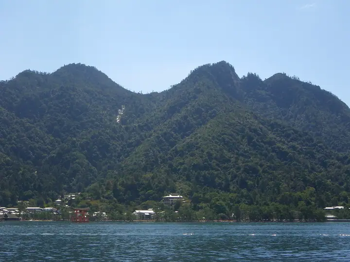
Mount Misen (535 m) rises at the centre of Miyajima (Itsukushima) in Hatsukaichi City, Hiroshima, within the Setonaikai National Park. Sacred to Itsukushima Shrine — part of the UNESCO World Heritage site — the mountain was opened in 806 by Kūkai (Kōbō-Daishi), and the Reikadō hall still tends a perpetual flame said to have burned for over 1,200 years. Three official trails (Daishōin, Momijidani and Daimoto) are maintained by the Miyajima Tourism Association; visitors who ride the Miyajima Ropeway can reach the summit in about 30 minutes from the top station. The peak is included in the Hundred New Famous Mountains of Japan.
Mount Misen at a glance
- Weather: The most settled day in the next 7 days is Sat, November 7: clear, gusts up to 6 m/s.
- Route: The shortest is Mount Misen Momijidani Route from Oku-Momijidani Bridge: about 2 h 18 min, 3.5 km, about 540 m of climbing.
Mount Misen weather (hourly, 14 days)
Sunrise today 06:32, sunset 17:17
| Tue, 11/3 | Wed, 11/4 | Thu, 11/5 | Fri, 11/6 | Sat, 11/7 | Sun, 11/8 | Mon, 11/9 | Tue, 11/10 | Wed, 11/11 | Thu, 11/12 | Fri, 11/13 | Sat, 11/14 | Sun, 11/15 | Mon, 11/16 | Tue, 11/17 | |||||||||||||||||||||||||||||||||||||||||||||||||||||||||||||||||||||||
|---|---|---|---|---|---|---|---|---|---|---|---|---|---|---|---|---|---|---|---|---|---|---|---|---|---|---|---|---|---|---|---|---|---|---|---|---|---|---|---|---|---|---|---|---|---|---|---|---|---|---|---|---|---|---|---|---|---|---|---|---|---|---|---|---|---|---|---|---|---|---|---|---|---|---|---|---|---|---|---|---|---|---|---|---|---|
| Japan time | 15 | 17 | 19 | 21 | 23 | 1 | 3 | 5 | 7 | 9 | 11 | 13 | 15 | 18 | 21 | 0 | 3 | 6 | 9 | 12 | 15 | 18 | 21 | 0 | 3 | 6 | 9 | 12 | 15 | 18 | 21 | 0 | 3 | 6 | 9 | 12 | 15 | 18 | 21 | 0 | 3 | 6 | 9 | 12 | 15 | 18 | 21 | 0 | 3 | 6 | 9 | 15 | 21 | 3 | 9 | 15 | 21 | 3 | 9 | 15 | 21 | 3 | 9 | 15 | 21 | 3 | 9 | 15 | 21 | 3 | 9 | 15 | 21 | 3 | 9 | 15 | 21 | 3 | 9 | 15 | 21 | 3 | 9 | 15 | |
  |   |   | | | |   | | | | |   | | |   | | | |   | | |   | |   | | | |  | |  | | | | | | | | | | | | | | | | | | | | | |   | |   | | | | | | | | | | |  | | | | | | | | |   | |   | | | | | |  | | | ||
| Temperature | °C | 18° | 15° | 14° | 13° | 13° | 12° | 12° | 12° | 11° | 13° | 14° | 15° | 15° | 15° | 14° | 14° | 13° | 14° | 14° | 15° | 16° | 16° | 16° | 16° | 16° | 15° | 15° | 17° | 15° | 12° | 11° | 11° | 10° | 9° | 10° | 12° | 13° | 11° | 9° | 8° | 8° | 8° | 10° | 12° | 13° | 13° | 12° | 12° | 12° | 11° | 12° | 14° | 11° | 10° | 11° | 13° | 11° | 9° | 9° | 13° | 9° | 7° | 8° | 12° | 10° | 9° | 11° | 13° | 9° | 8° | 9° | 13° | 13° | 11° | 12° | 13° | 14° | 14° | 15° | 16° | 11° | 8° | 8° | 12° |
| Precipitation | mm | 0.5 | 1.4 | 0.2 | 0.4 | 0.2 | 0.7 | 4.3 | 0.7 | 0.1 | 0.5 | 0.1 | 0.1 | 6 | 17 | ||||||||||||||||||||||||||||||||||||||||||||||||||||||||||||||||||||||
| New snow | cm | ||||||||||||||||||||||||||||||||||||||||||||||||||||||||||||||||||||||||||||||||||||
| Snow depth | cm | 0 | 0 | 0 | 0 | 0 | 0 | 0 | 0 | 0 | 0 | 0 | 0 | 0 | 0 | 0 | 0 | 0 | 0 | 0 | 0 | 0 | 0 | 0 | 0 | 0 | 0 | 0 | 0 | 0 | 0 | 0 | 0 | 0 | 0 | 0 | 0 | 0 | 0 | 0 | 0 | 0 | 0 | 0 | 0 | 0 | 0 | 0 | 0 | 0 | 0 | 0 | 0 | 0 | 0 | 0 | 0 | 0 | 0 | 0 | 0 | 0 | 0 | 0 | 0 | 0 | 0 | 0 | 0 | 0 | 0 | 0 | 0 | 0 | 0 | 0 | 0 | 0 | 0 | 0 | 0 | 0 | 0 | 0 | 0 |
| Wind | m/s | 3 | 6 | 6 | 5 | 5 | 5 | 5 | 5 | 5 | 5 | 4 | 3 | 3 | 3 | 4 | 4 | 3 | 2 | 3 | 1 | 1 | 2 | 3 | 2 | 3 | 2 | 1 | 5 | 5 | 4 | 3 | 4 | 4 | 4 | 3 | 2 | 3 | 4 | 3 | 3 | 3 | 4 | 5 | 3 | 2 | 2 | 4 | 3 | 3 | 3 | 2 | 1 | 3 | 2 | 1 | 5 | 3 | 6 | 2 | 5 | 3 | 2 | 1 | 4 | 3 | 2 | 4 | 5 | 5 | 5 | 5 | 2 | 3 | 3 | 3 | 4 | 2 | 1 | 1 | 5 | 7 | 5 | 5 | 2 |
| Wind gusts | m/s | 5 | 9 | 10 | 9 | 8 | 8 | 8 | 8 | 8 | 8 | 8 | 7 | 6 | 5 | 6 | 6 | 6 | 6 | 5 | 5 | 3 | 6 | 5 | 6 | 5 | 4 | 4 | 7 | 7 | 7 | 6 | 6 | 6 | 6 | 6 | 6 | 5 | 7 | 7 | 6 | 6 | 6 | 7 | 8 | 6 | 5 | 6 | 6 | 5 | 5 | 5 | 6 | 7 | 5 | 4 | 8 | 7 | 9 | 9 | 7 | 8 | 6 | 5 | 7 | 7 | 5 | 6 | 8 | 8 | 8 | 8 | 7 | 4 | 5 | 6 | 9 | 9 | 4 | 3 | 6 | 11 | 11 | 9 | 8 |
| Wind dir. | ↓ | ↓ | ↓ | ↓ | ↓ | ↓ | ↓ | ↓ | ↓ | ↓ | ↓ | ↓ | ↓ | ↓ | ↓ | ↓ | ↓ | ↓ | ↓ | ↓ | ↓ | ↓ | ↓ | ↓ | ↓ | ↓ | ↓ | ↓ | ↓ | ↓ | ↓ | ↓ | ↓ | ↓ | ↓ | ↓ | ↓ | ↓ | ↓ | ↓ | ↓ | ↓ | ↓ | ↓ | ↓ | ↓ | ↓ | ↓ | ↓ | ↓ | ↓ | ↓ | ↓ | ↓ | ↓ | ↓ | ↓ | ↓ | ↓ | ↓ | ↓ | ↓ | ↓ | ↓ | ↓ | ↓ | ↓ | ↓ | ↓ | ↓ | ↓ | ↓ | ↓ | ↓ | ↓ | ↓ | ↓ | ↓ | ↓ | ↓ | ↓ | ↓ | ↓ | ↓ | |
Mount Misen hiking routes
- Mount Misen Momijidani Route from Oku-Momijidani Bridge 3.5 km · Ascent 539 m 紅葉谷駅 (Aerialway station), Momijidani (Aerialway station) → 獅子岩駅 (Aerialway station), Shishiiwa (Aerialway station)
- Mount Misen via the Daishoin Course 5.4 km · Ascent 543 m 不明門
- Mount Misen and Sankensan Round Trip via the Omoto Course 7.2 km · Ascent 675 m 不明門
- Mount Misen Circuit from Miyajima Pier via the Momijidani and Daishoin Courses 7.5 km · Ascent 534 m Miyajima Ferry Terminal (Ferry terminal), フェリー待機場 (parking)
- Miyajima Ferry Terminal–Mount Misen Return via Momijidani Route 8.2 km · Ascent 538 m Miyajima Ferry Terminal (Ferry terminal), フェリー待機場 (parking)
- Mount Misen Omoto–Momijidani Loop 12.9 km · Ascent 818 m Miyajima Ferry Terminal (Ferry terminal), フェリー待機場 (parking)
Hiking times are estimates calculated from the terrain.
Huts, campsites and lodging near Mount Misen
Campsites
- Tsutsumigaura Recreation Park
Lodging
- Watanabe Ryokan
- Kikunoya
- Miyajima Guest House Mikuniya
- Momijiso Ryokan
- Iwaso
Lists that include Mount Misen
New Japan 100 Famous Mountains · 100 Low Mountains of Japan · Chugoku 100 Famous Mountains · 100 Selected Island Mountains · Hiroshima Prefecture 100 Famous Mountains · Hatsukaichi 20 Remarkable Mountains · Elevations of 1003 Mountains of Japan · 1000 Mountains of Japan
Mount Misen facts
- Elevation
- 535 m
- Location
- Hatsukaichi, Hiroshima
34.279591, 132.319610 - National Park
- 瀬戸内海国立公園
- Website
- www.miyajima.or.jp
- Trail Map
- www.miyajima.or.jp
- Wikipedia
- ja.wikipedia.org