
Mount Megami
女神山
Misato, Akita · Elevation 955 m
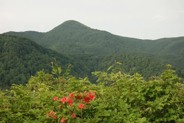
Mount Megami is a 955.3 m peak straddling the Iwate–Akita prefectural border between Nishiwaga Town (Iwate) and Higashinaruse Village (Akita), at the southern end of the Mahiru Mountains between the Ōu Mountains and the Kitakami Highlands. Its slopes hold the photogenic Shiraito and Uba waterfalls amid mature beech forest and gorge scenery. The mountain features in many regional lists, including the Tōhoku 100 Mountains, Iwate 100 Mountains, and the Yama-Kei prefectural guides for Iwate and Akita.
Mount Megami at a glance
- Weather: The most settled day in the next 7 days is Wed, November 4: clear, gusts up to 9 m/s. Fri, Nov 6, Sat, Nov 7, Sun, Nov 8: strong wind (gusts up to 24 m/s).
Mount Megami weather (hourly, 14 days)
Sunrise today 06:07, sunset 16:35
| Tue, 11/3 | Wed, 11/4 | Thu, 11/5 | Fri, 11/6 | Sat, 11/7 | Sun, 11/8 | Mon, 11/9 | Tue, 11/10 | Wed, 11/11 | Thu, 11/12 | Fri, 11/13 | Sat, 11/14 | Sun, 11/15 | Mon, 11/16 | Tue, 11/17 | |||||||||||||||||||||||||||||||||||||||||||||||||||||||||||||||||||||||
|---|---|---|---|---|---|---|---|---|---|---|---|---|---|---|---|---|---|---|---|---|---|---|---|---|---|---|---|---|---|---|---|---|---|---|---|---|---|---|---|---|---|---|---|---|---|---|---|---|---|---|---|---|---|---|---|---|---|---|---|---|---|---|---|---|---|---|---|---|---|---|---|---|---|---|---|---|---|---|---|---|---|---|---|---|---|
| Japan time | 15 | 17 | 19 | 21 | 23 | 1 | 3 | 5 | 7 | 9 | 11 | 13 | 15 | 18 | 21 | 0 | 3 | 6 | 9 | 12 | 15 | 18 | 21 | 0 | 3 | 6 | 9 | 12 | 15 | 18 | 21 | 0 | 3 | 6 | 9 | 12 | 15 | 18 | 21 | 0 | 3 | 6 | 9 | 12 | 15 | 18 | 21 | 0 | 3 | 6 | 9 | 15 | 21 | 3 | 9 | 15 | 21 | 3 | 9 | 15 | 21 | 3 | 9 | 15 | 21 | 3 | 9 | 15 | 21 | 3 | 9 | 15 | 21 | 3 | 9 | 15 | 21 | 3 | 9 | 15 | 21 | 3 | 9 | 15 | |
 |  |   | |   | |   | |   |   | | |   | | | |   |   |   |   | | | | | | | | | | | | | |   |   | | | |   |   | | | | |   | | | | | | | | | | | | | | | | | | | | | | | | | | | |  | | | | | | | |   | | | | ||
| Temperature | °C | 6° | 3° | 2° | 1° | 0° | 1° | 1° | 2° | 2° | 6° | 9° | 10° | 9° | 3° | 1° | 1° | 3° | 5° | 7° | 8° | 9° | 7° | 6° | 7° | 7° | 7° | 9° | 9° | 8° | 5° | 2° | 1° | 0° | -1° | 0° | 1° | -1° | -2° | -1° | 0° | -1° | -1° | 2° | 3° | 2° | 1° | -1° | -1° | -1° | -2° | 2° | 2° | -2° | -2° | 2° | 5° | 0° | 2° | 3° | 3° | -2° | -2° | 2° | 4° | 2° | 1° | 1° | 2° | -2° | -4° | 1° | 4° | -2° | -2° | 5° | 8° | 6° | 4° | 6° | 3° | -2° | -2° | 1° | 3° |
| Precipitation | mm | 0.3 | 0.9 | 0.1 | 1.1 | 3.6 | 3.0 | 0.7 | 0.2 | 0.3 | 0.8 | 1.1 | 0.2 | 2.5 | 4.7 | 2.6 | 2.1 | 3.0 | 2.8 | 3.1 | 3.5 | 2.1 | 3.6 | 2.9 | 2.3 | 1.9 | 0.2 | 0.7 | 0.7 | 0.1 | 2.2 | 6 | 3.6 | 0.7 | 0.3 | 7 | 0.4 | 0.2 | 4.7 | 2.2 | 1.8 | 2.7 | |||||||||||||||||||||||||||||||||||||||||||
| New snow | cm | 0.6 | 0.6 | 2.2 | 1.7 | 1.1 | 1.2 | <.1 | 0.2 | <.1 | 0.2 | ||||||||||||||||||||||||||||||||||||||||||||||||||||||||||||||||||||||||||
| Snow depth | cm | 0 | 0 | 0 | 0 | 0 | 0 | 0 | 0 | 0 | 0 | 0 | 0 | 0 | 0 | 0 | 0 | 0 | 0 | 0 | 0 | 0 | 0 | 0 | 0 | 0 | 0 | 0 | 0 | 0 | 0 | 0 | 0 | 0 | <1 | <1 | 1 | 1 | 1 | 2 | 2 | 1 | 1 | <1 | <1 | 0 | 0 | 0 | 0 | 0 | 0 | 0 | 0 | 0 | 0 | 0 | 0 | 0 | 0 | 0 | 0 | 0 | 0 | 0 | 0 | 0 | 0 | 0 | 0 | 0 | 0 | 0 | 0 | 0 | 0 | 0 | 0 | 0 | 0 | 0 | 0 | 0 | 0 | 0 | 0 |
| Wind | m/s | 6 | 3 | 2 | 1 | 1 | 1 | 0 | 1 | 1 | 1 | 3 | 3 | 2 | 1 | 2 | 3 | 3 | 2 | 2 | 2 | 1 | 1 | 1 | 1 | 1 | 1 | 1 | 5 | 5 | 5 | 7 | 4 | 5 | 3 | 6 | 7 | 8 | 5 | 6 | 6 | 5 | 6 | 8 | 9 | 8 | 4 | 3 | 2 | 1 | 0 | 2 | 4 | 1 | 1 | 1 | 5 | 5 | 3 | 2 | 3 | 0 | 0 | 0 | 3 | 2 | 1 | 4 | 6 | 2 | 1 | 0 | 3 | 1 | 0 | 1 | 1 | 3 | 1 | 1 | 5 | 5 | 2 | 1 | 3 |
| Wind gusts | m/s | 15 | 14 | 9 | 6 | 5 | 6 | 5 | 5 | 5 | 5 | 9 | 9 | 9 | 5 | 5 | 7 | 8 | 8 | 7 | 6 | 5 | 5 | 4 | 4 | 4 | 4 | 5 | 15 | 18 | 16 | 17 | 17 | 13 | 15 | 17 | 22 | 23 | 20 | 18 | 16 | 16 | 15 | 20 | 23 | 24 | 19 | 11 | 8 | 6 | 5 | 7 | 12 | 9 | 3 | 4 | 12 | 19 | 15 | 10 | 10 | 8 | 3 | 4 | 9 | 8 | 6 | 10 | 15 | 14 | 6 | 4 | 8 | 7 | 2 | 3 | 6 | 9 | 9 | 4 | 14 | 16 | 13 | 7 | 10 |
| Wind dir. | ↓ | ↓ | ↓ | ↓ | ↓ | ↓ | ↓ | ↓ | ↓ | ↓ | ↓ | ↓ | ↓ | ↓ | ↓ | ↓ | ↓ | ↓ | ↓ | ↓ | ↓ | ↓ | ↓ | ↓ | ↓ | ↓ | ↓ | ↓ | ↓ | ↓ | ↓ | ↓ | ↓ | ↓ | ↓ | ↓ | ↓ | ↓ | ↓ | ↓ | ↓ | ↓ | ↓ | ↓ | ↓ | ↓ | ↓ | ↓ | ↓ | ↓ | ↓ | ↓ | ↓ | ↓ | ↓ | ↓ | ↓ | ↓ | ↓ | ↓ | ↓ | ↓ | ↓ | ↓ | ↓ | ↓ | ↓ | ↓ | ↓ | ↓ | ↓ | ↓ | ↓ | ↓ | ↓ | ↓ | ↓ | ↓ | ↓ | ↓ | ↓ | ↓ | ↓ | ↓ | |
Lists that include Mount Megami
Mount Megami facts
- Elevation
- 955 m
- Location
- Misato, Akita
39.416979, 140.675114 - Website
- www.town.nishiwaga.lg.jp
- Trail Map
- www.town.nishiwaga.lg.jp (PDF)
- Access Information
- www.town.nishiwaga.lg.jp
- Wikipedia
- ja.wikipedia.org