
Mt. Mahirudake
真昼岳
Misato, Akita / Nishiwaga, Iwate · Elevation 1,059 m
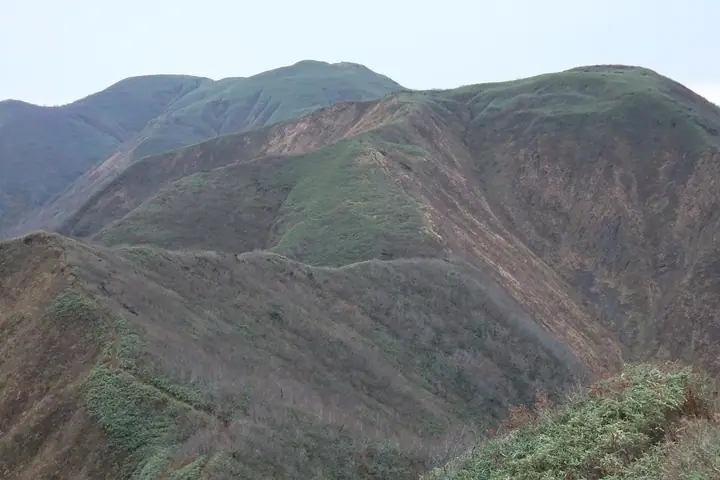
Mt. Mahirudake is a 1,059-meter peak on the border between Nishiwaga Town in Waga District of Iwate Prefecture and Misato Town in Senboku District and Daisen City of Akita Prefecture — the principal summit of the Mahiru Range in the central Ōu Mountains. The Akita side falls within the Maki-Mahiru Prefectural Natural Park, with old-growth beech forest and a chain of stream-side waterfalls. From Iwate, the Usagidaira trailhead via Prefectural Route 1 and the Minekoshi forest road is a three-hour climb; the Akita-side Minekoshi route reaches the summit in about two hours, and a ridge traverse to Megami-dake of roughly two hours crosses alpine flower meadows. The peak is included in the Tōhoku Hyakumeizan, Iwate Hyakumeizan, and Shin Iwate-no-20 Meizan lists.
Mt. Mahirudake at a glance
- Weather: The most settled day in the next 7 days is Wed, November 4: clear, gusts up to 9 m/s. Fri, Nov 6, Sat, Nov 7, Sun, Nov 8: strong wind (gusts up to 24 m/s).
Mt. Mahirudake weather (hourly, 14 days)
Sunrise today 06:07, sunset 16:35
| Tue, 11/3 | Wed, 11/4 | Thu, 11/5 | Fri, 11/6 | Sat, 11/7 | Sun, 11/8 | Mon, 11/9 | Tue, 11/10 | Wed, 11/11 | Thu, 11/12 | Fri, 11/13 | Sat, 11/14 | Sun, 11/15 | Mon, 11/16 | Tue, 11/17 | |||||||||||||||||||||||||||||||||||||||||||||||||||||||||||||||||||||||
|---|---|---|---|---|---|---|---|---|---|---|---|---|---|---|---|---|---|---|---|---|---|---|---|---|---|---|---|---|---|---|---|---|---|---|---|---|---|---|---|---|---|---|---|---|---|---|---|---|---|---|---|---|---|---|---|---|---|---|---|---|---|---|---|---|---|---|---|---|---|---|---|---|---|---|---|---|---|---|---|---|---|---|---|---|---|
| Japan time | 15 | 17 | 19 | 21 | 23 | 1 | 3 | 5 | 7 | 9 | 11 | 13 | 15 | 18 | 21 | 0 | 3 | 6 | 9 | 12 | 15 | 18 | 21 | 0 | 3 | 6 | 9 | 12 | 15 | 18 | 21 | 0 | 3 | 6 | 9 | 12 | 15 | 18 | 21 | 0 | 3 | 6 | 9 | 12 | 15 | 18 | 21 | 0 | 3 | 6 | 9 | 15 | 21 | 3 | 9 | 15 | 21 | 3 | 9 | 15 | 21 | 3 | 9 | 15 | 21 | 3 | 9 | 15 | 21 | 3 | 9 | 15 | 21 | 3 | 9 | 15 | 21 | 3 | 9 | 15 | 21 | 3 | 9 | 15 | |
 |  |   | |   | |   | |   |   | | |   | | | |   |   |   |   | | | | | | | | | | | | | |   |   | | | |   |   | | | | |   | | | | | | | | | | | | | | | | | | | | | | | | | | | |  | | | | | | | |   | | | | ||
| Temperature | °C | 5° | 3° | 1° | 1° | 0° | 0° | 1° | 1° | 1° | 5° | 8° | 9° | 8° | 3° | 1° | 1° | 2° | 4° | 6° | 7° | 8° | 6° | 6° | 7° | 6° | 7° | 8° | 9° | 8° | 5° | 2° | 0° | -1° | -2° | -1° | 0° | -1° | -2° | -1° | -1° | -2° | -2° | 1° | 2° | 1° | 0° | -1° | -1° | -1° | -3° | 2° | 1° | -3° | -2° | 1° | 4° | 0° | 1° | 2° | 3° | -3° | -2° | 2° | 3° | 1° | 1° | 0° | 1° | -3° | -5° | 1° | 4° | -2° | -3° | 4° | 8° | 5° | 3° | 6° | 2° | -3° | -2° | 0° | 2° |
| Precipitation | mm | 0.3 | 0.9 | 0.1 | 1.1 | 3.6 | 3.0 | 0.7 | 0.2 | 0.3 | 0.8 | 1.1 | 0.2 | 2.5 | 4.7 | 2.6 | 2.1 | 3.0 | 2.8 | 3.1 | 3.5 | 2.1 | 3.6 | 2.9 | 2.3 | 1.9 | 0.2 | 0.7 | 0.7 | 0.1 | 2.2 | 6 | 3.6 | 0.7 | 0.3 | 7 | 0.4 | 0.2 | 4.7 | 2.2 | 1.8 | 2.7 | |||||||||||||||||||||||||||||||||||||||||||
| New snow | cm | 0.6 | 0.6 | 2.2 | 1.7 | 1.1 | 1.2 | <.1 | 0.2 | <.1 | 0.2 | ||||||||||||||||||||||||||||||||||||||||||||||||||||||||||||||||||||||||||
| Snow depth | cm | 0 | 0 | 0 | 0 | 0 | 0 | 0 | 0 | 0 | 0 | 0 | 0 | 0 | 0 | 0 | 0 | 0 | 0 | 0 | 0 | 0 | 0 | 0 | 0 | 0 | 0 | 0 | 0 | 0 | 0 | 0 | 0 | 0 | <1 | <1 | 1 | 1 | 1 | 2 | 2 | 1 | 1 | <1 | <1 | 0 | 0 | 0 | 0 | 0 | 0 | 0 | 0 | 0 | 0 | 0 | 0 | 0 | 0 | 0 | 0 | 0 | 0 | 0 | 0 | 0 | 0 | 0 | 0 | 0 | 0 | 0 | 0 | 0 | 0 | 0 | 0 | 0 | 0 | 0 | 0 | 0 | 0 | 0 | 0 |
| Wind | m/s | 6 | 3 | 2 | 1 | 1 | 1 | 0 | 1 | 1 | 1 | 3 | 3 | 2 | 1 | 2 | 3 | 3 | 2 | 2 | 2 | 1 | 1 | 1 | 1 | 1 | 1 | 1 | 5 | 5 | 5 | 7 | 4 | 5 | 3 | 6 | 7 | 8 | 5 | 6 | 6 | 5 | 6 | 8 | 9 | 8 | 4 | 3 | 2 | 1 | 0 | 2 | 4 | 1 | 1 | 1 | 5 | 5 | 3 | 2 | 3 | 0 | 0 | 0 | 3 | 2 | 1 | 4 | 6 | 2 | 1 | 0 | 3 | 1 | 0 | 1 | 1 | 3 | 1 | 1 | 5 | 5 | 2 | 1 | 3 |
| Wind gusts | m/s | 15 | 14 | 9 | 6 | 5 | 6 | 5 | 5 | 5 | 5 | 9 | 9 | 9 | 5 | 5 | 7 | 8 | 8 | 7 | 6 | 5 | 5 | 4 | 4 | 4 | 4 | 5 | 15 | 18 | 16 | 17 | 17 | 13 | 15 | 17 | 22 | 23 | 20 | 18 | 16 | 16 | 15 | 20 | 23 | 24 | 19 | 11 | 8 | 6 | 5 | 7 | 12 | 9 | 3 | 4 | 12 | 19 | 15 | 10 | 10 | 8 | 3 | 4 | 9 | 8 | 6 | 10 | 15 | 14 | 6 | 4 | 8 | 7 | 2 | 3 | 6 | 9 | 9 | 4 | 14 | 16 | 13 | 7 | 10 |
| Wind dir. | ↓ | ↓ | ↓ | ↓ | ↓ | ↓ | ↓ | ↓ | ↓ | ↓ | ↓ | ↓ | ↓ | ↓ | ↓ | ↓ | ↓ | ↓ | ↓ | ↓ | ↓ | ↓ | ↓ | ↓ | ↓ | ↓ | ↓ | ↓ | ↓ | ↓ | ↓ | ↓ | ↓ | ↓ | ↓ | ↓ | ↓ | ↓ | ↓ | ↓ | ↓ | ↓ | ↓ | ↓ | ↓ | ↓ | ↓ | ↓ | ↓ | ↓ | ↓ | ↓ | ↓ | ↓ | ↓ | ↓ | ↓ | ↓ | ↓ | ↓ | ↓ | ↓ | ↓ | ↓ | ↓ | ↓ | ↓ | ↓ | ↓ | ↓ | ↓ | ↓ | ↓ | ↓ | ↓ | ↓ | ↓ | ↓ | ↓ | ↓ | ↓ | ↓ | ↓ | ↓ | |
Lists that include Mt. Mahirudake
Tohoku 100 Famous Mountains · Iwate 100 Famous Mountains · Elevations of 1003 Mountains of Japan · 1000 Mountains of Japan
Mt. Mahirudake facts
- Elevation
- 1,059 m
- Location
- Misato, Akita / Nishiwaga, Iwate
39.447867, 140.676541 - Website
- www.town.nishiwaga.lg.jp
- Trail Map
- www.town.nishiwaga.lg.jp (PDF)
- Access Information
- www.town.nishiwaga.lg.jp
- Wikipedia
- ja.wikipedia.org