
Mount Maya
摩耶山
Tsuruoka, Yamagata · Elevation 1,020 m
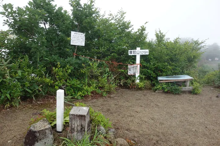
Mount Maya is a 1,019.7 m peak in western Tsuruoka City near the Niigata–Yamagata border, sitting at the northern end of the Asahi mountain range. It is listed in the Nihon Sanbyaku Meizan, the Yamagata Hyakumeizan, the Tōhoku 100 Meizan, and the Nihon 100 Lower Famous Mountains. Despite its modest height, the peak has a steep rocky upper section and a famously expansive summit view, earning the local nickname "the great viewing platform of Bandai-Asahi National Park." Three trailheads serve the mountain — Koshizawa and Sekikawa on the Atsumi side, and Kurasawa on the Asahi side — and seasonal climbing events are held by the Atsumi side in late May and mid-October. Late spring greenery and autumn foliage are the prime climbing seasons.
Mount Maya at a glance
- Weather: The most settled day in the next 7 days is Wed, November 4: cloudy, gusts up to 7 m/s. Fri, Nov 6, Sat, Nov 7, Sun, Nov 8: strong wind (gusts up to 23 m/s).
Mount Maya weather (hourly, 14 days)
Sunrise today 06:09, sunset 16:41
| Tue, 11/3 | Wed, 11/4 | Thu, 11/5 | Fri, 11/6 | Sat, 11/7 | Sun, 11/8 | Mon, 11/9 | Tue, 11/10 | Wed, 11/11 | Thu, 11/12 | Fri, 11/13 | Sat, 11/14 | Sun, 11/15 | Mon, 11/16 | Tue, 11/17 | |||||||||||||||||||||||||||||||||||||||||||||||||||||||||||||||||||||||
|---|---|---|---|---|---|---|---|---|---|---|---|---|---|---|---|---|---|---|---|---|---|---|---|---|---|---|---|---|---|---|---|---|---|---|---|---|---|---|---|---|---|---|---|---|---|---|---|---|---|---|---|---|---|---|---|---|---|---|---|---|---|---|---|---|---|---|---|---|---|---|---|---|---|---|---|---|---|---|---|---|---|---|---|---|---|
| Japan time | 15 | 17 | 19 | 21 | 23 | 1 | 3 | 5 | 7 | 9 | 11 | 13 | 15 | 18 | 21 | 0 | 3 | 6 | 9 | 12 | 15 | 18 | 21 | 0 | 3 | 6 | 9 | 12 | 15 | 18 | 21 | 0 | 3 | 6 | 9 | 12 | 15 | 18 | 21 | 0 | 3 | 6 | 9 | 12 | 15 | 18 | 21 | 0 | 3 | 6 | 9 | 15 | 21 | 3 | 9 | 15 | 21 | 3 | 9 | 15 | 21 | 3 | 9 | 15 | 21 | 3 | 9 | 15 | 21 | 3 | 9 | 15 | 21 | 3 | 9 | 15 | 21 | 3 | 9 | 15 | 21 | 3 | 9 | 15 | |
  |   | | |   | | |   |   | |   |   | | | | | | |   | | | | |   | | | | |   | | | | |   |   | |   |   | | | | | | | | | |   | | | | | | |  | | | | | | | | | | | | | | | | | |  | | | | | | | | |   | | | ||
| Temperature | °C | 6° | 3° | 3° | 2° | 2° | 2° | 3° | 3° | 3° | 7° | 10° | 9° | 9° | 4° | 4° | 7° | 7° | 6° | 8° | 9° | 11° | 7° | 8° | 8° | 8° | 9° | 10° | 11° | 8° | 5° | 3° | 2° | 1° | 0° | 1° | 2° | 1° | 0° | 0° | 0° | 0° | 0° | 1° | 3° | 2° | 2° | 1° | 1° | 1° | -1° | 2° | 1° | -1° | -3° | 3° | 7° | 1° | 0° | 2° | 3° | 1° | 1° | 3° | 3° | 2° | 2° | 2° | 1° | 1° | 0° | 4° | 5° | -4° | -2° | 9° | 10° | 4° | 5° | 7° | 3° | -1° | -1° | 1° | 3° |
| Precipitation | mm | 0.1 | 0.4 | 0.1 | 3.0 | 4.7 | 3.0 | 0.2 | 0.2 | 2.3 | 0.2 | 0.9 | 5 | 3.3 | 4.5 | 4.8 | 5 | 6 | 4.6 | 3.8 | 2.4 | 2.1 | 2.3 | 2.7 | 2.5 | 2.3 | 2.3 | 2.4 | 1.3 | 0.1 | 0.2 | 0.2 | 0.2 | 0.3 | 1.7 | 0.4 | 6 | 18 | 3.9 | 1.8 | 3.5 | 1.2 | 0.4 | 1.3 | 0.8 | 11 | 2.3 | 0.6 | 0.2 | 2.6 | 4.0 | 7 | 11 | 2.6 | 0.3 | 0.2 | |||||||||||||||||||||||||||||
| New snow | cm | <.1 | 0.2 | 0.5 | 0.4 | 0.4 | 0.2 | 0.2 | <.1 | <.1 | <.1 | 0.8 | 0.4 | <.1 | <.1 | <.1 | <.1 | ||||||||||||||||||||||||||||||||||||||||||||||||||||||||||||||||||||
| Snow depth | cm | 0 | 0 | 0 | 0 | 0 | 0 | 0 | 0 | 0 | 0 | 0 | 0 | 0 | 0 | 0 | 0 | 0 | 0 | 0 | 0 | 0 | 0 | 0 | 0 | 0 | 0 | 0 | 0 | 0 | 0 | 0 | 0 | 0 | 0 | <1 | <1 | <1 | <1 | <1 | <1 | <1 | <1 | <1 | <1 | <1 | <1 | <1 | <1 | 0 | 0 | 0 | 0 | 0 | 0 | 0 | 0 | 0 | <1 | <1 | <1 | <1 | <1 | 0 | 0 | 0 | 0 | 0 | 0 | 0 | 0 | 0 | 0 | 0 | 0 | 0 | 0 | 0 | 0 | 0 | 0 | 0 | 0 | 0 | 0 |
| Wind | m/s | 4 | 2 | 1 | 1 | 1 | 2 | 3 | 3 | 3 | 2 | 3 | 2 | 2 | 2 | 3 | 5 | 4 | 4 | 2 | 2 | 1 | 2 | 3 | 3 | 3 | 4 | 4 | 6 | 5 | 4 | 5 | 5 | 5 | 6 | 6 | 8 | 8 | 7 | 7 | 6 | 6 | 5 | 6 | 7 | 5 | 3 | 2 | 2 | 1 | 2 | 1 | 2 | 1 | 1 | 1 | 5 | 5 | 2 | 2 | 5 | 2 | 1 | 3 | 2 | 4 | 4 | 5 | 5 | 3 | 1 | 2 | 2 | 1 | 3 | 3 | 2 | 2 | 1 | 1 | 6 | 5 | 3 | 2 | 1 |
| Wind gusts | m/s | 11 | 9 | 5 | 5 | 4 | 5 | 7 | 7 | 7 | 6 | 7 | 7 | 7 | 6 | 8 | 11 | 12 | 11 | 11 | 6 | 6 | 5 | 7 | 9 | 8 | 11 | 12 | 16 | 16 | 14 | 13 | 14 | 13 | 17 | 18 | 23 | 23 | 21 | 18 | 18 | 16 | 16 | 16 | 17 | 17 | 12 | 9 | 5 | 6 | 4 | 5 | 9 | 5 | 4 | 5 | 11 | 19 | 14 | 9 | 13 | 11 | 6 | 8 | 11 | 10 | 11 | 12 | 13 | 12 | 8 | 5 | 7 | 5 | 6 | 7 | 10 | 9 | 9 | 6 | 16 | 16 | 12 | 7 | 6 |
| Wind dir. | ↓ | ↓ | ↓ | ↓ | ↓ | ↓ | ↓ | ↓ | ↓ | ↓ | ↓ | ↓ | ↓ | ↓ | ↓ | ↓ | ↓ | ↓ | ↓ | ↓ | ↓ | ↓ | ↓ | ↓ | ↓ | ↓ | ↓ | ↓ | ↓ | ↓ | ↓ | ↓ | ↓ | ↓ | ↓ | ↓ | ↓ | ↓ | ↓ | ↓ | ↓ | ↓ | ↓ | ↓ | ↓ | ↓ | ↓ | ↓ | ↓ | ↓ | ↓ | ↓ | ↓ | ↓ | ↓ | ↓ | ↓ | ↓ | ↓ | ↓ | ↓ | ↓ | ↓ | ↓ | ↓ | ↓ | ↓ | ↓ | ↓ | ↓ | ↓ | ↓ | ↓ | ↓ | ↓ | ↓ | ↓ | ↓ | ↓ | ↓ | ↓ | ↓ | ↓ | ↓ | |
Huts, campsites and lodging near Mount Maya
Mountain huts
Lists that include Mount Maya
Japan's 300 Famous Mountains · Tohoku 100 Famous Mountains · Yamagata 100 Famous Mountains · Elevations of 1003 Mountains of Japan · 1000 Mountains of Japan
Mount Maya facts
- Elevation
- 1,020 m
- Location
- Tsuruoka, Yamagata
38.520239, 139.727839 - Website
- www.city.tsuruoka.lg.jp
- Trail Map
- www.city.tsuruoka.lg.jp (PDF)
- Wikipedia
- ja.wikipedia.org