
Mount Futatsumori
二ツ森
Ajigasawa, Aomori / Fujisato, Akita · Elevation 1,086 m
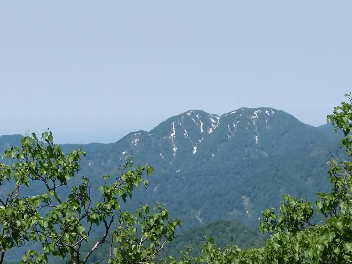
Mount Futatsumori is a 1,086-metre peak on the border of Fujisato Town (Akita) and Ajigasawa Town (Aomori), set in the buffer zone of the Shirakami-Sanchi World Heritage Area. The trailhead lies at the end of the old Seishū Forest Road on the Happō Town side, with the summit reached in roughly 50 minutes — making it one of the most accessible Shirakami viewpoints. The peak appears on Aomori's 110 Famous Mountains and the 100 Low Famous Mountains of Japan.
Mount Futatsumori at a glance
- Weather: The most settled day in the next 7 days is Thu, November 5: cloudy, gusts up to 7 m/s. Fri, Nov 6, Sat, Nov 7, Sun, Nov 8: strong wind (gusts up to 24 m/s).
Mount Futatsumori weather (hourly, 14 days)
Sunrise today 06:11, sunset 16:36
| Tue, 11/3 | Wed, 11/4 | Thu, 11/5 | Fri, 11/6 | Sat, 11/7 | Sun, 11/8 | Mon, 11/9 | Tue, 11/10 | Wed, 11/11 | Thu, 11/12 | Fri, 11/13 | Sat, 11/14 | Sun, 11/15 | Mon, 11/16 | Tue, 11/17 | |||||||||||||||||||||||||||||||||||||||||||||||||||||||||||||||||||||||
|---|---|---|---|---|---|---|---|---|---|---|---|---|---|---|---|---|---|---|---|---|---|---|---|---|---|---|---|---|---|---|---|---|---|---|---|---|---|---|---|---|---|---|---|---|---|---|---|---|---|---|---|---|---|---|---|---|---|---|---|---|---|---|---|---|---|---|---|---|---|---|---|---|---|---|---|---|---|---|---|---|---|---|---|---|---|
| Japan time | 15 | 17 | 19 | 21 | 23 | 1 | 3 | 5 | 7 | 9 | 11 | 13 | 15 | 18 | 21 | 0 | 3 | 6 | 9 | 12 | 15 | 18 | 21 | 0 | 3 | 6 | 9 | 12 | 15 | 18 | 21 | 0 | 3 | 6 | 9 | 12 | 15 | 18 | 21 | 0 | 3 | 6 | 9 | 12 | 15 | 18 | 21 | 0 | 3 | 6 | 9 | 15 | 21 | 3 | 9 | 15 | 21 | 3 | 9 | 15 | 21 | 3 | 9 | 15 | 21 | 3 | 9 | 15 | 21 | 3 | 9 | 15 | 21 | 3 | 9 | 15 | 21 | 3 | 9 | 15 | 21 | 3 | 9 | 15 | |
  |   | | | |   |   | |  | | | | | | | | | |   |   |   |   | | | | |   | | | | |   |   | |   | | | |   | | | |   | | | | | | | | | | | |   | | |   | | | | | | | | | | |   | | | | |  | | | | | |   | | | | | ||
| Temperature | °C | 2° | 0° | 0° | 0° | 1° | 2° | 4° | 2° | 2° | 5° | 6° | 7° | 6° | 1° | 2° | 2° | 3° | 4° | 7° | 9° | 8° | 6° | 5° | 6° | 6° | 5° | 8° | 7° | 5° | 2° | -1° | -3° | -3° | -4° | -3° | -3° | -2° | -3° | -3° | -3° | -4° | -4° | -2° | -1° | -2° | -2° | -3° | -2° | -3° | -5° | -2° | -3° | -5° | -6° | -2° | 0° | -3° | -2° | -2° | -1° | -3° | -2° | 1° | 1° | -1° | -5° | -2° | -2° | -4° | -4° | 1° | 1° | -3° | -3° | 3° | 4° | 2° | 2° | 3° | -1° | -5° | -4° | 0° | 0° |
| Precipitation | mm | 0.1 | 0.2 | 1.1 | 0.3 | 0.3 | 1.1 | 1.4 | 0.3 | 0.4 | 0.8 | 4.9 | 3.0 | 0.5 | 0.2 | 0.5 | 0.9 | 0.8 | 1.4 | 1.5 | 1.4 | 0.8 | 0.9 | 0.9 | 1.4 | 0.5 | 0.3 | 0.3 | 0.4 | 0.5 | 1.5 | 0.3 | 4.8 | 6 | 10 | 0.4 | 0.2 | 0.7 | 6 | 1.3 | 3.9 | 7 | 1.4 | 4.8 | 1.7 | ||||||||||||||||||||||||||||||||||||||||
| New snow | cm | 0.4 | 0.9 | 0.8 | 1.4 | 1.5 | 1.3 | 0.8 | 0.9 | 0.8 | 1.4 | 0.5 | 0.3 | 0.2 | 0.4 | <.1 | <.1 | 0.5 | 1.4 | 0.3 | <.1 | <.1 | 4.7 | 4.2 | 8.3 | 0.3 | 0.9 | 0.1 | <.1 | <.1 | 0.6 | 1.4 | <.1 | ||||||||||||||||||||||||||||||||||||||||||||||||||||
| Snow depth | cm | 0 | 0 | 0 | 0 | 0 | 0 | 0 | 0 | 0 | 0 | 0 | 0 | 0 | 0 | 0 | 0 | 0 | 0 | 0 | 0 | 0 | 0 | 0 | 0 | 0 | 0 | 0 | 0 | 0 | 0 | 0 | 0 | <1 | <1 | 2 | 2 | 3 | 3 | 3 | 4 | 4 | 5 | 5 | 5 | 5 | 5 | 4 | 4 | 4 | 4 | 5 | 5 | 5 | 5 | 5 | 4 | 7 | 9 | 13 | 11 | 11 | 10 | 10 | 8 | 8 | 7 | 7 | 7 | 7 | 7 | 7 | 5 | 5 | 5 | 4 | 2 | 2 | 1 | <1 | <1 | 2 | 2 | <1 | <1 |
| Wind | m/s | 6 | 3 | 4 | 3 | 4 | 5 | 6 | 5 | 4 | 4 | 3 | 2 | 2 | 1 | 1 | 1 | 2 | 2 | 2 | 2 | 2 | 1 | 1 | 1 | 1 | 1 | 3 | 6 | 6 | 8 | 8 | 6 | 7 | 8 | 8 | 8 | 8 | 8 | 8 | 7 | 8 | 7 | 7 | 7 | 6 | 6 | 4 | 3 | 3 | 1 | 3 | 3 | 1 | 2 | 2 | 4 | 5 | 2 | 5 | 2 | 1 | 2 | 5 | 3 | 1 | 2 | 4 | 4 | 2 | 1 | 2 | 2 | 1 | 1 | 1 | 1 | 1 | 0 | 3 | 4 | 3 | 3 | 3 | 2 |
| Wind gusts | m/s | 15 | 14 | 10 | 10 | 10 | 12 | 15 | 15 | 12 | 10 | 10 | 8 | 6 | 4 | 2 | 3 | 4 | 6 | 6 | 7 | 7 | 4 | 3 | 2 | 3 | 4 | 8 | 16 | 17 | 18 | 20 | 19 | 18 | 21 | 22 | 24 | 24 | 22 | 20 | 19 | 19 | 19 | 18 | 18 | 18 | 15 | 13 | 10 | 8 | 7 | 7 | 9 | 7 | 5 | 5 | 9 | 13 | 14 | 14 | 14 | 6 | 5 | 12 | 12 | 9 | 6 | 10 | 12 | 10 | 5 | 6 | 8 | 5 | 3 | 4 | 6 | 6 | 5 | 6 | 12 | 13 | 9 | 8 | 8 |
| Wind dir. | ↓ | ↓ | ↓ | ↓ | ↓ | ↓ | ↓ | ↓ | ↓ | ↓ | ↓ | ↓ | ↓ | ↓ | ↓ | ↓ | ↓ | ↓ | ↓ | ↓ | ↓ | ↓ | ↓ | ↓ | ↓ | ↓ | ↓ | ↓ | ↓ | ↓ | ↓ | ↓ | ↓ | ↓ | ↓ | ↓ | ↓ | ↓ | ↓ | ↓ | ↓ | ↓ | ↓ | ↓ | ↓ | ↓ | ↓ | ↓ | ↓ | ↓ | ↓ | ↓ | ↓ | ↓ | ↓ | ↓ | ↓ | ↓ | ↓ | ↓ | ↓ | ↓ | ↓ | ↓ | ↓ | ↓ | ↓ | ↓ | ↓ | ↓ | ↓ | ↓ | ↓ | ↓ | ↓ | ↓ | ↓ | ↓ | ↓ | ↓ | ↓ | ↓ | ↓ | ↓ | |
Lists that include Mount Futatsumori
110 Mountains of Aomori · Elevations of 1003 Mountains of Japan · 1000 Mountains of Japan
Mount Futatsumori facts
- Elevation
- 1,086 m
- Location
- Ajigasawa, Aomori / Fujisato, Akita
40.435030, 140.117912 - Website
- www.town.happo.lg.jp
- Trail Map
- www.shirakami-visitor.jp
- Wikipedia
- ja.wikipedia.org