
Mount Shirakami
白神岳
Fukaura, Aomori · Elevation 1,235 m
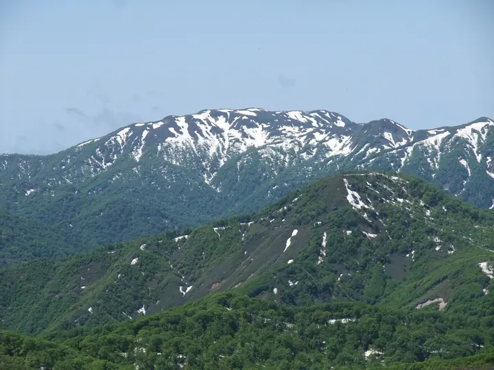
Mount Shirakami is the highest summit of the Shirakami Mountains at 1,235 m, in Fukaura Town, Nishi-Tsugaru District, Aomori Prefecture. The peak rises on the edge of the Shirakami-Sanchi UNESCO World Heritage Site (registered 1993), and from the summit climbers look out over the core zone of one of Asia's last great primeval beech forests. It is included in the Nihon Nihyaku Meizan, the Ittō-Sankakuten Hyakumeizan, the Tōhoku Hyakumeizan, and the Aomori 110 Mountains; the name "Shirakami" already appears in 1645 records of the Hirosaki domain. The standard line is the Mateyama route, an eight-hour round trip from the Kurosaki trailhead at 200 m, climbing through hiba, nezuko, and beech forest before emerging onto wind-swept alpine meadow; an emergency shelter and toilet stand just below the summit. A second, longer line traverses from the Jūniko lakes via Mount Ōmine. The practical climbing season runs from June through October.
Mount Shirakami at a glance
- Weather: The most settled day in the next 7 days is Thu, November 5: cloudy, gusts up to 9 m/s. Fri, Nov 6, Sat, Nov 7, Sun, Nov 8: strong wind (gusts up to 29 m/s).
- Route: The shortest is Mount Shirakami via the Mateyama Course: about 8 h 23 min, 13.3 km, about 1,240 m of climbing.
Mount Shirakami weather (hourly, 14 days)
Sunrise today 06:11, sunset 16:36
| Tue, 11/3 | Wed, 11/4 | Thu, 11/5 | Fri, 11/6 | Sat, 11/7 | Sun, 11/8 | Mon, 11/9 | Tue, 11/10 | Wed, 11/11 | Thu, 11/12 | Fri, 11/13 | Sat, 11/14 | Sun, 11/15 | Mon, 11/16 | Tue, 11/17 | |||||||||||||||||||||||||||||||||||||||||||||||||||||||||||||||||||||||
|---|---|---|---|---|---|---|---|---|---|---|---|---|---|---|---|---|---|---|---|---|---|---|---|---|---|---|---|---|---|---|---|---|---|---|---|---|---|---|---|---|---|---|---|---|---|---|---|---|---|---|---|---|---|---|---|---|---|---|---|---|---|---|---|---|---|---|---|---|---|---|---|---|---|---|---|---|---|---|---|---|---|---|---|---|---|
| Japan time | 21 | 23 | 1 | 3 | 5 | 7 | 9 | 11 | 13 | 15 | 17 | 19 | 21 | 0 | 3 | 6 | 9 | 12 | 15 | 18 | 21 | 0 | 3 | 6 | 9 | 12 | 15 | 18 | 21 | 0 | 3 | 6 | 9 | 12 | 15 | 18 | 21 | 0 | 3 | 6 | 9 | 12 | 15 | 18 | 21 | 0 | 3 | 6 | 9 | 12 | 15 | 21 | 3 | 9 | 15 | 21 | 3 | 9 | 15 | 21 | 3 | 9 | 15 | 21 | 3 | 9 | 15 | 21 | 3 | 9 | 15 | 21 | 3 | 9 | 15 | 21 | 3 | 9 | 15 | 21 | 3 | 9 | 15 | 21 | |
  |   | |   | |  |   | | | | | | | | |   |   |   | |   | | | | | |   |   | | |   |   |   |   | |   |   | |   |   | |   | | | | | | | | |   | | | |   | | | | | | | |   | | | | | | |   | | |  | | | | | | | | | | | | | ||
| Temperature | °C | 0° | 1° | 3° | 3° | 3° | 3° | 5° | 6° | 6° | 5° | 1° | -2° | -2° | -2° | -1° | 3° | 7° | 9° | 8° | 5° | 5° | 6° | 6° | 6° | 8° | 6° | 6° | 2° | -1° | -3° | -3° | -3° | -3° | -2° | -2° | -4° | -3° | -4° | -4° | -4° | -2° | -2° | -2° | -3° | -3° | -4° | -5° | -5° | -4° | -3° | -4° | -4° | -5° | -2° | 0° | -3° | -2° | -3° | -1° | -3° | -2° | 1° | 1° | -1° | -4° | -2° | -2° | -3° | -3° | 1° | 1° | -3° | -2° | 3° | 4° | 2° | 2° | 3° | -1° | -4° | -3° | 0° | 0° | -2° |
| Precipitation | mm | 0.2 | 0.2 | 0.7 | 0.9 | 0.1 | 0.2 | 0.2 | 3.3 | 3.2 | 1.2 | 0.9 | 2.4 | 2.9 | 0.5 | 0.3 | 1.2 | 1.4 | 1.6 | 1.5 | 2.2 | 1.5 | 2.2 | 1.5 | 2.1 | 1.1 | 0.4 | 0.3 | 0.6 | 0.3 | 1.1 | 1.2 | 2.6 | 1.4 | 0.4 | 0.4 | 0.1 | 0.2 | 2.5 | 4.9 | 9 | 0.6 | 1.0 | 0.6 | 6 | 2.1 | 0.3 | 0.2 | 0.1 | 2.4 | 4.5 | 2.6 | 8 | 2.0 | 0.2 | 0.1 | |||||||||||||||||||||||||||||
| New snow | cm | 0.6 | 1.2 | 1.3 | 1.3 | 2.0 | 1.1 | 1.8 | 1.1 | 1.8 | 0.9 | 0.4 | 0.3 | 0.6 | 0.3 | <.1 | <.1 | <.1 | 0.9 | 1.0 | 2.3 | 1.1 | 1.1 | 0.3 | 0.1 | 0.1 | 2.1 | 2.9 | 6.0 | 0.2 | <.1 | 0.6 | 0.2 | 0.2 | <.1 | 0.3 | 1.3 | 0.2 | |||||||||||||||||||||||||||||||||||||||||||||||
| Snow depth | cm | 0 | 0 | 0 | 0 | 0 | 0 | 0 | 0 | 0 | 0 | 0 | 0 | 0 | 0 | 0 | 0 | 0 | 0 | 0 | 0 | 0 | 0 | 0 | 0 | 0 | 0 | 0 | 0 | 0 | 0 | <1 | 1 | 2 | 2 | 2 | 3 | 4 | 4 | 4 | 5 | 5 | 5 | 4 | 4 | 4 | 4 | 4 | 3 | 3 | 3 | 4 | 4 | 4 | 4 | 3 | 5 | 6 | 10 | 8 | 7 | 7 | 7 | 5 | 5 | 5 | 5 | 5 | 5 | 5 | 4 | 4 | 3 | 3 | 3 | 2 | 1 | <1 | <1 | <1 | 1 | 1 | 1 | <1 | <1 |
| Wind | m/s | 3 | 4 | 5 | 6 | 5 | 4 | 4 | 2 | 2 | 1 | 1 | 1 | 1 | 1 | 1 | 3 | 3 | 1 | 1 | 2 | 1 | 3 | 3 | 4 | 5 | 6 | 7 | 7 | 8 | 7 | 7 | 9 | 9 | 10 | 8 | 8 | 7 | 7 | 7 | 5 | 6 | 6 | 5 | 4 | 2 | 0 | 0 | 0 | 1 | 3 | 3 | 2 | 1 | 1 | 3 | 4 | 2 | 5 | 2 | 1 | 2 | 4 | 4 | 1 | 3 | 4 | 4 | 2 | 0 | 2 | 2 | 2 | 3 | 3 | 2 | 3 | 1 | 3 | 5 | 4 | 3 | 3 | 2 | 1 |
| Wind gusts | m/s | 11 | 10 | 15 | 16 | 16 | 13 | 11 | 10 | 8 | 6 | 4 | 3 | 4 | 4 | 5 | 8 | 9 | 8 | 6 | 5 | 5 | 8 | 10 | 10 | 12 | 18 | 21 | 21 | 21 | 22 | 22 | 25 | 25 | 29 | 29 | 25 | 22 | 21 | 19 | 18 | 17 | 16 | 16 | 14 | 10 | 6 | 4 | 4 | 5 | 8 | 9 | 8 | 5 | 5 | 8 | 13 | 15 | 14 | 14 | 7 | 6 | 11 | 11 | 10 | 8 | 12 | 13 | 11 | 7 | 6 | 7 | 6 | 7 | 8 | 8 | 12 | 10 | 9 | 14 | 15 | 11 | 9 | 8 | 6 |
| Wind dir. | ↓ | ↓ | ↓ | ↓ | ↓ | ↓ | ↓ | ↓ | ↓ | ↓ | ↓ | ↓ | ↓ | ↓ | ↓ | ↓ | ↓ | ↓ | ↓ | ↓ | ↓ | ↓ | ↓ | ↓ | ↓ | ↓ | ↓ | ↓ | ↓ | ↓ | ↓ | ↓ | ↓ | ↓ | ↓ | ↓ | ↓ | ↓ | ↓ | ↓ | ↓ | ↓ | ↓ | ↓ | ↓ | ↓ | ↓ | ↓ | ↓ | ↓ | ↓ | ↓ | ↓ | ↓ | ↓ | ↓ | ↓ | ↓ | ↓ | ↓ | ↓ | ↓ | ↓ | ↓ | ↓ | ↓ | ↓ | ↓ | ↓ | ↓ | ↓ | ↓ | ↓ | ↓ | ↓ | ↓ | ↓ | ↓ | ↓ | ↓ | ↓ | ↓ | ↓ | ↓ | |
Mount Shirakami hiking routes
Hiking times are estimates calculated from the terrain.
Huts, campsites and lodging near Mount Shirakami
Mountain huts
- 白神岳避難小屋
Lists that include Mount Shirakami
Japan 200 Famous Mountains · Japan's 300 Famous Mountains · 100 Famous Mountains with First-order Triangulation Points · New Japan 100 Famous Mountains · Tohoku 100 Famous Mountains · 110 Mountains of Aomori · Elevations of 1003 Mountains of Japan · 1000 Mountains of Japan
Mount Shirakami facts
- Elevation
- 1,235 m
- Location
- Fukaura, Aomori
40.503623, 140.018671 - Website
- www.shirakami-visitor.jp
- Trail Map
- www.town.fukaura.lg.jp
- Access Information
- www.town.fukaura.lg.jp
- Wikipedia
- ja.wikipedia.org