
Mount Shirakami
白神岳
ฟูกาอูระ, อาโอโมริ · ความสูง 1,235 ม.
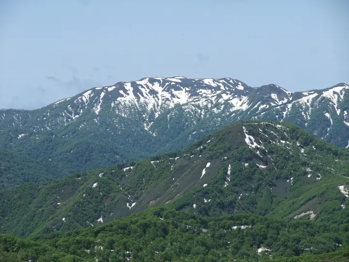
Mount Shirakami is the highest summit of the Shirakami Mountains at 1,235 m, in Fukaura Town, Nishi-Tsugaru District, Aomori Prefecture. The peak rises on the edge of the Shirakami-Sanchi UNESCO World Heritage Site (registered 1993), and from the summit climbers look out over the core zone of one of Asia's last great primeval beech forests. It is included in the Nihon Nihyaku Meizan, the Ittō-Sankakuten Hyakumeizan, the Tōhoku Hyakumeizan, and the Aomori 110 Mountains; the name "Shirakami" already appears in 1645 records of the Hirosaki domain. The standard line is the Mateyama route, an eight-hour round trip from the Kurosaki trailhead at 200 m, climbing through hiba, nezuko, and beech forest before emerging onto wind-swept alpine meadow; an emergency shelter and toilet stand just below the summit. A second, longer line traverses from the Jūniko lakes via Mount Ōmine. The practical climbing season runs from June through October.
สรุป Mount Shirakami
- อากาศ: วันที่อากาศคงที่ที่สุดใน 7 วันข้างหน้าคือ พุธ 4 พฤศจิกายน: ท้องฟ้าแจ่มใส ลมกระโชกสูงสุด 14 ม./วินาที ศุกร์ 6 พ.ย., เสาร์ 7 พ.ย., อาทิตย์ 8 พ.ย. ลมแรง (ลมกระโชกสูงสุด 26 ม./วินาที)
- เส้นทาง: เส้นทางที่สั้นที่สุดคือ Mount Shirakami via the Mateyama Course: ประมาณ 8 ชม. 23 นาที 13.3 km ขึ้นประมาณ 1,240 m
อากาศ Mount Shirakami (รายชั่วโมง 2 สัปดาห์)
วันนี้พระอาทิตย์ขึ้น 06:11 ตก 16:36
| อังคาร 3/11 | พุธ 4/11 | พฤหัส 5/11 | ศุกร์ 6/11 | เสาร์ 7/11 | อาทิตย์ 8/11 | จันทร์ 9/11 | อังคาร 10/11 | พุธ 11/11 | พฤหัส 12/11 | ศุกร์ 13/11 | เสาร์ 14/11 | อาทิตย์ 15/11 | จันทร์ 16/11 | อังคาร 17/11 | |||||||||||||||||||||||||||||||||||||||||||||||||||||||||||||||||||||||
|---|---|---|---|---|---|---|---|---|---|---|---|---|---|---|---|---|---|---|---|---|---|---|---|---|---|---|---|---|---|---|---|---|---|---|---|---|---|---|---|---|---|---|---|---|---|---|---|---|---|---|---|---|---|---|---|---|---|---|---|---|---|---|---|---|---|---|---|---|---|---|---|---|---|---|---|---|---|---|---|---|---|---|---|---|---|
| เวลาญี่ปุ่น | 15 | 17 | 19 | 21 | 23 | 1 | 3 | 5 | 7 | 9 | 11 | 13 | 15 | 18 | 21 | 0 | 3 | 6 | 9 | 12 | 15 | 18 | 21 | 0 | 3 | 6 | 9 | 12 | 15 | 18 | 21 | 0 | 3 | 6 | 9 | 12 | 15 | 18 | 21 | 0 | 3 | 6 | 9 | 12 | 15 | 18 | 21 | 0 | 3 | 6 | 9 | 15 | 21 | 3 | 9 | 15 | 21 | 3 | 9 | 15 | 21 | 3 | 9 | 15 | 21 | 3 | 9 | 15 | 21 | 3 | 9 | 15 | 21 | 3 | 9 | 15 | 21 | 3 | 9 | 15 | 21 | 3 | 9 | 15 | |
  |   | | |   | |   | |  |   | | | | | | | |   |   | |   | | | | |   |   | | | | |   | |   |   |   |   | | |   | | | |   | | | | |   | | | | | | |   | |   |   | | | | | | | | | | |   | | |  | | | | | | | | | | | | ||
| อุณหภูมิ | °C | 2° | 0° | 1° | 0° | 1° | 3° | 4° | 3° | 2° | 5° | 5° | 6° | 5° | 0° | -2° | -1° | -1° | 1° | 8° | 9° | 8° | 5° | 4° | 5° | 5° | 5° | 8° | 7° | 5° | 2° | -1° | -3° | -3° | -4° | -3° | -2° | -2° | -3° | -3° | -3° | -3° | -3° | -2° | -1° | -2° | -2° | -2° | -2° | -2° | -4° | -3° | -2° | -4° | -5° | -2° | 0° | -3° | -2° | -3° | -1° | -3° | -2° | 1° | 1° | -1° | -4° | -2° | -2° | -3° | -3° | 1° | 1° | -3° | -2° | 3° | 4° | 2° | 2° | 3° | -1° | -4° | -3° | 0° | 0° |
| ฝนและหิมะ | mm | 0.2 | 0.2 | 0.1 | 0.2 | 1.1 | 0.1 | 0.2 | 0.5 | 0.7 | 0.3 | 0.5 | 1.6 | 4.8 | 3.3 | 0.4 | 0.2 | 0.9 | 1.4 | 1.6 | 1.7 | 2.0 | 1.7 | 1.5 | 2.3 | 1.2 | 1.9 | 1.2 | 0.2 | 0.3 | 0.3 | 0.2 | 0.5 | 1.4 | 0.4 | 0.1 | 0.2 | 2.5 | 4.9 | 9 | 0.6 | 1.0 | 0.6 | 6 | 2.1 | 0.3 | 0.2 | 0.1 | 2.4 | 4.5 | 2.6 | 8 | 2.0 | 0.2 | 0.1 | ||||||||||||||||||||||||||||||
| หิมะตก | cm | 0.5 | 0.9 | 1.3 | 1.5 | 1.8 | 1.4 | 1.2 | 1.9 | 1.0 | 1.5 | 1.1 | 0.2 | 0.3 | 0.3 | <.1 | 0.1 | 0.5 | 1.1 | 0.3 | 0.1 | 0.1 | 2.1 | 2.9 | 6.0 | 0.2 | <.1 | 0.6 | 0.2 | 0.2 | <.1 | 0.3 | 1.3 | 0.2 | |||||||||||||||||||||||||||||||||||||||||||||||||||
| หิมะสะสม | cm | 0 | 0 | 0 | 0 | 0 | 0 | 0 | 0 | 0 | 0 | 0 | 0 | 0 | 0 | 0 | 0 | 0 | 0 | 0 | 0 | 0 | 0 | 0 | 0 | 0 | 0 | 0 | 0 | 0 | 0 | 0 | 0 | <1 | 1 | 2 | 2 | 2 | 3 | 4 | 4 | 4 | 5 | 5 | 5 | 4 | 4 | 4 | 4 | 4 | 3 | 3 | 4 | 4 | 4 | 4 | 3 | 5 | 6 | 10 | 8 | 7 | 7 | 7 | 5 | 5 | 5 | 5 | 5 | 5 | 5 | 4 | 4 | 3 | 3 | 3 | 2 | 1 | <1 | <1 | <1 | 1 | 1 | 1 | <1 |
| ลม | m/s | 5 | 3 | 4 | 3 | 4 | 5 | 7 | 5 | 3 | 4 | 2 | 2 | 1 | 2 | 2 | 1 | 1 | 2 | 3 | 3 | 1 | 1 | 1 | 2 | 2 | 2 | 4 | 5 | 6 | 7 | 8 | 6 | 7 | 8 | 8 | 9 | 8 | 8 | 8 | 8 | 8 | 7 | 7 | 7 | 6 | 5 | 4 | 3 | 3 | 2 | 3 | 3 | 2 | 1 | 1 | 3 | 4 | 2 | 5 | 2 | 1 | 2 | 4 | 4 | 1 | 3 | 4 | 4 | 2 | 0 | 2 | 2 | 2 | 3 | 3 | 2 | 3 | 1 | 3 | 5 | 4 | 3 | 3 | 2 |
| ลมกระโชก | m/s | 16 | 13 | 10 | 10 | 10 | 15 | 18 | 18 | 14 | 10 | 10 | 7 | 6 | 4 | 5 | 5 | 5 | 7 | 10 | 10 | 9 | 4 | 3 | 5 | 6 | 7 | 11 | 17 | 18 | 19 | 21 | 20 | 20 | 24 | 25 | 26 | 26 | 25 | 23 | 21 | 22 | 22 | 20 | 20 | 19 | 16 | 14 | 10 | 10 | 9 | 8 | 10 | 8 | 5 | 5 | 8 | 13 | 15 | 14 | 14 | 7 | 6 | 11 | 11 | 10 | 8 | 12 | 13 | 11 | 7 | 6 | 7 | 6 | 7 | 8 | 8 | 12 | 10 | 9 | 14 | 15 | 11 | 9 | 8 |
| ทิศทางลม | ↓ | ↓ | ↓ | ↓ | ↓ | ↓ | ↓ | ↓ | ↓ | ↓ | ↓ | ↓ | ↓ | ↓ | ↓ | ↓ | ↓ | ↓ | ↓ | ↓ | ↓ | ↓ | ↓ | ↓ | ↓ | ↓ | ↓ | ↓ | ↓ | ↓ | ↓ | ↓ | ↓ | ↓ | ↓ | ↓ | ↓ | ↓ | ↓ | ↓ | ↓ | ↓ | ↓ | ↓ | ↓ | ↓ | ↓ | ↓ | ↓ | ↓ | ↓ | ↓ | ↓ | ↓ | ↓ | ↓ | ↓ | ↓ | ↓ | ↓ | ↓ | ↓ | ↓ | ↓ | ↓ | ↓ | ↓ | ↓ | ↓ | ↓ | ↓ | ↓ | ↓ | ↓ | ↓ | ↓ | ↓ | ↓ | ↓ | ↓ | ↓ | ↓ | ↓ | ↓ | |
เส้นทางเดินป่า Mount Shirakami
เวลาเดินเป็นค่าประมาณที่คำนวณจากภูมิประเทศ
กระท่อม ที่ตั้งแคมป์ และที่พักใกล้ Mount Shirakami
กระท่อมบนภูเขา
- 白神岳避難小屋
รายชื่อที่มี Mount Shirakami
200 ภูเขาที่มีชื่อเสียงของญี่ปุ่น · 300 ภูเขาที่มีชื่อเสียงของญี่ปุ่น · 100 ภูเขาที่มีชื่อเสียงซึ่งมีหมุดสามเหลี่ยมชั้นหนึ่ง · 100 ภูเขาที่มีชื่อเสียงของญี่ปุ่นชุดใหม่ · 100 ภูเขาที่มีชื่อเสียงของโทโฮกุ · ภูเขา 110 แห่งของอาโอโมริ · ระดับความสูงของภูเขา 1003 แห่งในญี่ปุ่น · ภูเขา 1000 แห่งของญี่ปุ่น
ข้อมูลพื้นฐาน Mount Shirakami
- ความสูง
- 1,235 ม.
- ที่ตั้ง
- ฟูกาอูระ, อาโอโมริ
40.503623, 140.018671 - เว็บไซต์
- www.shirakami-visitor.jp
- แผนที่เส้นทางเดินเขา
- www.town.fukaura.lg.jp
- ข้อมูลการเดินทาง
- www.town.fukaura.lg.jp
- วิกิพีเดีย
- ja.wikipedia.org