
Mount Kodake
小岳
Fujisato, Akita · Elevation 1,042 m
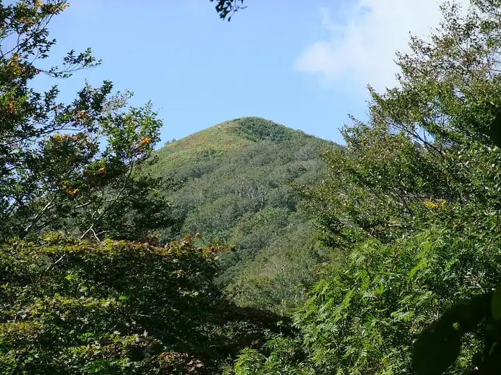
Mount Kodake (1,042 m) is a remote summit in Fujisato Town, Akita Prefecture, sitting just inside the Akita-Shirakami range — the western flank of its summit ridge falls within the Shirakami-Sanchi UNESCO World Heritage zone. Beech forest cloaks the peak, and the area harbours what is said to be the lowest-elevation natural stand of Japanese stone pine on Honshū. The trailhead is reached only via about 20 km of unpaved forest road from Sunaori Park, and the ascent takes around two hours one way. The mountain is included in the One Hundred Mountains of Tōhoku.
Mount Kodake at a glance
- Weather: The most settled day in the next 7 days is Thu, November 5: cloudy, gusts up to 7 m/s. Fri, Nov 6, Sat, Nov 7, Sun, Nov 8: strong wind (gusts up to 24 m/s).
Mount Kodake weather (hourly, 14 days)
Sunrise today 06:10, sunset 16:35
| Tue, 11/3 | Wed, 11/4 | Thu, 11/5 | Fri, 11/6 | Sat, 11/7 | Sun, 11/8 | Mon, 11/9 | Tue, 11/10 | Wed, 11/11 | Thu, 11/12 | Fri, 11/13 | Sat, 11/14 | Sun, 11/15 | Mon, 11/16 | Tue, 11/17 | |||||||||||||||||||||||||||||||||||||||||||||||||||||||||||||||||||||
|---|---|---|---|---|---|---|---|---|---|---|---|---|---|---|---|---|---|---|---|---|---|---|---|---|---|---|---|---|---|---|---|---|---|---|---|---|---|---|---|---|---|---|---|---|---|---|---|---|---|---|---|---|---|---|---|---|---|---|---|---|---|---|---|---|---|---|---|---|---|---|---|---|---|---|---|---|---|---|---|---|---|---|---|
| Japan time | 21 | 23 | 1 | 3 | 5 | 7 | 9 | 11 | 13 | 15 | 17 | 19 | 21 | 0 | 3 | 6 | 9 | 12 | 15 | 18 | 21 | 0 | 3 | 6 | 9 | 12 | 15 | 18 | 21 | 0 | 3 | 6 | 9 | 12 | 15 | 18 | 21 | 0 | 3 | 6 | 9 | 12 | 15 | 18 | 21 | 0 | 3 | 6 | 9 | 15 | 21 | 3 | 9 | 15 | 21 | 3 | 9 | 15 | 21 | 3 | 9 | 15 | 21 | 3 | 9 | 15 | 21 | 3 | 9 | 15 | 21 | 3 | 9 | 15 | 21 | 3 | 9 | 15 | 21 | 3 | 9 | 15 | |
  | |   | | |   |  | | |   |  |   | | | |   |   |   |   |   | | | | | | | | | |   |   | |   | | | |   | | | |   | | | | | | | | | | | |   | | |   | | | | |   | | | | | | | | | | |  | | | | | |   | | | | | ||
| Temperature | °C | 0° | 1° | 3° | 2° | 3° | 3° | 5° | 6° | 7° | 6° | 2° | 0° | 1° | 3° | 3° | 5° | 7° | 8° | 8° | 6° | 5° | 6° | 6° | 5° | 8° | 7° | 6° | 2° | 0° | -2° | -3° | -3° | -2° | -2° | -2° | -2° | -3° | -3° | -4° | -4° | -2° | -1° | -2° | -2° | -2° | -2° | -2° | -4° | -2° | -2° | -5° | -5° | -2° | 1° | -2° | -2° | -1° | -1° | -3° | -2° | 1° | 1° | -1° | -5° | -2° | -2° | -4° | -4° | 1° | 1° | -2° | -2° | 3° | 4° | 2° | 2° | 4° | -1° | -4° | -3° | 0° | 0° |
| Precipitation | mm | 0.2 | 0.1 | 0.6 | 0.6 | 0.1 | 0.2 | 0.5 | 0.3 | 1.1 | 1.4 | 0.3 | 0.4 | 0.8 | 4.9 | 3.0 | 0.5 | 0.2 | 0.5 | 0.9 | 0.8 | 1.4 | 1.5 | 1.4 | 0.8 | 0.9 | 0.9 | 1.4 | 0.5 | 0.3 | 0.3 | 0.4 | 0.5 | 1.5 | 0.3 | 4.8 | 6 | 10 | 0.4 | 0.2 | 0.7 | 6 | 1.3 | 3.9 | 7 | 1.4 | 4.8 | 1.7 | |||||||||||||||||||||||||||||||||||
| New snow | cm | – | – | 0.4 | 0.9 | 0.8 | 1.4 | 1.5 | 1.3 | 0.8 | 0.9 | 0.8 | 1.4 | 0.5 | 0.3 | 0.2 | 0.4 | <.1 | <.1 | 0.5 | 1.4 | 0.3 | <.1 | <.1 | 4.7 | 4.2 | 8.3 | 0.3 | 0.9 | 0.1 | <.1 | <.1 | 0.6 | 1.4 | <.1 | ||||||||||||||||||||||||||||||||||||||||||||||||
| Snow depth | cm | 0 | 0 | 0 | 0 | 0 | 0 | 0 | 0 | 0 | 0 | 0 | 0 | 0 | 0 | 0 | 0 | 0 | 0 | 0 | 0 | 0 | 0 | 0 | 0 | 0 | 0 | 0 | 0 | 0 | 0 | <1 | <1 | 2 | 2 | 3 | 3 | 3 | 4 | 4 | 5 | 5 | 5 | 5 | 5 | 4 | 4 | 4 | 4 | 5 | 5 | 5 | 5 | 5 | 4 | 7 | 9 | 13 | 11 | 11 | 10 | 10 | 8 | 8 | 7 | 7 | 7 | 7 | 7 | 7 | 5 | 5 | 5 | 4 | 2 | 2 | 1 | <1 | <1 | 2 | 2 | <1 | <1 |
| Wind | m/s | 3 | 4 | 6 | 5 | 5 | 4 | 4 | 3 | 2 | 2 | 0 | 1 | 1 | 1 | 2 | 2 | 2 | 3 | 3 | 1 | 1 | 1 | 1 | 1 | 3 | 6 | 6 | 8 | 8 | 6 | 7 | 8 | 8 | 8 | 8 | 8 | 8 | 7 | 8 | 7 | 7 | 7 | 6 | 6 | 4 | 3 | 3 | 1 | 3 | 3 | 1 | 2 | 2 | 4 | 5 | 2 | 5 | 2 | 1 | 2 | 5 | 3 | 1 | 2 | 4 | 4 | 2 | 1 | 2 | 2 | 1 | 1 | 1 | 1 | 1 | 0 | 3 | 4 | 3 | 3 | 3 | 2 |
| Wind gusts | m/s | 10 | 9 | 14 | 15 | 14 | 12 | 11 | 10 | 8 | 6 | 4 | 2 | 2 | 3 | 4 | 6 | 6 | 6 | 7 | 4 | 3 | 2 | 3 | 4 | 8 | 16 | 17 | 18 | 20 | 19 | 18 | 21 | 22 | 24 | 24 | 22 | 20 | 19 | 19 | 19 | 18 | 18 | 18 | 15 | 13 | 10 | 8 | 7 | 7 | 9 | 7 | 5 | 5 | 9 | 13 | 14 | 14 | 14 | 6 | 5 | 12 | 12 | 9 | 6 | 10 | 12 | 10 | 5 | 6 | 8 | 5 | 3 | 4 | 6 | 6 | 5 | 6 | 12 | 13 | 9 | 8 | 8 |
| Wind dir. | ↓ | ↓ | ↓ | ↓ | ↓ | ↓ | ↓ | ↓ | ↓ | ↓ | ↓ | ↓ | ↓ | ↓ | ↓ | ↓ | ↓ | ↓ | ↓ | ↓ | ↓ | ↓ | ↓ | ↓ | ↓ | ↓ | ↓ | ↓ | ↓ | ↓ | ↓ | ↓ | ↓ | ↓ | ↓ | ↓ | ↓ | ↓ | ↓ | ↓ | ↓ | ↓ | ↓ | ↓ | ↓ | ↓ | ↓ | ↓ | ↓ | ↓ | ↓ | ↓ | ↓ | ↓ | ↓ | ↓ | ↓ | ↓ | ↓ | ↓ | ↓ | ↓ | ↓ | ↓ | ↓ | ↓ | ↓ | ↓ | ↓ | ↓ | ↓ | ↓ | ↓ | ↓ | ↓ | ↓ | ↓ | ↓ | ↓ | ↓ | ↓ | ↓ | |
Lists that include Mount Kodake
Mount Kodake facts
- Elevation
- 1,042 m
- Location
- Fujisato, Akita
40.432800, 140.197783 - Website
- common3.pref.akita.lg.jp
- Wikipedia
- ja.wikipedia.org