
Mount Furano
富良野岳
Kamifurano, Hokkaido · Elevation 1,912 m
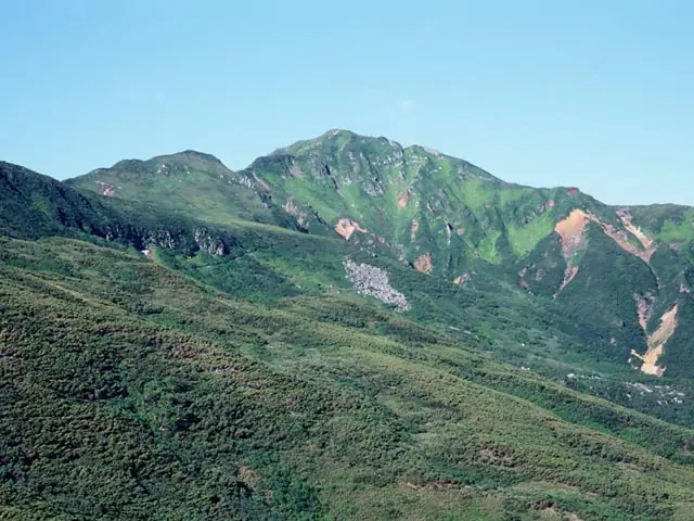
Mount Furano is a 1,912 m peak in Kamifurano Town, Hokkaido, anchoring the south-western end of the Tokachi range in the core of Daisetsuzan National Park. Its slopes are a treasury of alpine flowers — chinguruma, Ezo-no-tsugazakura, Ezo-kozakura, komakusa — and in early to mid-July they transform into one of Japan's most celebrated wildflower meadows, fitting its place in Hana no Hyakumeizan. The standard ascent leaves the Tokachidake Onsen Ryōunkaku hut, branching from the Kami-Horo-Kamettoku and Sandanyama routes, and reaches the summit in about four hours. The peak also features in Ittō-Sankakuten Hyakumeizan and Hokkaidō Hyakumeizan.
Mount Furano at a glance
- Weather: The most settled day in the next 7 days is Thu, November 5: cloudy, gusts up to 8 m/s. Wed, Nov 4, Sat, Nov 7, Sun, Nov 8: strong wind (gusts up to 22 m/s).
- Route: The shortest is Mount Furano Loop via Mount Kamifurano and Mount Sanpo from Tokachidake Onsen: about 7 h 29 min, 12.1 km, about 1,030 m of climbing.
Mount Furano weather (hourly, 14 days)
Sunrise today 06:06, sunset 16:20
| Tue, 11/3 | Wed, 11/4 | Thu, 11/5 | Fri, 11/6 | Sat, 11/7 | Sun, 11/8 | Mon, 11/9 | Tue, 11/10 | Wed, 11/11 | Thu, 11/12 | Fri, 11/13 | Sat, 11/14 | Sun, 11/15 | Mon, 11/16 | Tue, 11/17 | |||||||||||||||||||||||||||||||||||||||||||||||||||||||||||||||||||||||
|---|---|---|---|---|---|---|---|---|---|---|---|---|---|---|---|---|---|---|---|---|---|---|---|---|---|---|---|---|---|---|---|---|---|---|---|---|---|---|---|---|---|---|---|---|---|---|---|---|---|---|---|---|---|---|---|---|---|---|---|---|---|---|---|---|---|---|---|---|---|---|---|---|---|---|---|---|---|---|---|---|---|---|---|---|---|
| Japan time | 15 | 17 | 19 | 21 | 23 | 1 | 3 | 5 | 7 | 9 | 11 | 13 | 15 | 18 | 21 | 0 | 3 | 6 | 9 | 12 | 15 | 18 | 21 | 0 | 3 | 6 | 9 | 12 | 15 | 18 | 21 | 0 | 3 | 6 | 9 | 12 | 15 | 18 | 21 | 0 | 3 | 6 | 9 | 12 | 15 | 18 | 21 | 0 | 3 | 6 | 9 | 15 | 21 | 3 | 9 | 15 | 21 | 3 | 9 | 15 | 21 | 3 | 9 | 15 | 21 | 3 | 9 | 15 | 21 | 3 | 9 | 15 | 21 | 3 | 9 | 15 | 21 | 3 | 9 | 15 | 21 | 3 | 9 | 15 | |
  |   | |   | |   | | |   | |   | |  |   |  | | | | |   | | | |   | | |   | |   | | | |   |   | | | | | | | | | | | | | | | | | | | | | | | | | | | | | | | | | | | |  | | | | | | | | | | | | | |   | ||
| Temperature | °C | -6° | -8° | -9° | -8° | -8° | -9° | -8° | -7° | -7° | -6° | -5° | -4° | -5° | -11° | -9° | -8° | -7° | -6° | 0° | 2° | 1° | -2° | -2° | -2° | -2° | -1° | 0° | 2° | 3° | -2° | -5° | -8° | -10° | -11° | -10° | -10° | -11° | -11° | -11° | -11° | -12° | -12° | -10° | -9° | -10° | -10° | -10° | -10° | -11° | -11° | -10° | -10° | -13° | -12° | -10° | -9° | -14° | -11° | -8° | -6° | -13° | -12° | -8° | -8° | -10° | -12° | -12° | -11° | -12° | -13° | -8° | -7° | -10° | -7° | -2° | -3° | -3° | -3° | -4° | -7° | -10° | -11° | -9° | -8° |
| Precipitation | mm | 0.2 | 2.6 | 0.1 | 0.1 | 1.4 | 1.8 | 1.1 | 5 | 1.0 | 0.5 | 2.2 | 0.2 | 1.2 | 0.3 | 0.1 | 0.3 | 1.3 | 2.2 | 1.4 | 2.2 | 1.8 | 1.8 | 1.6 | 1.4 | 0.7 | 0.6 | 0.2 | 0.1 | 0.1 | 0.1 | 0.4 | 0.3 | 0.2 | 1.1 | 2.2 | 0.2 | 0.9 | 0.1 | 0.5 | 1.0 | 0.7 | 1.1 | 0.3 | 1.5 | 1.7 | 1.4 | 2.4 | 1.7 | 0.8 | 0.3 | ||||||||||||||||||||||||||||||||||
| New snow | cm | <.1 | 0.2 | 2.6 | 0.1 | 0.1 | <.1 | <.1 | <.1 | 1.2 | 0.2 | 0.1 | 0.3 | 1.3 | 2.2 | 1.4 | 2.2 | 1.8 | 1.8 | 1.6 | 1.4 | 0.7 | 0.6 | 0.2 | <.1 | 0.1 | <.1 | 0.1 | 0.1 | 0.4 | <.1 | 0.2 | 0.2 | 1.1 | 2.2 | 0.2 | 0.9 | 0.1 | 0.5 | 1.0 | 0.7 | 1.1 | 2.2 | 1.7 | 0.7 | 0.3 | |||||||||||||||||||||||||||||||||||||||
| Snow depth | cm | 2 | 2 | 2 | 2 | 2 | 2 | 4 | 5 | 4 | 4 | 4 | 4 | 4 | 4 | 4 | 4 | 4 | 4 | 4 | 3 | 2 | 2 | 2 | 2 | 2 | <1 | <1 | <1 | <1 | <1 | <1 | 1 | 1 | 1 | 1 | 2 | 4 | 5 | 6 | 7 | 9 | 10 | 11 | 11 | 11 | 11 | 11 | 11 | 11 | 10 | 10 | 10 | 10 | 10 | 10 | 10 | 10 | 10 | 12 | 11 | 11 | 11 | 11 | 12 | 11 | 12 | 13 | 13 | 13 | 13 | 13 | 13 | 13 | 12 | 12 | 10 | 10 | 9 | 8 | 10 | 11 | 11 | 11 | 11 |
| Wind | m/s | 5 | 4 | 3 | 3 | 0 | 0 | 1 | 4 | 6 | 6 | 5 | 5 | 3 | 1 | 1 | 1 | 0 | 1 | 1 | 2 | 1 | 1 | 2 | 1 | 2 | 2 | 2 | 1 | 4 | 5 | 4 | 7 | 5 | 5 | 6 | 6 | 5 | 6 | 7 | 6 | 7 | 6 | 6 | 8 | 7 | 6 | 5 | 5 | 5 | 4 | 4 | 4 | 3 | 2 | 2 | 2 | 2 | 3 | 2 | 0 | 1 | 1 | 1 | 4 | 4 | 4 | 5 | 5 | 5 | 3 | 3 | 2 | 2 | 1 | 1 | 1 | 1 | 1 | 3 | 5 | 4 | 5 | 4 | 2 |
| Wind gusts | m/s | 16 | 14 | 10 | 11 | 10 | 6 | 8 | 11 | 17 | 18 | 17 | 15 | 14 | 10 | 5 | 5 | 6 | 6 | 7 | 8 | 8 | 5 | 5 | 5 | 5 | 6 | 6 | 8 | 12 | 15 | 14 | 18 | 19 | 15 | 19 | 21 | 21 | 18 | 20 | 20 | 20 | 20 | 19 | 22 | 21 | 18 | 15 | 14 | 13 | 12 | 11 | 12 | 10 | 8 | 6 | 8 | 6 | 7 | 8 | 8 | 4 | 6 | 6 | 12 | 12 | 13 | 15 | 16 | 16 | 15 | 11 | 10 | 7 | 6 | 7 | 7 | 7 | 8 | 8 | 13 | 15 | 13 | 13 | 12 |
| Wind dir. | ↓ | ↓ | ↓ | ↓ | ↓ | ↓ | ↓ | ↓ | ↓ | ↓ | ↓ | ↓ | ↓ | ↓ | ↓ | ↓ | ↓ | ↓ | ↓ | ↓ | ↓ | ↓ | ↓ | ↓ | ↓ | ↓ | ↓ | ↓ | ↓ | ↓ | ↓ | ↓ | ↓ | ↓ | ↓ | ↓ | ↓ | ↓ | ↓ | ↓ | ↓ | ↓ | ↓ | ↓ | ↓ | ↓ | ↓ | ↓ | ↓ | ↓ | ↓ | ↓ | ↓ | ↓ | ↓ | ↓ | ↓ | ↓ | ↓ | ↓ | ↓ | ↓ | ↓ | ↓ | ↓ | ↓ | ↓ | ↓ | ↓ | ↓ | ↓ | ↓ | ↓ | ↓ | ↓ | ↓ | ↓ | ↓ | ↓ | ↓ | ↓ | ↓ | ↓ | ↓ | |
Mount Furano hiking routes
Hiking times are estimates calculated from the terrain.
Huts, campsites and lodging near Mount Furano
Mountain huts
Campsites
- 白銀荘前キャンプ場
Lodging
- 十勝岳温泉 湯元 凌雲閣
- カミホロ荘
- ホテル富良野思惟林
Lists that include Mount Furano
100 Famous Mountains of Flowers · 100 Famous Mountains with First-order Triangulation Points · 100 Famous Hot Spring Mountains · Hokkaido 100 Famous Mountains · Elevations of 1003 Mountains of Japan · 1000 Mountains of Japan
Mount Furano facts
- Elevation
- 1,912 m
- Location
- Kamifurano, Hokkaido
43.393736, 142.634983 - National Park
- 大雪山国立公園
- Website
- www.kamifurano.jp
- Trail Map
- www.town.kamifurano.hokkaido.jp (PDF)
- Wikipedia
- ja.wikipedia.org